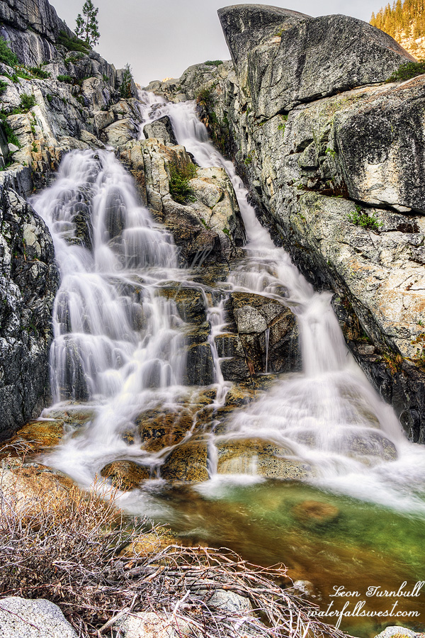
What I should have done is gotten up early, hiked down to the waterfall at the lower Canyon Creek Lakes (pictured here), and then continued on to Boulder Creek Lakes as originally planned. If I had done this, I do not know if things would have been better or worse for me (impossible to know), but in hindsight I definitely feel I should have done that. However, after my awesome first day with four waterfalls, I wanted to sleep in and have a relaxing morning. That’s it and that’s all. And that is what I did.
That meant I would have a very short day of hiking. Uh huh. Sure, Madman. Whatever you say. It was only 1.5 hours back down to the lower Canyon Creek Lakes. I arrived at 11AM. No one was camped at the spot I saw on my way up, which is where I wanted to set up at the end of the lake. It was a perfect spot. It sure seemed like a perfect spot. Why wouldn’t it be a perfect spot?
I ate my lunch. I set up my tent. I had seven hours to wait for the sun before I could go down to the waterfall and take photos. Seven hours! What could I possibly do for seven hours!? I walked to the end of the lake and back. That took 30 minutes. This is perhaps the biggest reason why I should have gotten up early instead of sleeping in. There was nothing else to do all day long.
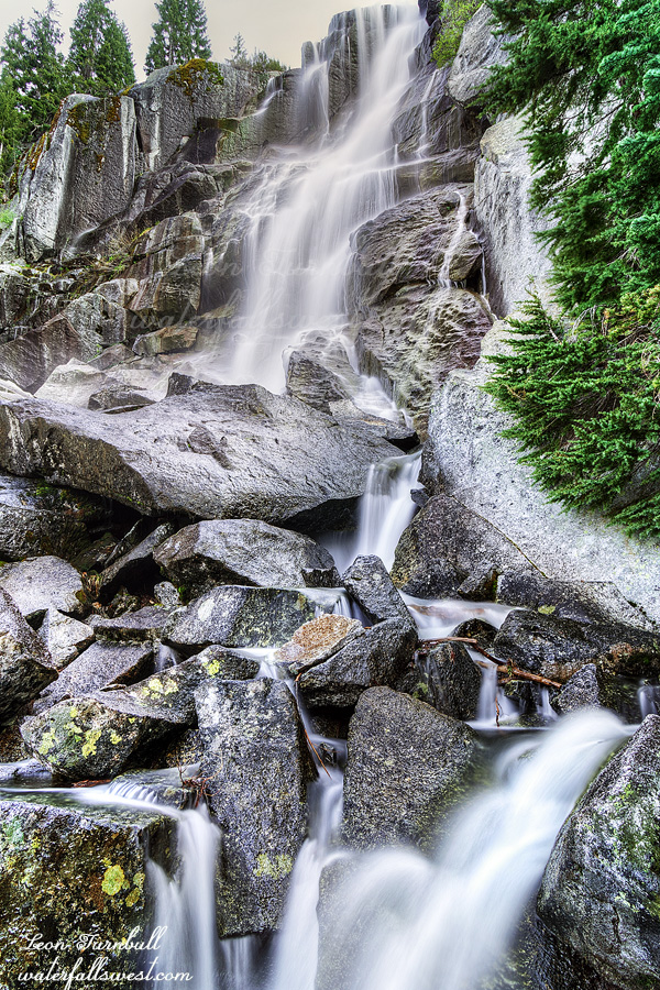
In the afternoon clouds rolled in. I decided to go down to the waterfall and check it out. Since it was cloudy I took some photos. This was the smartest thing I did all day. It was easy getting down to it so I was going to come back later in the evening as well. Canyon Creek Lakes Falls is a very lovely 85 ft. cascade. I had not been to it before (it is not too far above the Far Upper Canyon Creek Falls) and I was not expecting to find such a nice waterfall here. This is why I wanted to make sure I got to this one in good lighting conditions and why I decided to take an extra day camping at the lower lake. It would have been a good decision … HOWEVER …
20% chance of thunderstorms … this was the forecast. What does that mean to you? To me, this means that worst case scenario you might see a quick thunderstorm in the afternoon, lasting no more than 15 or 20 minutes. At worst. Most likely you will see nothing at all. Am I wrong? I don’t think I am wrong. Certainly nothing that would be life threatening or into the danger zone. At 5:45PM it started sprinking. I moved everything into the tent, including myself. The thunderstorm started at 6:15PM. It lasted for 2.5 hours! The first hour was a bit on and off, with heavy rain and wind, much lightning and thunder. The last 1.5 hours it was all on, non-stop. Pelting rain. Pounding wind. Lightning. Thunder. Non-stop. The heavy rain and wind did not let up even for one minute. I am not joking. I don’t know how much it rained but at that intensity it must have been something like 4 inches. My tent held up well in the wind and rain. Except for one big problem. It was raining so much that pools of water started forming on the ground outside my tent. Before too long it had crept under my tent. My tent was now sitting in a big puddle of water. It was not a little puddle, it was probably one inch deep. There is no tent that can handle this condition, in a puddle of water! The water was now seeping through the bottom of my tent. I literally could not do anything about it. The rain was pelting and the wind was blowing my tent around like crazy. There was no possibility of moving the tent in this wind. I used my towels to try to mop up the water but it was not helping. The towels were soaked. My tent inside was wet. My sleeping pad was wet. I tried to keep my sleeping bag and pillow dry but was unsuccessful. They were now wet. My sleeping clothes were still dry but that was not enough. It was now a dangerous situation. It would be a cold night. If I tried to sleep in the wet tent and sleeping bag I could easily get hypothermia. I made a decision.
At 9PM the storm stopped. Finally! It was still a bit light out. I quickly packed up my gear and began hiking out. I would hike all the way back to my car in the dark. The trail is a good trail but there are a few places where it is difficult, especially in the dark. I lost my way a couple times but got back on track. There are a lot of overgrown sections and they were all wet of course, so now I was very wet. It took 3 hours and 20 minutes and I got back to the trailhead at 12:20AM. I warmed myself up in the car. I had a 4.5 hour drive home. I had to stop at a couple rest areas to take a 30 minute snooze. I arrived home at 6:30AM, hopped into bed and slept until about noon.
Did I do anything wrong? What would you have done differently? There was no way to know it was going to rain so much that day and certainly no way to know the ground would puddle where I set up my tent. I would have been fine if it did not puddle under my tent. It was probably just bad luck but fortunate I was able to hike back in the dark. It was a crazy second day in the Trinity Alps Wilderness.
I had a permit for Yosemite this weekend but I decided not to go. The reason was because the river was still too high and there was still too much snow. I had one major creek crossing which I was sure I would not be able to do, but more than that there was still snow on the very steep slope going down to the creek and I was afraid that would be extremely dangerous. I decided to go elsewhere. After too much debate (ask my wife) I decided to go to Canyon Creek Lakes in the Trinity Alps Wilderness. I have been to the waterfalls on the main creek before of course, but I had not been to the ones above the lakes. This seemed like as good a time as any.
It is a long drive from Sacramento. I arrived at the trailhead at 8:30am and on the trail before 9. There were six cars already at the trailhead. It is a popular hike but I did not expect to see that many on a weekday. I passed five of the groups and the other was already up at the lower lake. It was a rather interesting hike overall. At least the end of it was.
I have hiked the trail up to the lower lake before. It was not brushy or overgrown whatsoever. I am certain of it. Now it is completely overgrown. It is impassable. What the heck? How could anyone hike this? This is a very popular hike! I tried to brash my way through it. Impossible. Utterly impossible. I gave up. I decided to try to go up by the creek. Perhaps that would be easier. Nope. Way overgrown beside the creek as well. Not do-able. I did not know what to do now. How was I possibly going to get up to the lake?
As I turned around to go back down I saw a couple of the guys I had passed and they were crossing the creek on logs down below me. Huh? I asked them is this where the trail goes? One of them responded, Yes I have the route on my AllTrails. Alrighty then! Normally I would not trust AllTrails with a ten foot pole but in this case it was correct. This was the trail. I should say this is the “new trail” because the “old trail” which I have hiked before is now impassable. I crossed the creek and followed them up to the lake. If it was not for these two guys, I honestly would not have found the trail at all. Maybe if there was no snow covering up the trail it would have been different (I am not sure).
Now I had to hike up to the upper lake. This was very difficult. Once again, I went the wrong way. I went the much harder route and ended up having to climb straight up the mountain. I made it up but what the heck is wrong with me? I found the proper route on the way back down. It was much easier.
At the upper lake I caught up to the day hiker that had passed me earlier. Now I was all alone. There was no one else up here. I crossed the outlet stream (which had quite a strong flow) and continued to the end of the upper lake (it was not easy). It was extremely brushy getting down to the lake. Once again I think I went the wrong way but the “proper route” looked far too dangerous to me on the wet slippery rocks. I continued up past the first waterfall, looking for a campsite.
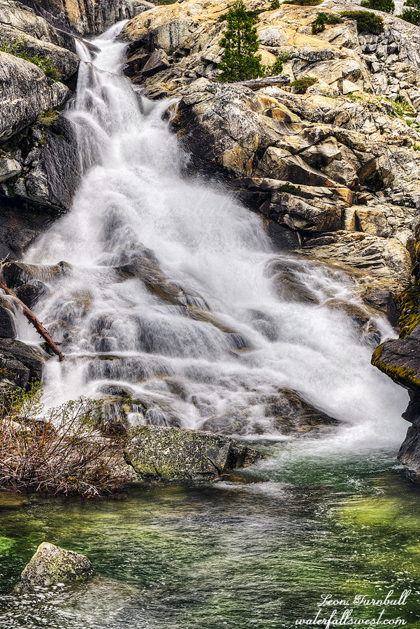
There are three waterfalls up here and along the way I found a beautiful fourth bonus waterfall. I love bonus waterfalls! I found a terrific campsite at the top of the fourth waterfall. Four amazing waterfalls right here, all within view of my campsite (mostly) and all (fairly) easy to get to. I was going to have a fabulous evening.
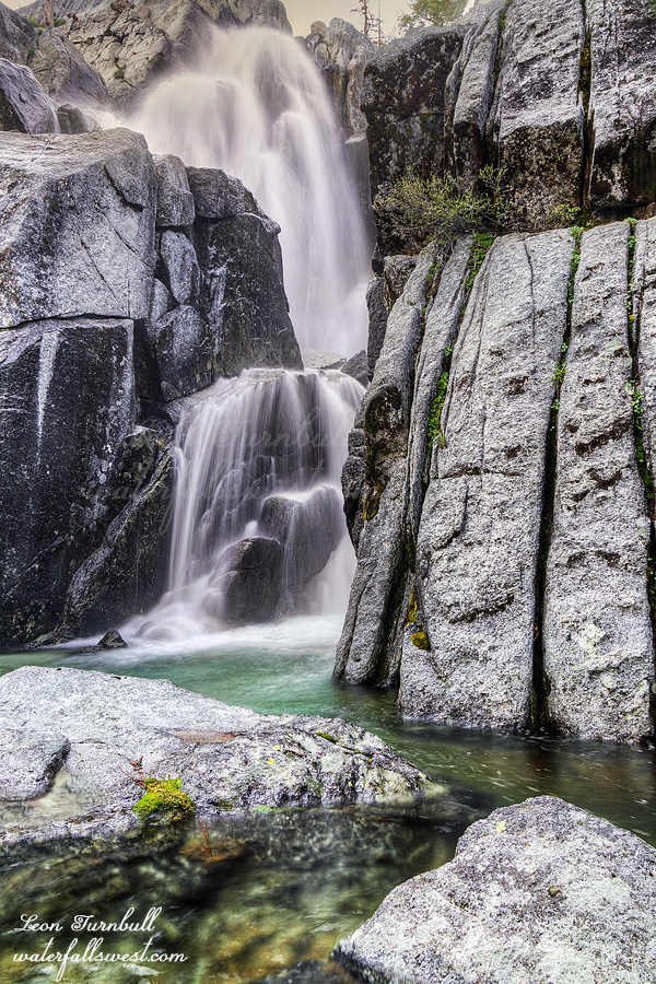
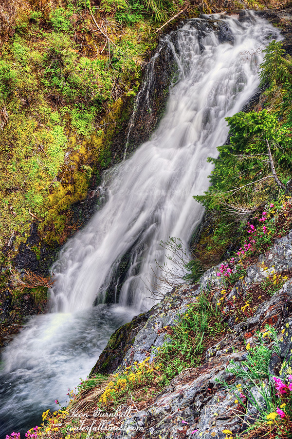
The first of the four waterfalls I went to after dinner was Third Canyon Creek Lakes Falls (pictured here). This one was very fun to get to. Fun Fun Fun. There was a trail going right up to it. I was shocked to find this trail. I did not think anyone would ever come up here, it is so remote. The trail goes down to the creek at the bottom of the falls at which point you need to cross the creek in order to see it. I found a very slick and sloped rock to sit upon while I gingerly set up my tripod to take photos and try to not slip right into the deep creek. Third Canyon Creek Lakes Falls drops 82 ft. off a cliff down into a narrow alcove. It is absolutely stunning.
After this I continued on to the other three waterfalls and then went to bed. It was an amazing first day in the Trinity Alps Wilderness but the next day would be a very different story…
So long story short … yada yada yada … we had to get rid of our Jeep and buy a new vehicle. We bought a new Kia Telluride, shiny dark red. It is sweet and fancy. I am naming her Pepper, short for Dr. Pepper (the can is the same color). Tara does not like this name, although she was the one that suggested it. Go figure. Of course for her first adventure I had to go up Foresthill Road to the New York Canyon area. The last adventure for our old Gator was here. The first and last adventure for our Jeep was here. So the first adventure for our new car will be where? You got it.
I wanted to try to get to the lower falls on West New York Canyon Creek below the main waterfall. I thought I could do it. Huh.
There was still a little bit of snow left at 6600 ft. elevation but not much. Descending down into the canyon there is a lot of brush. My legs got all scratched up. Is it my imagination or is there a lot more brush than before? I was just here last year! I was scared of all the brush. What I mean is I was scared of stepping on a rattlesnake. I have already almost stepped on four of them this year. I have hiked down here a few times before and never given it a second thought but this time I am freaked out of my mind of stepping on a snake. Thankfully the brush gets a lot less the further you go down. It is a 1500 ft. descent.
I got down to the viewpoint of the main waterfall. I thought that if I could just get past the first cliffy part at this spot then it would be a cakewalk. According to the Topo maps it should be pretty easy. Well, I got down past the first part all right. Then I hit a real cliff. No further entry down into the canyon was possible. Dang. I retreated to the main waterfall viewpoint. I had two hours before it would be in good light. I did not want to wait here two hours. I already have a decent shot of this one. I went back up the mountain.
On the way down, there was another waterfall I saw on the eastern branch of the creek. I had not been to it before and it looked like a real nice drop. It was much easier to get down to this one and I got right to the brink of the waterfall. I only had to wait an hour for the sun. I sat down on the rocks and ate my dinner along with the ants and mosquitoes. (actually, there were only a few mosquitoes but I did put on bug spray to keep them away).
The waterfall is 38 ft. high. It is a very lovely cascade and especially nice because there were pretty wildflowers along the edge of the cliff in front of it. I took a few photos from different angles. It took 1.5 hours to climb back up the mountain to my car. It was a fantastic first adventure for Pepper in Tahoe National Forest.