We were headed up to northern California for the weekend to celebrate Christmas with my wife’s family. She went up early so I had to bring the kids with me on Saturday morning. The thing is, I wanted to stop for a hike on the way up north. The problem is, the kids did not want to hike with me.
My son Jadon would literally rather sit in the cold car for three hours than go on a hike. I have failed him miserably. It is very disappointing to me and I don’t understand it. At least Nekoda has a good excuse: she is injured from dancing. She probably would have come hiking otherwise but the problem is that she is ALWAYS injured from dancing. I guess that is just the normal life of a dancer.
So … I was still going to hike. They can sit in the cold car if that is what they want to do. I decided a good hike to do would be Lovejoy Falls in Chico. I just found out about this waterfall last year. It is shocking that I never knew about this waterfall before. It is well marked along a popular trail in a popular park. How could I not know about this one? It is strange. It is on a very small drainage but with all the recent rain I figured that it should be flowing well.
The hike begins with a big 600 ft. descent down into the canyon which I would have to go back up later. Maybe it’s a good thing the kids stayed in the car. They would not have liked hiking back up this! For me though it was no issue and I looked forward to the climb at the end (seriously – but I am a bit strange). Once down at the bottom the trail meanders along the ridge through a beautiful lush forested area to the top of Lovejoy Falls, and then continues down to the bottom of the falls. It was a very peaceful hike. No one else was on the trail. It was a gorgeous day.
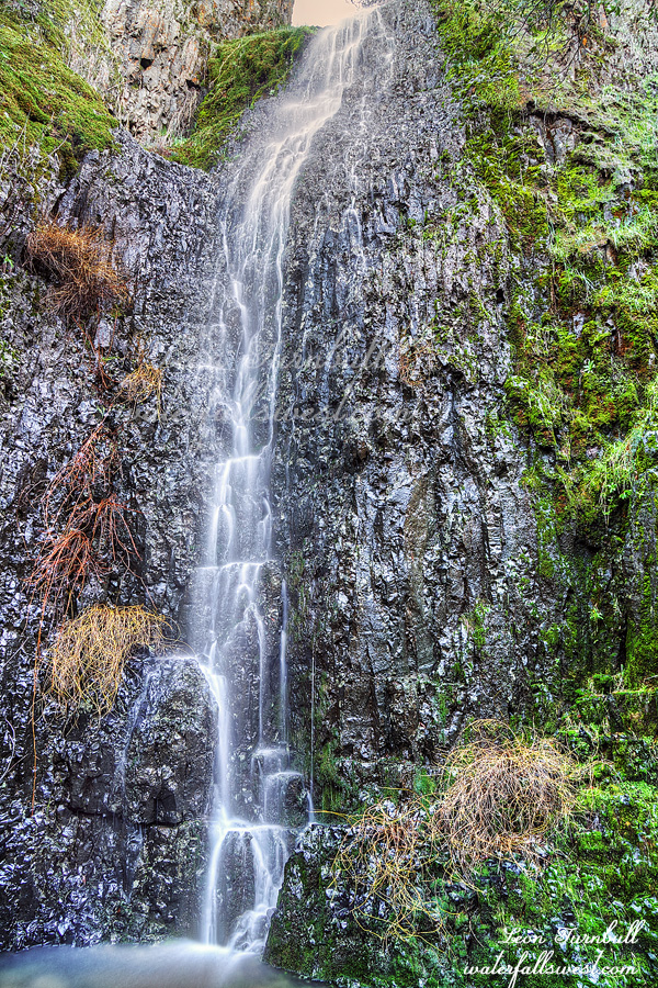
Lovejoy Falls is 51 ft. high dropping off a big cliff into a very small pool. There is a big rock wall you climb up on right in front of the falls which is quite interesting. I thought it would have a lot more flow than it did but nonetheless the waterfall is very pretty. A couple other hikers came up to the falls just as I was leaving but otherwise I saw absolutely no one for the entire hike. It was a beautiful day in Chico and a beautiful hike to Lovejoy Falls.
Posted in Northern CA, Waterfalls by leapin26: December 19, 2021
So it begins. This week we are finally receiving our first big snow storm of the season. Over six feet of snow on the mountains in just a single storm. Wham! This will help our snow pack tremendously though we will still be well below average after this week. Let’s bring it on for the rest of this season. Please!
Speaking of beginnings, we bought a white Jeep Grand Cherokee this week. We named her Yeti. I’m not really sure the name will stick like the Gator but anyway it’s a nice car. I like it. Where should I take her on her first adventure? Foresthill of course! It is my favorite place, it would be a great choice for Yeti’s first time in the mountains. That is not the main reason I went back to Foresthill, however.
I wanted to return to this waterfall because of a couple reasons: I thought it would be flowing really well and I wanted to explore further downstream. Also, after this week the area will be inaccessible until spring. It snowed four inches earlier this last week. The snow levels were very low elevation. The road was very icy and snowy. Yeti’s first time in the snow. She handled it well. I drove up to Tadpole and parked there. Interestingly, the only other car up there that early was a dark green Ford Expedition. Wait, is that the Gator??? No it was not. That car continued up the road to the top of Canada Hill. My plan was to go to West New York Canyon.
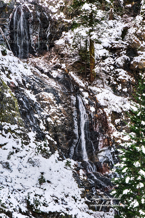
I was walking through 4 inches of snow for the entire hike down to the waterfall viewpoint. There was snow all the way, 1500 ft. below where I started the hike. A couple stupid things: I should have worn my big hiking boots instead of my hiking shoes. My feet were frozen for the whole hike. Secondly, I should have brought my spikes. I did not really need them (fortunately) but it would have been good to have them in case. I was not expecting any snow at all down at the waterfall.
The very last part down to the viewpoint is steep and I had to be careful but it wasn’t too bad. I was not able to explore further. It was far too dangerous to continue because of the snow. Perhaps if there was no snow I could have gotten down. I don’t know but I’m sure I will be back to try sometime in the future. There is definitely another waterfall down there.
The flow in the creek was low and not as nice as I hoped. I think that is because all the precipitation from the last storm fell as snow not rain and the snow is not melting. Still, it was very pretty. The snow around the waterfall was gorgeous. It was a great day in Tahoe National Forest and Yeti agrees.
Posted in Northern Sierra, Waterfalls by leapin26: December 11, 2021
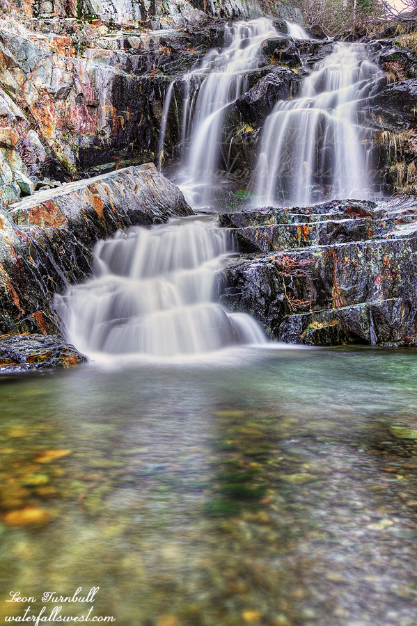
I am calling this one Far Upper Wabena Creek Falls. It is a pretty little thing, 32 ft. high. A little cutie pie. It was surprisingly easy (or not difficult) to get down to this one (and the big waterfall as well). I was expecting a lot of cliffs. There were not any cliffs at all. (if you go the right way – which I did). I was also happy to see the creek still flowing decent. My backup plan was to go down to the river at Palisade Falls, which I really did not want to do. That would have been a hard hike.
Posted in Northern Sierra, Waterfalls by leapin26: December 8, 2021
When I discovered this waterfall on Wabena Creek in summer 2020 it went right to the top of my list for visiting this year. I knew it would be an incredible waterfall. If I could get to it…
The plan was to try to go there in the spring of this year but it just never worked out. I never had a chance to go. I guess it is going to have to be spring of 2022, I thought. However … it is December. We still do not have any snow. It did rain a lot in October. Would Wabena Creek be flowing now? It seemed a bit unlikely but perhaps worth a try anyway. I had a backup plan if I got all the way out there and found the creek was dry.
It was to be the last adventure for Gator. That is the name of our dark green SUV. It is a name that fits the beast perfectly and stuck for 17 years. It is time for her retirement now. I am glad I picked Foresthill for her final outing with me. It is without a doubt our favorite place to go. It is shocking that I can drive up there in December. I have never been able to do that before. As I drove the last 10 miles on the rough dirt road from Robinsons Flat I suppose I even got a little bit emotional. I’m strange. It was a good last drive for her. There was no snow, but there was mud, creek crossings, and steep sections to drive up. I did not put it in 4 wheel drive because she has been having trouble with that in her old age. It was not needed anyway. The only thing missing was a bear sighting. Ah well.
The first order of business was to go to the Far Upper falls. (next post). It is a quick jaunt from the road down to the creek. I could see that the creek was flowing decently. Perfect. This is going to be a great day. It was not difficult to get down to this waterfall, a pretty little 32 ft. drop.
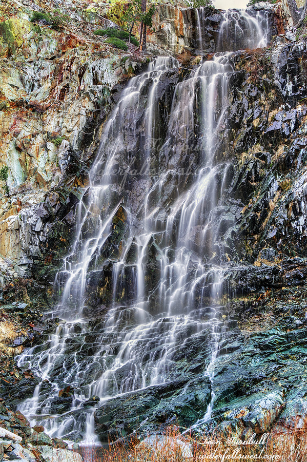
Now I had to climb back up and traverse the ridge down to the big waterfall. Surprisingly there was a path. I think it must be a bear path. I don’t know of any humans that have ever been down here before. How would anyone even know about this waterfall? It has never been documented by anyone (before now). Not even the late Russell Towle made it here as far as I know (and he went everywhere). I am the last adventurer. The path seemed to abruptly end at a wall of thick brush or perhaps it went through it. Must be bear. Now I had to drop straight down to the creek. Would it be too cliffy? As I descended I came to a terrific viewpoint of the big waterfall and I took some photos from there. I was not sure if I’d be able to continue, getting down to the creek and then up to the falls. I definitely had to try. Getting all the way down to the creek was easy enough. No cliffs. No problem. I worked my way upstream to the falls and got blocked out by a mini waterfall but I was not to be outdone. I crossed the creek and climbed up above the cascade on the other side. That was the only obstacle. I made it!
Upper Wabena Creek Falls is absolutely magnificent. 143 ft. high. It is a monster. Being able to stand right at the bottom of this incredible waterfall is so utterly amazing. It was a very awesome day in Tahoe National Forest for the waterfall madman and Gator.
Posted in Northern Sierra, Waterfalls by leapin26: December 5, 2021
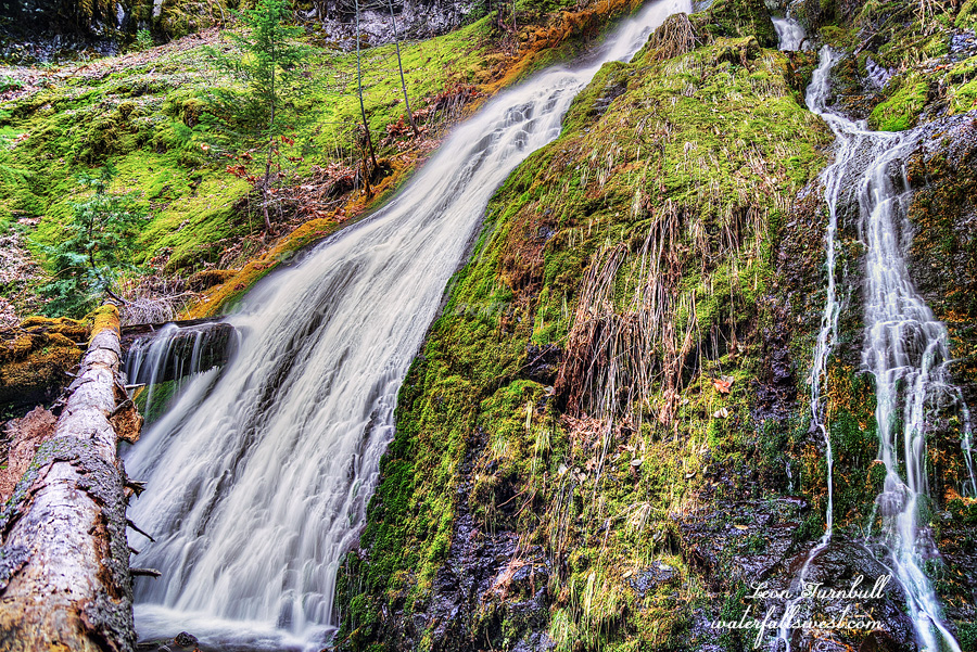
This is Lower West Fork Deep Creek Falls, 55 ft. high.
On my way down from the upper falls I came to the brink of a cliff. A big one. I was at the top of a waterfall which should not be here. The topo map does not indicate that there should be any steep drop here. Indeed according to the map the terrain should be pretty mellow. It was a huge surprise to find this waterfall here. I like surprises but how on earth am I going to get down? I crossed the creek at the top of the falls and traversed along the ridge away from the falls. There was actually a path. Was it human or bear? It led away from the cliff to a spot where I could get down easily enough but then it continued away from the waterfall. I had to get back to the waterfall to photograph it so I left the path and headed straight down to the bottom of the falls. This one reminded me a lot of Russian Gulch Falls on the California coast, complete with the log across the middle of it. It is another beauty.
Posted in Northern CA, Waterfalls by leapin26: December 1, 2021
