DAY 1. THE BIG GAME
Last year I attempted to get down to Big Granite Creek at the confluence with the North Fork American River and failed miserably. Four weeks ago I tried again, going down from Loch Leven Lakes, and failed miserably. (due to the trail being too brushy). Little did I know at the time, I would not have made it even if the trail was not brushy. This last weekend I tried it again, via a different route. And finally, success! Yet … I almost failed again.
I did not go up to Loch Leven Lakes, but started from a different point; it was a long and bumpy dirt road which seemed to take forever, but at least it was drivable. I finally made it to the trailhead. It was June 7 and the temperature was 31 degrees. There was snow in the forecast for the morning. Yes, you heard me correctly. It was cold, and yes it did indeed snow a little on my hike this morning. There was another couple going from here to Loch Leven at the same time (it was very early). We said our hellos and goodbyes, and then I was off and running in a different direction. It is a 3500 ft. descent in elevation down to the river. This is not for the faint of heart. This is the Big Game.
I missed the trail marker. I walked right by it and did not see it. (I only saw where I went wrong on my way back up). I have no idea how I could have missed it, as it was very obvious. The actual trail is right beside a clear cut area, which is what confused me. Nonetheless, I wandered around in the bush for a full hour trying to find the trail. I lost my blue foam sitting pad somewhere during the bushwhack. I was this close to giving up completely, and then I stumbled upon it. Salvation! What a relief. I really really did not want to have to turn around and go home.
Even though I finally found the trail, I was still very unsure how far I could go on it. I have heard it is overgrown and brushy, and on my attempt last year, that was my analysis also. Well, not so. The trail was in perfect condition the entire way down to the river. It is very steep, for certain. Otherwise, it was perfect. Again, I don’t know how I could have missed it on my trip last year. The trail is so obvious! I guess it is only obvious when you are on it. I saw a sign saying that the trail has been cleared by a motorized group. I do not know who or when, but I sincerely thank you, whoever has cleared this trail (it “should be” the Forest Service that maintains it). I honestly don’t know how anyone could ride a motor bike down this trail, however. It is so steep!
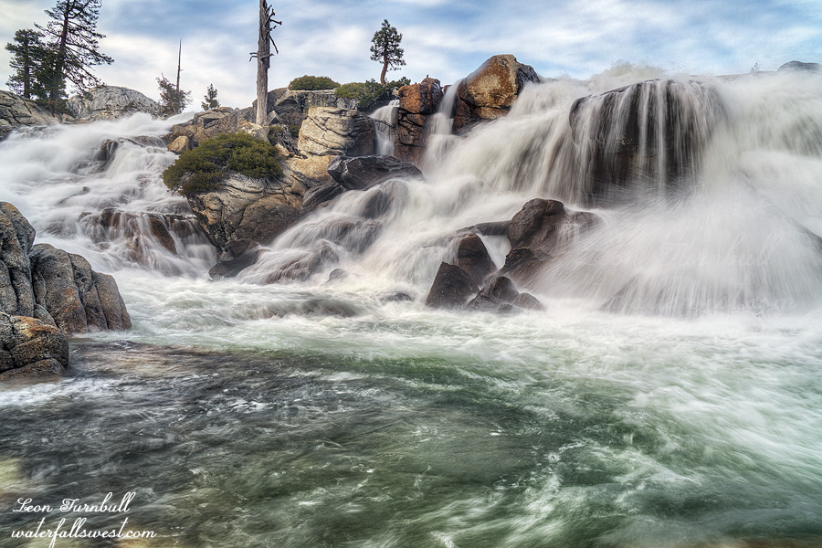
There are two crossings of Big Granite Creek. I expected them to be very easy, perhaps even rock-hoppable. Not so! In fact, the creek was just barely crossable. It was certainly do-able, but the water was up to my knees with a fairly strong pull. The second crossing down at the confluence was more difficult, and up to my thigh. The North Fork American River was flowing at about 380 cfs at the North Fork Dam. I think I could have crossed at a little bit more, perhaps 500, but probably not 600. Four weeks ago, it certainly would have been impossible, had I made it down this far. (so it’s a very good thing I could not find that trail four weeks ago).
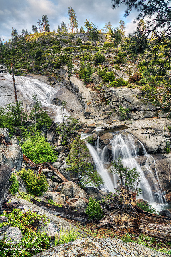
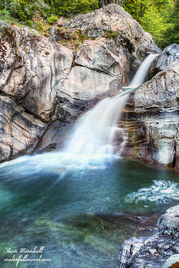
There are no decent campsites on the east side of the creek at the confluence. That meant I had to cross Big Granite again. I was sort of expecting this, but was not sure. The reason the crossing at the confluence is more difficult is because Little Granite Creek joins up with Big Granite after the first crossing. On the west side, however, it is extremely rocky. I was definitely NOT expecting that. There was literally only one small spot to setup my tent. Well, it worked. It was 3PM. I setup camp, ate my dinner, and then set out to photograph the waterfall, which is found right at the confluence.
Big Granite Creek Falls is a beautiful 3 tiered waterfall, about 40 ft. high in total (only two tiers are shown in this photo – in case you are wondering – ha ha). I may have to rename it, however (story on that, tomorrow). In the evening, it started to rain. Thankfully, it did not rain too much and I had a very enjoyable evening.
But the best is yet to come … so stay tuned ….