Firstly, the bad news. Here are the April 1 statistics: snow pack is at 57% of average (northern CA), 58% (central Sierra), 45% (southern Sierra). Rain fall is at 55% (north), 53% (central), 51% (south). Despite what you may have heard, we did NOT have a miracle March. March precipitation was above average (thankfully), but it did not make up very much in the snow pack. So it is going to be a bleak year (as if it wasn’t already). Interestingly, the late March storms added a lot of snow to lower elevations, so despite the low snow pack, you cannot access anything above 5000 ft. elevation right now (if you were even going to go out). Storms are continuing into April, but that will end soon and the snow will start melting quickly and soon be over. Yosemite is closed. 🙁
Secondly, for my hike this past weekend, I need to say that I did not break any rules or orders. I did not interact with a single person the entire weekend. I did not stop anywhere in between my house and the trailhead. I did not put anyone at risk whatsoever, including myself. I should not have to say any of that, and I’m sure 99% person of my readers are good, but … There are two sides, of course, and they are both wrong: On the one hand you have the people who are irresponsible, and don’t care about getting the virus or about spreading it to others. (or they don’t believe they will get it). Then on the other end of the spectrum, you have those living in fear, and they are spreading their fear and hate to everyone else, shaming those who go out hiking (even though they are being completely responsible). At this time in our history, we must be united. We must be helping each other and loving each other. So please everyone, stop spreading hate. Start spreading love.
I had hoped to go to higher elevation this weekend, but the low elevation snow stopped me in my tracks, and I could not get anywhere near the trailhead. I turned around and went to Plan B. This is one of my all time favorite creeks in the North Fork American River drainage. There are no less than seven magnificent waterfalls on this creek. It has been quite a few years since I have been down there. In fact, it has been 11 years since I went all the way down to the river. I’ve been wanting to return for quite some time now, and I’ve been wanting to camp down there so I would have more time. This would be a good weekend to do it.
There were three big problems, of course, and not necessarily in this order: (1) Ticks. This is Tick City. I have been down this trail more than once and had to retreat because the ticks were so bad; they were all over me, and literally forced me back. (2) Poison oak. Nuff said. (3) Crossing the creek. There used to be a bridge over the creek but it is long gone. If the creek is too high, it cannot be crossed (and I have had to retreat because of this also).
I got to the trailhead, and started my hike. It was a beautiful morning. There was a storm coming the next day, and I hoped to get out of the canyon before I got too wet. As you get closer to the creek crossing, you begin to hear the creek although you cannot see it yet and you are high above it. It did not sound very crossable. The North Fork American River was flowing at 800 cfs. In my notes, I anticipated that I should be able to cross the creek if it was 1500 cfs or less, definitely not any more than this. So it should be crossable, but it did not sound crossable.
Eventually, I arrived at the creek crossing. Well, hmmm, … It definitely looked a bit tricky, but it did look crossable. I made it across successfully and without incident. I do think 1500 would be too much, but maybe a little more would be fine. I had my lunch on the other side of the creek on the rocks. From here, things now get much more interesting as the trail descends steeply all the way to the river. Waterfalls galore. Magnificent views galore. Narrow trail. Huge (deathly) dropoffs. Poison oak galore. Ticks galore.
The ticks were actually very manageable. Surprise surprise! They were definitely out, hanging about on the grasses, but they were easily avoidable if you were careful. (and I was careful). The poison oak was a different story. It was all over the place. The urushiol oil was just oozing off the leaves, daring you to get close to it. On the way down, I somehow avoided touching it (thankfully), but on the way back up, I touched it multiple times. I scrubbed myself down when I got home. Hopefully, I do not get the rash.
I was hoping to camp either down at the river (preferably), or at the sixth waterfall (just above the seventh). There was no way to get down to the sixth waterfall that I could see, and there were no places to camp along the river (it was far too rocky). There was literally one small place to set up camp along the cliff, essentially right along the trail, above the river. It was a short walk down to the river from here, and the spot was tight, and uncomfortably close to giant poison oak leaves. It was a little windy here as well, so I had to set up the Zpacks tent much lower than preferable. It would have to do.
I ate my dinner, then went up to see the sixth and seventh waterfalls. I should have gone up to see more waterfalls since I had a lot of time; they were further up the canyon, however, and I had planned to see them in the morning on the way back up. I think that was a big mistake since I had so much time and the weather was so perfect. In the morning, it would be raining. Oh well. I definitely will be back here again.
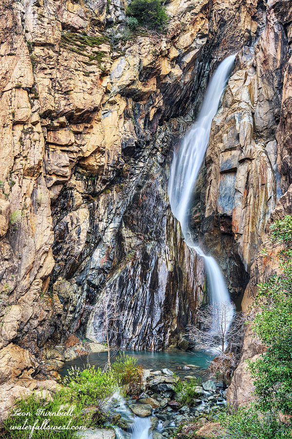
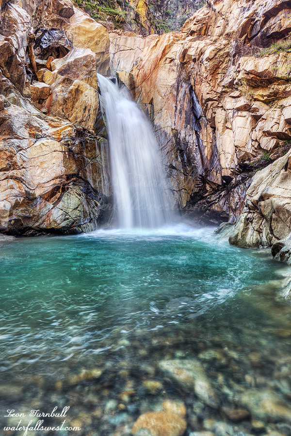
Shown above is the seventh waterfall, 26 ft. high, located right at the confluence with the NF American River. It is a magnificent place. I was camped essentially right near the top of the waterfall. There is a better campsite on the other side, but very deadly to cross the creek above the falls. Not taking any chances on that, I chose my small spot next to the poison oak. I had a good night, listening to the multitudes of birds throughout the canyon. I still wanted to see the Big Waterfall in the morning. Hopefully, before the rain started …