DAY 1. BEAR ALLEY

It was my last backpacking trip of the season. I suppose that is not saying much because October 1 marks the start of the new season! The new waterfall season that is (the only season that matters). Indeed, we may have our first storm of the season next week. Anyhow, it will no doubt be awhile before my next backpacking trip. Winter is coming. The weather has been splendid the entire month of September (for backpacking), and this was my third trip of the month. This time around: Carson Iceberg Wilderness. I think I have hiked in this Wilderness before, but not backpacked. My goal: to reach mysterious Carson Falls. I have only seen a couple photos of this waterfall before, and they were not good ones. They made it seem like Carson Falls is pretty much un-viewable, and I would not have been surprised to find it that way. Instead, I found glory. But before that…

I arrived at the trailhead on the Eastern Sierra Nevada side, and was hiking by 8:45am. A tad late, but not bad. A sign at the trailhead indicated that bears in this area are habituated to humans, un-afraid, and eager to get your food by all possible means. That is not a good sign.

After climbing up 500 ft. to the top of a ridge, the views open up tremendously. The landscape is magnificent. The fall colors are already starting to shine (it is still very early in the Fall season, but they are already close to peak). The scenery is much different here than say, Ansel Adams Wilderness, but still astoundingly beautiful. The beautiful yellow and orange Aspens really upped the ante of the beauty. It was stunning, and I took a lot of video, which thus slowed my pace considerably, but I was not too concerned. Until…

Once I crossed Silver King Creek, the trail to Carson Falls heads off westwards. I did not see any trail westwards. According to my USGS map, it should be immediate after crossing the creek. Not so. I bushwhacked a bit, eventually getting back on the proper trail. I realized I should have continued up Silver King Creek a bit more to the marked trail junction, but how would I know that based on my map. From here, the trail goes all the way to the East Fork Carson River. Again, my map showed a trail down to Soda Springs Ranger station along the river, but there was no such trail. I continued on the main (obvious) trail, but this new route would add a lot of mileage to my trip that was not planned. Finally down at river level, I stopped at Poison Creek to filter some water. Thankfully, the water was clear and not poisonous – if it was poisonous, my Sawyer squeeze handled it nicely. Here, I met the only other backpacker I saw all weekend (except I did see some horseback riders the next day). He was an older guy, he was not very talkative, but he said he came from Wolf Creek and would be camping somewhere along the East Carson River. I think it is quite a trek coming from Wolf Creek, so he must be doing good, and he was a lot older than the geezer writing this blog.

After crossing the East Fork Carson River – which I rock hopped across – though it was a bit hard to do that – the trail was once again lost to my senses. Eventually, I found it again and continued up the river … until I lost it again … until I then found it again. As you may be able to tell, the trail is not all that well traveled. Not many people hike this section of the trail, I think especially from Soda Springs to Carson Falls. Once on the trail, it was easy to follow. It is just those few times where it was very indistinct or missing. In other words, this section took much longer to hike than anticipated. In addition to this…

There is a 2 mile section along the river here which we shall affectionately call “Bear Alley”. I saw more bear scat along the trail here than I have seen in my entire life combined. Maybe not quite. If not, then it is very close. I am not kidding. Every 20 paces, bear scat. Every 10 paces, more bear scat. The closer I got to Carson Falls, the more prevalent it became. Every 5 paces, more bear scat. Most of it was not fresh, but some of it certainly was. This was not made by one bear. A family of bears. Angry momma, and her five adorable children. Let’s not forget perturbed papa bear. And probably grumpy grandpa bear too. You would think that with all the bear scat, I would see some bears on this trip. No such luck. I was looking for them. I was hoping to see one, but I did not see any bears, or any other wildlife either. I think I saw an eagle, but it was too far away to be certain. Nothing else was seen (not counting birds and squirrels).

As I approached closer to Carson Falls, the trail once again disappeared. Actually, it just seemed to end very abruptly and succinctly. Now what? It was late in the day, too late to go back. There must be a way to get over to Carson Falls. I started to bushwhack over towards it. Nothing doing. After a long bit of searching, I finally did find the proper trail over to it. It was very easy to miss it (I did miss it!), and again, my map showed something very different than actuality.

I hoped that there would be a campsite close to Carson Falls with access to the river, but I was not certain. It seemed pretty cliffy in that area, but fortunately, I found a great spot a short distance above the falls, and yes, one and only one spot where I could get down to the river. No bear scat in the immediate vicinity of the campsite. Awesome. It was 3:30pm when I arrived. I had hoped to get here by 12:30pm, and then do another hike in the afternoon up to Golden Canyon. There was now no time for that. I was way too tired and it was way too late. I wisely just stayed at Carson Falls for the rest of the afternoon and evening.

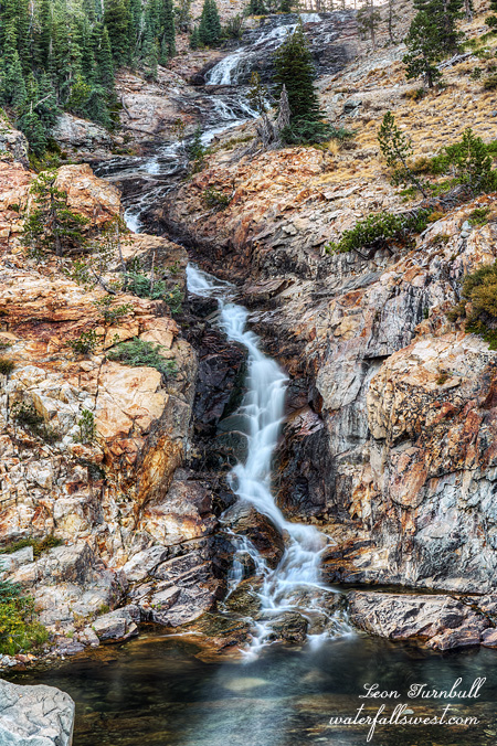
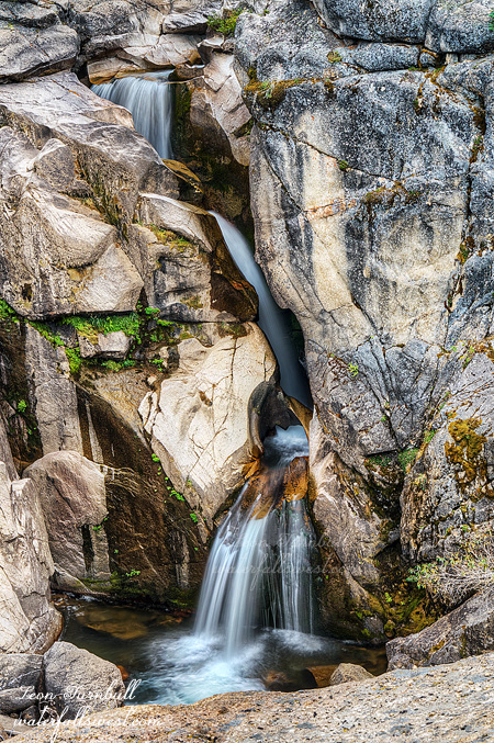
After setting up camp and making dinner, I proceeded down to the waterfall. There was a steep path to the bottom, and I started down it, but quickly balked. This was way too steep and dangerous. With a rope, it possibly would have been do-able, but I had no rope. I did not think I’d be able to see much from the bottom anyway. Instead, I climbed up onto a large protruding cliff overlook. This was not “too dangerous” except for the big huge drop-offs, but it provided a glorious view of Carson Falls, and I could see all three magnificent tiers of the waterfall (mostly). I really really really enjoyed this waterfall. It is very beautiful. At higher flows, it would be even more spectacular, but in late September it was still glorious.

No Comments

DAY 3. THE DARK SIDE OF THE MOON

I was very tired from the previous day’s hiking, but I did not sleep. I have no idea why I could not sleep. I should have been plenty tired. It was not cold (indeed, I was 1000 ft. higher in elevation and it was warmer than the first night). Well, I got up at 4AM, packed up my gear, and started my hike. It was very dark. There was no moon. There were plenty of stars.

The first part of this hike, there is no trail. The route goes through the (dark) woods, and across a (dark) meadow. Perfect habitat for wild animals. The previous night I saw many deer in this area. Where there are deer, there are mountain lions. I also saw fresh bear scat. I whistled loudly as I walked through this area. When I hike (in the dark), I always whistle the “ru ku ku” song from SCTV. If you know what that is, you are awesome (it’s a Canadian thing). Once I got on the actual trail, it was a bit less nerve wracking, but it was still dark and ominous. Back down around Ediza Lake, some people had put up their tents right beside the trail (or right in the middle of the trail in one case), so I had to walk right through their camping area, hoping not to wake them and freak them out.

I arrived down at Shadow Creek Falls (pictured here) (40 ft.) at sunrise. I was right on time. It is a gorgeous waterfall, and Shadow Creek (as I said already) was flowing very strong for so late in the year. There were some people down here at the base of the falls eating breakfast. This is not a legal place to camp, and I’m not sure if they were camping here or just eating breakfast here as they had all their gear packed up already. They were friendly, considering as I was disturbing their breakfast to photograph the waterfall. I did not talk to them much, I was in a hurry to photograph the falls and get going to the next one. As it is, I barely made it down to Shadow Lake Falls, the last waterfall on my journey. I only had about 2 minutes to photograph it before the sun got on it.

Now finally I could relax. I ate my breakfast at the viewpoint to Shadow Lake Falls. I still had a very long hike ahead of me. It was another 7 miles back to my vehicle (12 total for the day). It was very tiring, and I was beat, even  thought it was mostly downhill, and once I got down to the river level it was not all that majestically scenic any longer (compared to what I had been hiking through). I think the previous day really wore me out, and I was extra tired from not getting any sleep. I tried to cut off 1 mile of the hike by hiking on the road for the last little bit, but that was a huge mistake. Hiking on the pavement was very hard on my feet, and I do not even think I saved a half mile of hiking, let alone 1 mile of hiking. I finally made it back to my car at 11:30am. I drove up to John’s Pizza Works in Mammoth Lakes for lunch, then made the long drive home. At least the highway was now open. I slept well in my bed that night. It was an awesome 3 days in the Ansel Adams Wilderness.

2 Comments

DAY 2. THE WALL OF DEATH

I took my time in the morning, slept in a bit, ate breakfast and drank coffee. I had a tough day ahead of me.

I hiked up to Minaret Lake and found another new waterfall at the outlet, about 60 ft. high. Surprise! It was in the sun but I still took a photo of it. If I had known this was here, I probably could have gotten to it in good lighting. I studied all this area on Google Earth, but did not see this waterfall. Minaret Lake was gorgeous, as expected.

From here I had to climb the monstrous cliffs above the lake and over the pass to get to the other side. There is no trail. I had read there was a route that people used. I read it was steep. I read it was very steep. But it was not too difficult. I made it to the top. 10,300 ft. in elevation. I thought that would be the most difficult part of the hike today. Wrong. I went down to Cecile Lake and ate my lunch.

I thought the trek from Cecile Lake down to Iceberg Lake would be a piece of cake. There is an established trail, you can even see it on Google Earth. Nope. It was very steep, it was very treacherous, the ground and rocks were very loose and unstable. I had to slide down on my butt in the dirt a few times, and be extremely cautious as I descended. If you fell, you would end up allthe way to the bottom where there was a big snow field at lake level. A soft landing? Once down the steepest section, you are not done yet. You have to traverse over a huge talus slide to the other end of Iceberg Lake. The rocks are sometimes shifting, it is very slow going. One hiker I passed called this the Wall of Death. I thought it was a very appropriate description. It took a very long time.

Finally I arrived at the end of Iceberg Lake. There was no shade here, but I found a little bit behind a rock and rested. The hard part (the Wall of Death) was behind me. The rest of the hike would be easy.

As I hiked down to Ediza Lake, I noticed a large waterfall at the inlet to the lake. Another surprise. I had not known about this waterfall either, and this one looked like a very good one. I decided to change my plan. Initially I was going to camp up at Nydiver Lakes, but now I would camp at Ediza Lake and close to this waterfall, or better yet, at the waterfall.

Ediza Lake is supposed to be the prettiest of all the lakes in this area. Everyone seems to say this. It was certainly pretty, but no prettier than Minaret, Cecile, Iceberg, or Shadow Lakes. They were all equally gorgeous in my view. But Ediza Lake is by far the most popular lake to camp at, and there were a lot of people here already and it was still early. I prefer to camp in secluded spots with no one else around me. I figured there would not be anyone at the waterfall, if I could get up to it, and and if I could find a campsite there. It is a bit of a climb from Ediza Lake up to the falls, but not too difficult. There were not really any good options for camping there, but I found one small spot to put my tent. Not too shabby.

After dinner, I decided to go on an evening hike. I still hoped to get to the Nydiver Lakes waterfalls. However, I found that creek completely dry. I was not expecting much for that creek, but I did not think it would be all dried up. Instead, I went down to the Upper Shadow Creek Falls and photographed that waterfall (30 ft.). It was a little far to hike considering how tired I already was, but I guess it was worth it. Shadow Creek was flowing surprisingly strong for this late in the year. It is a glacier fed creek, so perhaps that is the reason (but so is Minaret Creek and that had much less flow). I hiked back to camp, arriving just before dark, and photographed the waterfall at my campsite (shown here), a marvelous 40 ft. high falls. I slumped into my tent and to bed.

No Comments

DAY 1. TAKE IT EASY

I snagged a hard to get permit for Minaret Lake in the Ansel Adams Wilderness, a place I have wanted to go for a long time. My plan was to photograph Upper Minaret Falls in the evening, then hike up to the lake afterwards. However, it is a tough climb from the falls to the lake, and I probably would not make it there by sunset. By the time I got up there, it would be dark, and there would not be any good camping spots left as it is a popular place to camp, plus with no clouds in the forecast, there would not be much of a sunset at the lake anyway. A better option and a much easier option would be to just camp at the upper falls, and go up to the lake in the morning. Take it easy. Don’t let the sound of your own wheels make you crazy.

When I left the house, Hwy 395 was closed due to the Boot Fire, which was burning on both sides of the highway. Hwy 108 was also closed. Going through Yosemite to the Eastern Sierra would take much much longer. The official detour when through Nevada. It probably only added a half hour to my drive, but the speed limit is slower in Nevada. I heard from someone that the Nevada highway patrol like to pull over those speedy Californians, so I made sure not to speed (and I did see one person pulled over along the way).

I finally arrived at Mammoth Lakes, picked up my permit, and started hiking by 10am. The first section is on the John Muir Trail, and I saw many JMT hikers coming down into Reds Meadow. I think I gave one of them bad directions. I’m sorry about that. However, if you are a through hiker (or any type of hiker), you should know where you are going. I don’t think I would ever want to hike the JMT. It is just not my cup of tea. Most certainly, I would never hike the PCT. These through hikers just whip through the trail as fast as they can, and they miss seeing half of the great sites or more. I would much rather hike a short portion of it and see all the great sites (ie. ALL THE WATERFALLS) in that area. I have been thinking recently, however, that I might want to hike the entire High Sierra Trail; that one might work for me, but even so, I think everyone hiking that trail misses seeing at least half the waterfalls. I might rather just do a short section of that trail as well. Next year, perhaps.

After I got off the JMT section, I did not see anyone else on the trail up to the waterfall (I did see others going up to Minaret Lake later). I found a perfect campsite near the bottom of the falls. The waterfall was flowing decent, better than I expected for so late in the year. It was not great, but not bad. It was a beautiful spot.

However … as soon as I arrived at the camp, I smelled smoke in the air. I did not think there were any fires in the area. There had not been any smoke at all until I got to this one location at the waterfall. Was this a new fire? Did some idiot leave an illegal campfire unattended? I checked all around but I saw nothing and no one. I just prayed there were no new fires and I would not get burned to a crisp while I slept. Everyone (including myself) is too paranoid this year because of all the fires. A little smoke freaks everyone out (including myself). As it turned out, I think the smoke was from the Lions Fire, but it was strange because it was only in this one little area.

I had my dinner, relaxed for a long time waiting for the sun to go down, and texted my wife (there was cell service here). In the evening I went up to photograph the upper falls (shown here), and another waterfall I discovered close by as well. It was a glorious day.

No Comments

BOOM BOOM BOLAM

It was a stressful week, and I was so very much looking forward to getting out for an overnight backpack trip on Mount Shasta on Labor Day weekend. But where would I go? Could I even do it? The smoke from fires has been particularly bad up north. Would it be too unhealthy to hike? Would the creeks on Shasta even be flowing? I had no idea. I called the Ranger station in Mt Shasta. They had no idea. Isn’t it their job to know these things?

It has not been hot enough recently. Yes, you heard me correctly. July was hot. The first part of August was hot. But the last couple weeks have been very cool. Too cool in fact. The glaciers on Shasta would not be melting very much right now. Thus I was concerned that the waterfalls would not be flowing any more for this year.

As I drove north and passed Redding, all of a sudden the smoke in the sky became horrendous. This was from the Hirz Fire. The sky was ominous. I could see the orange glow from the fire above the mountains to the east. If it was this bad at Shasta, I could forget about hiking. However, as I got closer to Shasta, the smoke dissipated and the sky became much clearer. Things were looking up. But what about the creeks? I stopped at the Whitney Creek crossing along the highway to check it out. The creek was flowing. Not super great mind you, but it was flowing. It was early morning, so it would be much better in the afternoon also. But if there is water at the Whitney Creek crossing, does that mean Bolam Creek will be flowing also? Or just Whitney? (the two creeks join together before the highway) I have seen Bolam completely dry when Whitney flows. And I have seen Bolam flowing well when Whitney is just a trickle. So what would it be like today? The only way to find this out is to hike all the way up to Bolam Creek as I had originally planned.

I have hiked up to Bolam Creek Falls before, but did not get to the upper or middle falls. It was a killer hike just to the lower falls, and I had no energy or time to continue up the mountain. This time around, I planned a different route. A much easier route, and I would be camping at Bolam Creek as well. I would have plenty of time. It was going to be glorious.

It was a beautiful day. I was feeling so refreshed as I started this hike, but my pack was very heavy. I was carrying 3 1/2 L of water, which should be enough (hopefully) to get me up there and back. I was not certain what the water situation would be up at Bolam Creek or if it would even be flowing, or if it was flowing could I even get down to it? If you look at Google Earth it does not look possible to get down to creek level. The canyon is seriously steep. So that meant I had better take enough water with me to be safe and not sorry.

The trail starts out well for the first 3 1/2 miles. It is well-traveled and a gentle grade, climbing up 1500 feet of elevation. 99% of the people using this trail are summiting Mount Shasta or trying to anyway. But not me. I am looking for waterfalls. So when the trail ends at the point where the climbers go upwards and onwards, I needed to go cross country over to Bolam creek. It was fairly easy going.

The geology on this side of Mount Shasta is fascinating. I crossed over a number of very old and very dry drainages. These are not marked on any maps. They looked to be volcanic, or glacial, or both. At least a couple for certain were obviously glacial. Glaciers that have long since disappeared, probably hundreds of years before USGS made its topographic maps. It seems to me that some people forget that glaciers have been melting pretty much continually since the last ice age, thousands of years ago. If they are continually melting, then they will eventually all disappear, right? Are they melting faster now? Perhaps they are, but it should not be a surprise to anyone that glaciers are melting. On Mount Shasta, the Coquette Creek drainage is dead (very sadly). I declared it dead two years ago after I came up to visit Bolam Falls. I do not think this waterfall has flowed significantly or at all in over 10 years. What a shame. However, it is not surprising. There is not enough glacier above to melt into this drainage anymore. I would pay a lot of money to travel back in time and see Coquette Falls flowing as it once did. But the Bolam Creek drainage still flows.

I descended down into the Coquette drainage, the first real steep section of my hike (which I would have to come back up the next day), crossed it at the dry waterfall and made my way over to Upper Bolam Creek Falls. There was a perfect campsite right beside the waterfall viewpoint, with a view of Mount Shasta and the waterfall in one shot. What a perfect place. I was so happy. I set up camp, had my dinner, then decided what to do next. I had thoughts of crossing over Bolam Creek to Whitney Creek, but I could see no way across. The canyon was crazy steep on both sides. I decided to just stay at Bolam and I’m glad I did.

In the evening I went down or tried to get down the Coquette drainage to get to the base of Bolam Falls, but it was too steep, the ground was very unstable and crumbly. Nonetheless, I did find a path over to it, after I had almost given up. It was awesome to be up close to this marvelous 80 ft. high waterfall (pictured here above). After this I climbed back up, got down to the middle falls (which was crazy steep and dangerous- but I managed), and then photographed the upper Falls from top of the ridge.

I was now down to a half liter of water. I still had found no way to get down to the creek level at any place. The creek was also flowing incredibly dirty and it was not really drinkable. So what would I do? A half liter would not get me back to my car. I went to sleep, very dirty, and very tired. In the morning I decided I’d have to get down to the creek. I found a way, and filtered some water. The creek flow was much lower in the morning, and also a lot cleaner as well. Now I had plenty, and even enough to enjoy a cup of coffee with my breakfast. It was a beautiful morning, and I was feeling terrific. After breakfast, I packed up the gear and headed back up the hill (and then entirely downhill after that initial tough ascent from Coquette). It was a fantastic couple of days in the Shasta Wilderness.


No Comments