REAL LIFE FAIRY TALE

December is the first month of winter, and so it is the time when we officially start measuring the snow pack in California. As of January 1, things are not looking good: The rainfall is at 65% of average for Northern CA, 37% (Central CA), and 22% (Southern CA). The snowpack is at 24% of average (North), 33% (Central), and 23% (South). At first I was not too concerned about this awful dry spell we had in December. We had a decent November and it looked like the pattern was going to change to a wet January. However, now it looks like the ridge will be building back into the west coast in January as of next week, and that means we are headed for another dry spell. This is really bad news. Hopefully this time, it will not be a long one. We need to pray for much more snow and rain in California, and soon.

We headed up to Canada at Christmas to visit my family in Cranbrook BC. Usually we go to my mom’s in Rossland, which has the best ski hill in the world (I am biased), but this year we went to Cranbrook where my sister lives, and we skied in Kimberley instead. It was COLD! At the beginning of the week, the temperature was around -15 to -20 Celsius. That is about -5 Fahrenheit for my American friends. That is too cold to ski or do much of anything. However, my kids did go up for a couple rounds on the ski hill anyway, and it warmed up (slightly) later in the week.

As for all the waterfalls? Well, they were completely frozen of course. I was not surprised. Nonetheless, my wife and I drove to Fernie for one day, and we went on a snowshoe hike to Fairy Creek Falls, which I had not been to before.

There was about 4 inches of fresh snow, so we got out our snowshoes for the easy hike. We could have hiked in our boots, but there were some spots that were deeper, so I am glad we opted for the snowshoes. The hike starts off with a very steep hill to climb. My wife was not amused, and wondered what I was getting her into. I had no idea, but she did not believe me. I do not have Canadian maps on my GPS, so I really had no idea about the terrain, but from what I had read, I knew it had to be an easy hike, and only about 1 mile in length. It was actually 1.4 miles, and after the initial climb, the terrain leveled out and the rest of the hike was fairly easy.

It was very beautiful as well, hiking through the forest in the fresh snow. We read signs, however, that Fernie is in the process of developing this entire area and putting houses in here. This would be incredibly awful and it would ruin this hike entirely. Instead of hiking through a gorgeous forest, you will be hiking past many houses. Residents of Fernie should be very upset about this in my opinion.

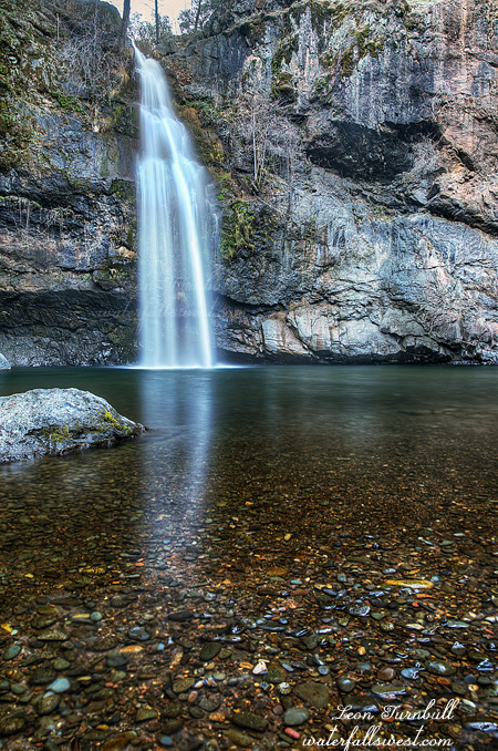
Anyway, we finally came to the waterfall. It was very pretty, and it was not entirely frozen as I expected it to be. It was gorgeous in the snow, a true Fairyland, and very much living up to its real name, a real life Fairy Tale. It was a bit tricky getting right up to the bottom of the falls in the snow, as it was steep and slippery, but I did go up close to it. The best views, however, were from further back, up on the hillside (where I took this photo from).

On the way back, we saw a few hikers coming up the trail. None of them wearing snowshoes. They probably thought we were some weird Californians, but my answer to that is that we padded down the snow for them so they would not need snowshoes. They should have thanked us. Am I right?

P.S. If you are wondering about my title to this blog post, it is the name of an old song which I love, by Plumb. It has nothing to do with waterfalls, but look it up if you are interested in the song. You will like it.

No Comments

MILL CREEK FALLS

My latest Waterfall Madman video release is here! This is a snowshoe hike to Mill Creek Falls in Lassen Volcanic National Park with my wife. Mill Creek Falls is one of the taller waterfalls in Lassen Volcanic Natl Park CA, 69 ft. high, and is arguably the nicest waterfall in the park. It was fun and adventurous, and a bit difficult. Please enjoy watching (in HD).

Please like, share, and subscribe to my channel. Thank you.
Would you like a special shout-out in my next video? Here’s what you need to do:
1. Share the video (before Dec 31)
2. Subscribe to my channel (if you haven’t already)
3. Leave me a comment (so I know who to credit)

2 Comments

BOOM!

It has been four years since I’ve been to see my old friend, Feather Falls. I figured it was well past time to make a visit.

Why? Well one reason was I wanted to make a video of the Feather Falls hike. I accomplished this successfully, and it will be ready for viewing sometime in January. I started making videos again, and this time they are new and exciting and high quality, so if you have not seen them yet, please check them out and follow waterfallmadman on youtube. I appreciate the support. I have a brand new one being released next weekend. Do not miss it!

So anyhow, I arrived at the Feather Falls trailhead before sunrise. There were some people camping here (in the campground). The weird thing is that one of the cars had Christmas lights on (inside it). It kind of freaked me out seeing that so early in the morning. I am kidding. Sort of. I was not expecting to see anyone there. Definitely not that.

I started my hike in the dark. I had a couple hours to make it to the waterfall before the sun would get to it. I had plenty of time, but not enough to dilly daddle too much. I hiked quickly.

Frey Creek had pretty good flow in it. This is a good sign and made me happy. Even though we are in a long dry spell and even though we have not had a lot of rain yet this winter, the waterfalls are flowing already. They did not need very much precipitation to get started this winter. I think that a lot of people do not realize this (that the waterfalls are flowing already). In some areas, though, such as the coast, they are going to need a lot more water of course. I pray that this dry spell ends soon and we have a good winter.

One thing that did not make me happy: the ticks!!! They were everywhere, just dripping off the grasses along the trail. This is the second hike already this winter where I’ve seen a lot of ticks. It is only early December. They should not even be out yet! I am predicting this is going to be a horrendous year for ticks. I think it is because of the very wet winter we had last year, due to that, the ticks are going to be awful this year. Last year, remember, the ticks were not very bad at all. This is my theory. Whatever the reason, they are already bad bad bad this year and I do not like it. The good thing is that the Feather Falls trail is very wide and it was mostly easy to avoid getting lurched upon by the little buggers.

Before too long, I arrived at the Feather Falls viewpoint. The waterfall was booming! Well, perhaps not exactly booming, but it was flowing strong and it was awesome. Feather Falls never fails to disappoint. It is truly magnificent. Of course we all know by now the true height of Feather Falls, that it is 410 ft. high and not 640 ft. high. Of course we all know who is responsible for that correct measurement. I do not really see anyone using the old incorrect height anymore, but when I do see people using the correct height, they never credit yours truly. Oh cry me a river, I know. Anyway, I wanted to re-measure the height this time around. I only measured it the one time and there is some error involved when doing this. I am happy to report that my new measurement was very close to 410 ft., in fact it was so close that I am confident to keep the 410 ft. figure as the true height of the waterfall.

I thought about trying to get down to the bottom of the waterfall. That is all. I just thought about it. The main thing that stopped me from trying: the poison oak looked horrendous down there. I just did not feel like dealing with the oak today. My friend Rob the mountain goat almost made it down to the bottom awhile ago, but was stopped mostly by poison oak so I knew it would be bad the entire 410 ft. to the bottom. I could see it would be bad, so that is enough thinking about that. I went to the top of the waterfall instead and took a timeout inside the cage at the brink of the falls. It really is a bit crazy getting into the cage. The rock is smooth and very slippery. One little missed step and you are a goner. People have gone bye bye here in the past. I actually did slip on it one time, but I was already inside the case and so was in a safe spot. Still, just that little slip freaks you out. I still had to climb back out of the cage afterwards. And then I did it all a second time with my video camera. Don’t even consider trying this stunt if the rocks are at all wet.

I hiked back to the trail loop junction and sat down on the bench and ate my lunch. As I was sitting there eating, I heard the sound of a plane. It got louder and louder and louder and louder. I stood up, looking around for it. Then I saw it. A jet screamed by, flying very low, and clearly faster than the speed of sound. Boom! I heard the sonic boom as it went overhead. It was so very loud! Wow. It seemed to me that it was flying straight up the Fall River Canyon, and right over Feather Falls. It would have been absolutely awesome to have been at the overlook at the time it flew over, although perhaps it would have destroyed my ear drums. Nonetheless, I regret not eating my lunch at the overlook. Ah well.


No Comments

MILL CREEK FALLS PREVIEW

New video release in 1 week! Are you ready?

No Comments

SHOT IN THE DARK

I have been wanting to get up to the High Lakes area in Lassen NF for a long time. There are quite a few waterfalls in this area. The problem is: it is a LONG DRIVE AWAY. Essentially, you drive to the other side of the Earth, and then a little more. Also, you need to go when it is a cloudy day for waterfall photography purposes, and also when the road is open (that basically means summer for the most part, and there are no cloudy days in summer).

Well it was going to be a cloudy day on Saturday, and it seemed like as good a day as any to try this long drive. I was really not sure about the road, however. You have to drive up to 6600 ft. elevation, there would surely be snow, but how much? There is no information about the road that you can look up beforehand, thus I did have a backup plan if I could not drive up there. Also I was not sure if the waterfalls would even be flowing up there. This whole hike was just a big shot in the dark. Nonetheless, I still wanted to try it.

The road to the High Lakes area is EXTREMELY ROUGH. There were a couple spots that were very sketchy driving my SUV past. I DID NOT LIKE IT. I was definitely worried about driving back down afterwards. My next car is surely going to have more clearance. Have I said that before? There was no snow until the last 100 or 200 feet. I almost bottomed out, indeed I could hear the snow scraping the bottom of the car, but it was just slight, and I was able to continue driving up to the trailhead. I made it up there. Now what?

My plan was to do a big huge loop to see all the waterfalls up in this area. It would be an all day affair. However, this plan was soon to change. I started out with a hike to Morris Lake. There was snow on the ground, and it was icy. The weather was brisk and refreshing. I saw quite a few bear tracks in the snow along the way, some of which seemed fairly fresh.

This is a popular OHV area, and even in the winter, I saw many tire tracks on the roads. I expected to see quite a few off roaders up here, but I saw no one the entire day. That is, until I was almost finished my hike. I did see a couple groups at the end, just up for the day. The road is crazy rough past where I parked, huge boulders to negotiate; I don’t know how anyone could drive a Jeep on that road, but they do. I just wish they could also learn how to pack out their trash. Is it really so complicated? I picked up quite a bit of garbage on my hike. So annoying.

Anyway, from the first junction, it is supposedly 6 miles round trip to the waterfall.  I figured it would be quick and painless, but it was actually probably 8 miles and it was a much much tougher hike than anticipated, with about 1100 ft. elevation loss (which I would have to hike back up). Despite the elevation loss, the snow continued on the road and “trail” all the way down to the waterfalls. This was worrisome because there is a very steep descent off trail down to the falls. That made for a very sketchy hike on cliffy terrain. Could I make it down? In addition to this, the brush is crazy brush. It was not manzanita, I’m not sure what it was, but it was just as bad as manzanita. I was thick in it, and could see no light at the end of the tunnel. I almost turned back, but I persevered, and I finally got through it and then the rest of the way down was not too bad. I came to the first waterfall.

The first waterfall is a pretty darn nice one in its own right, and is 43 ft. high (that will be my next post). From here you can tell there is a huge waterfall just below you, but you cannot see it. You are standing on the brink of a monster cliff with no way to get down, and no way to see the falls. Well, I thought, if I could get over to the next ridge and down, I would be right in front of the waterfall and have a grand view of the thing. The trouble was twofold: First, it looked to be very cliffy on the next ridge, and there was snow on it, so it looked potentially impossible to get down it. Second, there was a huge ravine between the ridge and myself, so how would I possibly cross it? Well, I worked my way over and I saw a way to cross the ravine. With snow on it, it was a bit tricky, and I slipped once. Thankfully, I was holding onto some tree branches, otherwise I probably would have slid all the way to the bottom of the ravine. No joke. I got across onto the ridge. It actually did not look too steep or cliffy at all, and even with snow, it was not difficult to get down it. All the way to the viewpoint directly across from the waterfall. Glorious waterfall. 151 ft. high magnificent waterfall, and flowing fairly well this early in the winter too. The views down the canyon were absolutely breathtaking. What an amazing place. I have never seen any photos of these waterfalls before. Perhaps people have been down to them, but they have not been documented by anyone before waterfallswest.com.

It was already noon. I ate my lunch at the viewpoint. Now I had to climb back up the mountain. 1200 ft. back up. As you can imagine, it was a very tough climb out. I realized there was no possible way I could hike to the other waterfalls. Even if I was not so tired (and I was), it was now too late. I would have been hiking back in the dark for certain had I continued on as originally planned. As it was I just got back to the car less than an hour before sunset. I will have to come back here at some point, but I’m not sure when. Even though I only saw the two waterfalls, they were absolutely spectacular, and it was an incredible day in Lassen National Forest.

No Comments