Best of the BestBest of the BestBest of the BestBest of the BestBest of the Best   Feather Falls Moderate


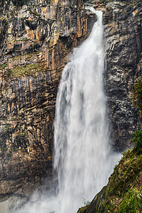
Image 1 of 11;
Click arrow to scroll or click image to enlarge
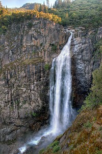
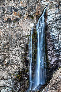
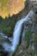
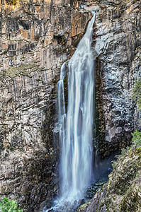
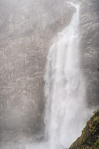
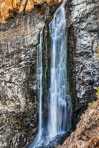
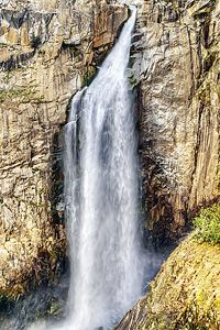
Location: Oroville, Feather Falls Scenic Area, Plumas National Forest, Butte County
Stream: Fall River
Alternate Names:

Height: 410 ft.
Access:   hike   dog   bike  
Distance: 7.9 miles (loop)
Elevation: 2500 ft. (-1000 ft., +1000 ft.)
Season: year-round
Form:   plunge
Lat/Long:39.64310, -121.27433
Directions:From Oroville, take Hwy #162 east (Olive Hwy) for 6.7 miles, turn right on Forbestown Road for 6.3 miles, turn left on Lumpkin Road for 11.4 miles to the signed turnoff for Feather Falls. Turn left at sign and drive 1.5 miles to the trailhead.

Feather Falls is one of my favourite hikes. I have been here many times now, in the spring when the falls is raging and at low flow in the fall. It is a spectacular waterfall, plunging 410 ft. along the Fall River. Feather Falls flows year-round, but is most impressive in April, when the snow is melting. Outside of Yosemite, this is one of the best waterfalls in California.

The Feather Falls hike is a very popular one, so I recommend coming here in the early morning. When I was here on a Saturday in early May, I arrived at the falls for sunrise, so I had the waterfall all to myself. But on the hike back, I must have passed about 70 other hikers on the way to see the falls. It was crazy. Feather Falls is a loop hike, the upper loop is 4.5 miles and the lower one 3.5 miles. All the guidebooks recommend hiking the lower loop into the falls and the upper loop on the return. The reason is that the shorter loop is much stepper on the return. The upper loop is much gentler so even though it is uphill on the return it is easier than the lower loop.

There is a path that leads to the top of Feather Falls, where you can look down from the brink as it plunges down into the canyon. It is definitely a sight worth seeing. But be careful around this area. The rocks can be very slippery, and people have died here before. It is not a place to take children! There are also swimming holes at the top of the falls, for later in the summer.

I wanted to get back to Feather Falls was to determine its true height. I had read on Bryan Swan and Dean Goss' world waterfalls website that they had determined that Feather Falls was not 640 ft. high, as is widely reported. Indeed, after examining the topo maps, it seemed to be more in the neighborhood of 400 ft. high. I wanted to measure it more officially with my laser rangefinder and clinometer to confirm this difference of opinion. I found that indeed Feather Falls is only 410 ft. high. It is definitely *not* 640 ft. high, and certainly nowhere near being the 6th highest waterfall in the U.S. (which is also widely reported). This came as a complete shock and big disappointment to me. I had always just assumed the 640 figure was accurate. Who came up with that figure and how? But the truth is now revealed: Feather Falls true height is 410 ft.

Update 1/1/2025: Since 2020 Feather Falls was closed due to the Bear Fire. The forest order closure expired on 12/31/24 and no new forest order was posted. By default this means the trail is now (finally) open again (though the website inexplicably does not state the trail is open). Everything is 100% rebuilt and has been for a long time. This trail should have been re-opened LONG before 2025.

It should be stressed that after the Bear Fire the trail is now 100% exposed to the elements (the trail used to be mostly through the forest - there is no forest any longer). It will be very hot in the summer and I don't recommend it. Hiking for 8 miles entirely in the heat when it is over 90 degrees will be dangerous, especially for kids and dogs. Do not come here when it is hot. Also it is worth noting that you can now pretty much see the entire loop trail as you hike along, so you can see all the people that are behind you or ahead of you on the trail.

14 Miles ESE Concow CA (Elev. 2224 ft)

This Afternoon
Showers likely, mainly after 5pm. Mostly cloudy, with a high near 48. South southwest wind around 8 mph, with gusts as high as 18 mph. Chance of precipitation is 60%. New precipitation amounts of less than a tenth of an inch possible.
Tonight
A 40 percent chance of showers, mainly before 10pm. Mostly cloudy, with a low around 38. South southwest wind around 6 mph becoming calm in the evening. New precipitation amounts between a tenth and quarter of an inch possible.
Saturday
Sunny, with a high near 53. Calm wind becoming west southwest around 5 mph in the afternoon.
Saturday Night
A 20 percent chance of showers after 11pm. Mostly cloudy, with a low around 43. Light and variable wind. New precipitation amounts of less than a tenth of an inch possible.
Sunday
Showers. High near 49. Calm wind becoming south 5 to 9 mph in the morning. Winds could gust as high as 23 mph. Chance of precipitation is 90%.
Sunday Night
Showers, with thunderstorms also possible after 11pm. Low around 42. Chance of precipitation is 90%.
Monday
Showers. High near 47. Chance of precipitation is 100%.
Monday Night
Showers likely, mainly before 11pm. Mostly cloudy, with a low around 37.
Tuesday
Showers likely, mainly after 11am. Mostly cloudy, with a high near 46.
Tuesday Night
Showers likely. Mostly cloudy, with a low around 39.
Wednesday
A chance of showers. Partly sunny, with a high near 47.
Wednesday Night
Showers likely. Mostly cloudy, with a low around 41.
Thursday
Showers likely. Mostly cloudy, with a high near 47.

Get Google Maps directions to trailhead

Zoom out on map to see all nearby waterfalls:

Other waterfalls nearby:

Frey Creek Falls 1.27 miles
Upper Frey Creek Falls 1.95 miles
Curtain Falls 2.10 miles
Lower Seven Falls 4.39 miles
Seven Falls 4.52 miles
Cascade Creek Falls 5.26 miles
French Creek Falls 6.53 miles
Upper French Creek Falls 6.61 miles
Little North Fork Falls 6.62 miles

Shasta Cascade Waterfalls Home Page

Feather Falls
5.0 out of 1 reviews