|
|
Easy |

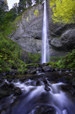
Image 1 of 1; Click arrow to scroll or click image to enlarge |
Location: Columbia River Gorge National Scenic Area, Bridal Veil, Guy W. Talbot State Park, Multnomah County Stream: Latourell Creek Alternate Names: Height: 249 ft. Access:   Distance: n/a Elevation: 150 ft. Season: year-round Form:  Lat/Long:45.53691, -122.21847 Directions:Going east along I-84, take exit 28 at Bridal Veil (28 miles east of Portland). Drive 3.2 miles west along the Columbia Gorge Scenic Hwy to the Guy W. Talbot State Park. |

2 Miles WSW Bridal Veil OR (Elev. 200 ft)
OvernightShowers. Low around 40. South southeast wind around 7 mph. Chance of precipitation is 80%.
Monday
Showers. High near 51. Breezy, with a southwest wind 9 to 17 mph, with gusts as high as 30 mph. Chance of precipitation is 90%. New precipitation amounts between a tenth and quarter of an inch possible.
Monday Night
A 50 percent chance of showers, mainly before 9pm. Partly cloudy, with a low around 36. South southwest wind 5 to 8 mph becoming east northeast after midnight.
Tuesday
A 50 percent chance of showers, mainly after 11am. Partly sunny, with a high near 52. Northeast wind 5 to 13 mph becoming west in the morning. Winds could gust as high as 20 mph.
Tuesday Night
Showers likely. Mostly cloudy, with a low around 40. West wind 9 to 14 mph, with gusts as high as 21 mph. Chance of precipitation is 70%. New precipitation amounts of less than a tenth of an inch possible.
Wednesday
Showers. High near 50. Chance of precipitation is 80%.
Wednesday Night
Showers likely, mainly before 11pm. Mostly cloudy, with a low around 39. Chance of precipitation is 60%.
Thursday
A chance of showers. Snow level 2200 feet rising to 3000 feet in the afternoon. Mostly cloudy, then gradually becoming sunny, with a high near 55.
Thursday Night
Mostly clear, with a low around 38.
Friday
Sunny, with a high near 62.
Friday Night
Mostly clear, with a low around 42.
Saturday
Sunny, with a high near 67. Breezy.
Saturday Night
Mostly clear, with a low around 46. Breezy.
| Upper Latourell Falls | 0.47 miles | |
| Shepperds Dell Falls | 1.44 miles | |
| Bridal Veil Falls | 2.38 miles | |
| Upper Bridal Veil Falls | 2.53 miles | |
| Coopey Falls | 3.35 miles | |
| Upper Coopey Falls | 3.40 miles | |
| Wahkeena Falls | 5.48 miles | |
| Fairy Falls | 5.50 miles | |
| Multnomah Falls | 6.08 miles | |
| Ecola Falls | 6.37 miles | |
| Dutchman Falls | 6.40 miles | |
| Weisendanger Falls | 6.43 miles | |
| Triple Falls | 8.28 miles | |
| Oneonta Falls | 8.36 miles | |
| Middle Oneonta Falls | 8.43 miles | |
| Lower Oneonta Falls | 8.46 miles | |
| Ponytail Falls | 8.75 miles | |
| Horsetail Falls | 8.75 miles |
| Columbia River Gorge | Waterfalls Home Page |