|
|
Easy |

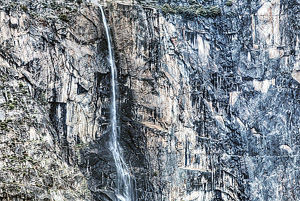
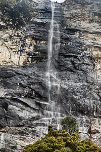
Image 1 of 2; Click arrow to scroll or click image to enlarge |
Location: Hetch Hetchy Reservoir, Yosemite National Park, Tuolumne County Stream: Falls Creek Alternate Names: Height: ~800 ft. Access:   Distance: 4.6 miles (RT) Elevation: 3800 ft. (+300 ft.) Season: Apr-Jun Form:  Lat/Long:37.96384, -119.77264 Directions:Drive to Hetch Hetchy Reservoir, one mile west of Big Oak Flat park entrance. The reservoir is 16 miles along Hetch Hetchy Rd. |


18 Miles NNW Yosemite Valley CA (Elev. 5981 ft)
TodayRain and snow showers, becoming all snow after 11am. The snow could be heavy at times. Some thunder is also possible. High near 40. Wind chill values as low as 20. Breezy, with a west southwest wind 15 to 20 mph, with gusts as high as 35 mph. Chance of precipitation is 100%. Total daytime snow accumulation of 3 to 5 inches possible.
Tonight
Snow showers before 8pm, then snow, mainly after 8pm. The snow could be heavy at times. Some thunder is also possible. Low around 24. Breezy, with a west southwest wind 15 to 20 mph decreasing to 5 to 10 mph after midnight. Winds could gust as high as 30 mph. Chance of precipitation is 100%. New snow accumulation of 4 to 8 inches possible.
Tuesday
Snow. The snow could be heavy at times. High near 34. Wind chill values as low as 16. Southwest wind 5 to 10 mph, with gusts as high as 20 mph. Chance of precipitation is 90%. New snow accumulation of 10 to 14 inches possible.
Tuesday Night
Snow showers before 11pm, then a slight chance of snow after 11pm. The snow could be heavy at times. Some thunder is also possible. Low around 22. West southwest wind 5 to 10 mph becoming light in the evening. Winds could gust as high as 15 mph. Chance of precipitation is 80%. New snow accumulation of 3 to 5 inches possible.
Wednesday
A 20 percent chance of snow after 11am. Mostly sunny, with a high near 39. North wind around 5 mph becoming west in the morning.
Wednesday Night
A 20 percent chance of snow before 11pm. Partly cloudy, with a low around 23. West wind around 5 mph becoming east northeast after midnight.
Thursday
A 20 percent chance of snow after 11am. Mostly sunny, with a high near 43. East northeast wind around 5 mph becoming west southwest in the afternoon.
Thursday Night
A 20 percent chance of snow before 11pm. Partly cloudy, with a low around 27. West wind 5 to 10 mph becoming east northeast after midnight.
Friday
Sunny, with a high near 50. East northeast wind 5 to 10 mph becoming west in the afternoon.
Friday Night
Mostly clear, with a low around 31. West northwest wind 5 to 10 mph becoming east northeast in the evening.
Saturday
Sunny, with a high near 52. East northeast wind 5 to 10 mph.
Saturday Night
Mostly clear, with a low around 34. East northeast wind 5 to 15 mph.
Sunday
Sunny, with a high near 57. East wind 5 to 15 mph.
| High Sierra | Waterfalls Home Page |