As of Jan. 1 the snow pack in California is at 135% (northern CA), 183% (central Sierra) and 206% (southern Sierra). Precipitation is at 116% (north), 162% (central), and 149% (south). This is after the big storm we just had. More storms are coming this week, so we are in very good shape. We need to pray it continues, however. There are still 3 months of winter left and I am still afraid the tap is going to completely shut off as it did last year. “Ask the Lord for rain in the springtime; it is the Lord who sends the thunderstorms. He gives showers of rain to all people and plants of the field to everyone.” (Zech 10:1)
This one was taken before the storm on Boxing Day. Who knows what that is? ha ha.
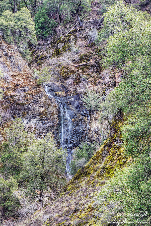
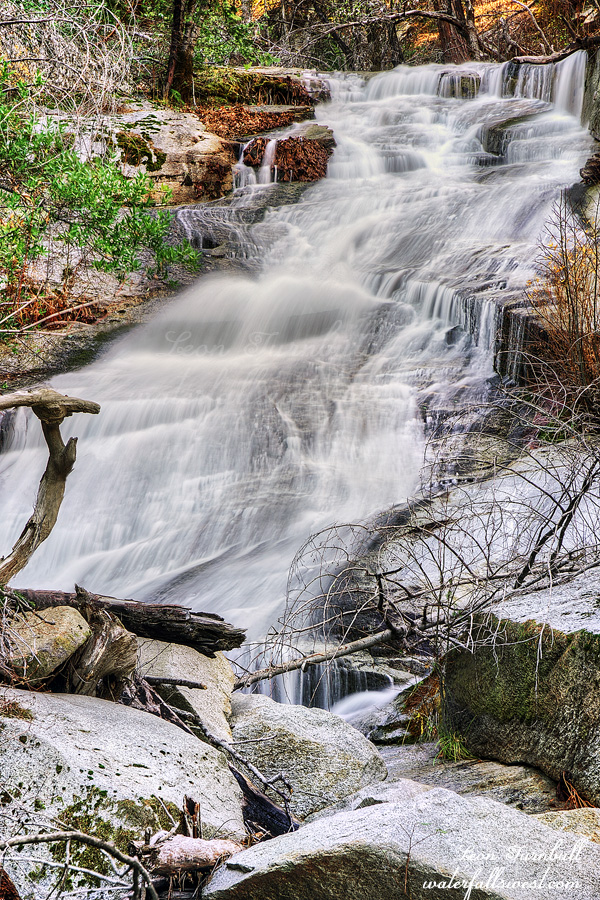
I have wanted to try this one for awhile. Access is questionable. However, I finally found a route to it that is legal so on the day after Christmas I gave it a shot. It did not quite work out the way I wanted.
The first part of the hike is along a logging road on public land. It was a lovely and very easy going section. My back was hurting from the day before though I have no idea why. All I did on Christmas Day was sit around the house eating, drinking, and opening presents. Or rather, watch people open presents – my big present was the new Gopro camera which I got early. Anyway, going on a tough hike was probably not very smart. And it was about to get very tough.
I made it down to Montgomery Creek which I would have to cross. The creek was flowing fairly strong. The crossing was easy but it was deep. Up to my thighs. There was a path going up the other side which I was not expecting. Obviously others have had this idea before. When I got to Lick Creek I saw the creek was at very low flow, much lower than I expected. My initial idea was to wade straight up the creek to the waterfall so I wanted low flow in the creek but definitely not this low. I was a bit bummed. With Montgomery Creek flowing well I would have thought this creek would be much better than it was. The wading up the creek started well and easy enough. That did not last long. It soon became too brushy to continue. I decided to climb up the bank, hoping for a higher path. That was a big mistake. The poison oak was Unbearable. Atrocious. Savage. Wicked. Vicious. You get the picture? Nonetheless, and stupidly, I continued on a bit and soon came to a long distance viewpoint of the waterfall. It was a clear shot so I took a photo and called it a day. If it wasn’t for the poison oak I would have tried to get closer, but I had more than enough of it already. I was out of there. Lickety split. Lick Creek Falls is 69 ft. high. It would certainly be a fantastic view at high flows. I returned to Montgomery Creek and explored further up the creek, hoping to perhaps find another small waterfall, but all I found was more poison oak. I ate my lunch back at the crossing and then climbed out of the canyon and back to the car. It was a croaky oaky day in Shasta National Forest.
Posted in Northern CA, Waterfalls by leapin26: January 4, 2023
I knew there was an upper falls on Swamp Creek and this seemed like a great day to try it. It was supposed to be cloudy all morning at least, if not all day. One forecast said the clouds would break in the afternoon. Of course by 10AM I could see the clouds breaking and the sun came out. I was not even close to the waterfall. But I did not doubt this time. God would provide the cloud cover for me (and He did! thank you Lord!)
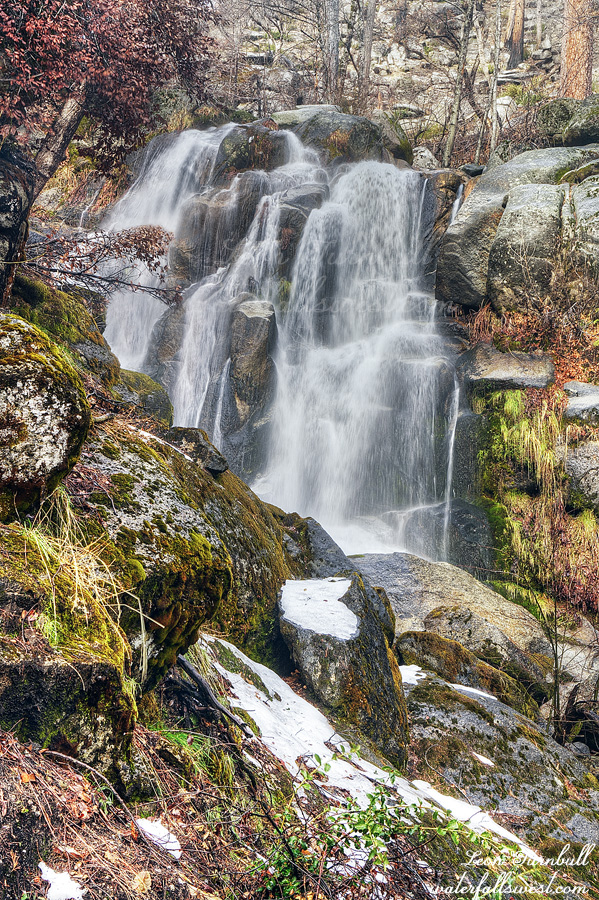
The first problem with this hike is that it is a 2000 ft. climb UP THE MOUNTAIN! There is NO TRAIL. I was not really sure how excited I was to do this hike. On the one hand I wanted to do it. On the other hand I was intimidated by the elevation gain. Let’s climb a 2000 ft. mountain with no trail whatsoever. Or let’s go back to bed. What would you choose? Also, as I mentioned I injured my foot the previous day. How would that hold up on a very very strenuous hike? Actually, the foot did very well once I got off the rocky railroad tracks and started climbing. Good news. Also good news, it was not cliffy, it was not brushy, and there was no poison oak. Bad news, it was a 2000 ft. climb straight up. But other than that, it was easy! Ha ha. I was hiking up through the Camp Fire devastation of 2018, which is probably the reason it was not brushy and there was no oak. Interestingly, I saw a huge water hose that was left by the firefighters. It was probably almost a mile long. I hit the snow line at about 3900 ft. elevation and from that point it was a bit hard to hike because the snow was soft and about a foot deep. The snow might make it too dangerous to get down to the waterfall. But that was the least of my worries.
I thought it would be quite easy to get down to the creek at the waterfall. Nope! In fact, it was horribly cliffy and sketchy. I used my rope to descend the last 100 ft. or so to the waterfall viewpoint. I should not have done this. It was quite stupid. However, when you have climbed up 2000 ft. to see a waterfall, you really really really do not want to be shut out. It would have been extremely disappointing. So … I got out my rope (I used all three ropes that I brought) and descended down the cliff side very very carefully, very very slowly, one step at a time. I came down to a spot where I could finally see the waterfall and set up my tripod on top of a sketchy rock beside a sketchy burned tree on top of a huge dropoff. The mist from the falls additionally made it even more difficult to take a photo. But I made it!
Upper Swamp Creek Falls is a gorgeous 46 foot drop. I just wish it was easier to get to! I climbed back up to the top, had my lunch, and then descended the 2000 ft. back down to the railroad tracks. It was much easier going down, believe me! It was another wild and crazy day in Plumas National Forest.
Posted in Northern CA, Waterfalls by leapin26: December 28, 2022
The return to the Swamp. Last time I was here I had the kids with me. This time, no kids. Nekoda is out of town and Jadon of course did not want to come (I tried). The hike is easy but is along the active railroad tracks. The first part crosses a railroad bridge in a scene straight out of Stand By Me. This one always freaks me out. A friend of mine mentioned to me once he had a real Stand By Me experience on this bridge and barely made it off in time. Yikes! I did not see any trains on my hike in to the falls but I saw one on the hike back out. I was almost back to the bridge. He was coming along very slowly. So slowly I thought he was going to stop completely. Then when he got about halfway past me (it was a very long train) he sped up and started going quite fast. I think he was just going slowly until all the cars got over the bridge. It took eight minutes for the train to pass me by (I only know that because I was taking video of it – ha ha).
It is not easy walking along the railroad tracks. It is very rocky. I hurt my foot on the treadmill (somehow) the previous day so that made hiking on the rocks much more painful. I trudged on to the waterfall. I got to the viewpoint and took photos. I did not go to the bottom this time.
In case you are wondering I did not just go out on this easy hike to this waterfall which I have been to before. I was going elsewhere. Part 2 is coming …
Posted in Northern CA, Waterfalls by leapin26: December 24, 2022
We are now in the Dog Days of winter, waiting for the next storm to arrive. Will we have another dry Jan/Feb/Mar as we had last year? Or will the storms pick up again at the end of Dec? We only need about 1 big storm per month to end up at average for the year. Pray pray pray.
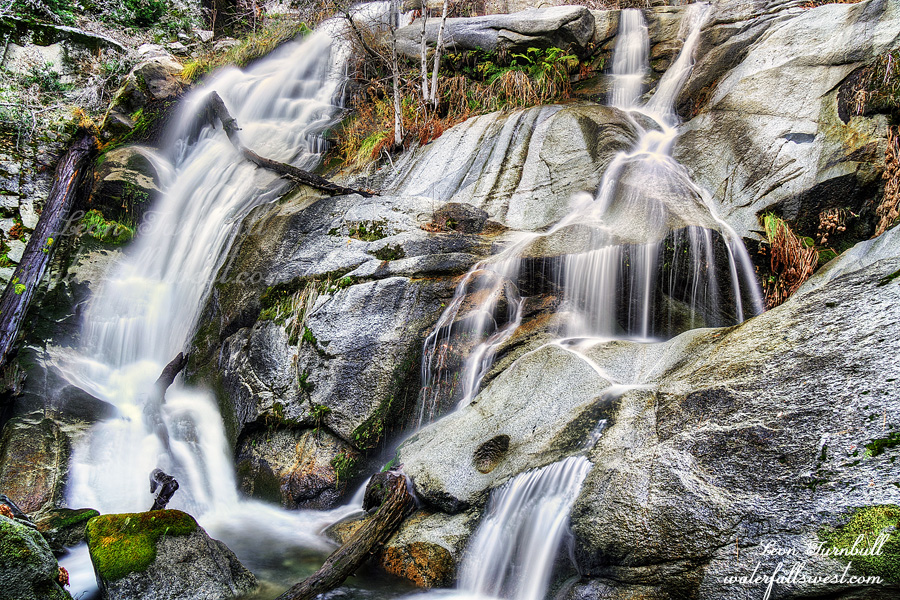
From the lower Dogwood Creek Falls, I found a trail going up to the upper Falls. It was definitely a human trail but also incredibly overgrown. At one point I had to take my backpack off to squeeze under a log. But I made it. It was a little easier getting down to the upper waterfall with no cliffs and I did not need to use my rope. It is another nice one, 54 feet high. One foot higher than the lower falls.
I retreated down the mountain, trying to follow the trail back to the road. But it became impossibly brushy. I gave up. I decided to exit the trail and head straight down to the road. It was a bit easier that way. After driving down the horribly narrow road back to the highway, a stop at Jakes in Oroville was definitely on the agenda. It was another great day in Plumas National Forest.
Posted in Northern CA, Waterfalls by leapin26: December 21, 2022
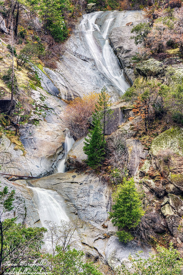
My friend Jeremy told me about some waterfalls on Dogwood Creek quite a while ago but I did not make it up there to check them out until this weekend. The big deterrent for me was the horrible road. It is another one of those very steep and very narrow and rough roads with absolutely no turn outs. This one is even worse than the previous one I did recently. I prayed profusely again that I would not see another car as I drove up it and then back down later. Once again God obliged. Thank you Lord. Whew. Driving these roads is so stressful.
I arrived at the creek at noon and ate my lunch before starting the hike. There is a path going up along the creek so it is really not that hard. Until you reach the waterfall, that is. Then it becomes cliffy. Horribly cliffy. Impossibly cliffy. How was I going to get down to the creek and waterfall? I saw a possible route down but it would require rope. Thankfully, I brought my rope. There is no way I could’ve done it otherwise. I made it down safely and up to the waterfall. What a beauty! 53 feet high. A hidden gem. And much more difficult than I anticipated.
When I reviewed my friend’s photos afterwards, it seems he did not make it to this one. Maybe because it was so cliffy? But also it seems he went to some other falls that I did not see. I think I will be exploring this creek again on another day. Except for that darn road.
I did continue on to the upper Falls. Stay tuned for part two…
Posted in Northern CA, Waterfalls by leapin26: December 19, 2022
