
LICKETY SPLIT
As of Jan. 1 the snow pack in California is at 135% (northern CA), 183% (central Sierra) and 206% (southern Sierra). Precipitation is at 116% (north), 162% (central), and 149% (south). This is after the big storm we just had. More storms are coming this week, so we are in very good shape. We need to pray it continues, however. There are still 3 months of winter left and I am still afraid the tap is going to completely shut off as it did last year. “Ask the Lord for rain in the springtime; it is the Lord who sends the thunderstorms. He gives showers of rain to all people and plants of the field to everyone.” (Zech 10:1)
This one was taken before the storm on Boxing Day. Who knows what that is? ha ha.
I have wanted to try this one for awhile. Access is questionable. However, I finally found a route to it that is legal so on the day after Christmas I gave it a shot. It did not quite work out the way I wanted.
The first part of the hike is along a logging road on public land. It was a lovely and very easy going section. My back was hurting from the day before though I have no idea why. All I did on Christmas Day was sit around the house eating, drinking, and opening presents. Or rather, watch people open presents – my big present was the new Gopro camera which I got early. Anyway, going on a tough hike was probably not very smart. And it was about to get very tough.
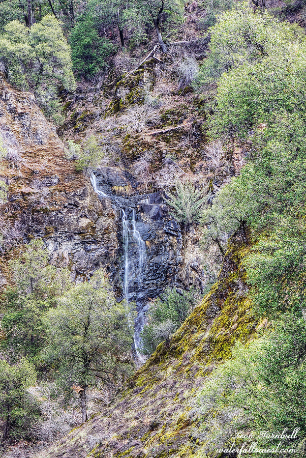
I made it down to Montgomery Creek which I would have to cross. The creek was flowing fairly strong. The crossing was easy but it was deep. Up to my thighs. There was a path going up the other side which I was not expecting. Obviously others have had this idea before. When I got to Lick Creek I saw the creek was at very low flow, much lower than I expected. My initial idea was to wade straight up the creek to the waterfall so I wanted low flow in the creek but definitely not this low. I was a bit bummed. With Montgomery Creek flowing well I would have thought this creek would be much better than it was. The wading up the creek started well and easy enough. That did not last long. It soon became too brushy to continue. I decided to climb up the bank, hoping for a higher path. That was a big mistake. The poison oak was Unbearable. Atrocious. Savage. Wicked. Vicious. You get the picture? Nonetheless, and stupidly, I continued on a bit and soon came to a long distance viewpoint of the waterfall. It was a clear shot so I took a photo and called it a day. If it wasn’t for the poison oak I would have tried to get closer, but I had more than enough of it already. I was out of there. Lickety split. Lick Creek Falls is 69 ft. high. It would certainly be a fantastic view at high flows. I returned to Montgomery Creek and explored further up the creek, hoping to perhaps find another small waterfall, but all I found was more poison oak. I ate my lunch back at the crossing and then climbed out of the canyon and back to the car. It was a croaky oaky day in Shasta National Forest.
No Comments