Palisade 2

Here’s another view of Palisade Falls. I’m looking forward to the long weekend, and going on another hike or two, though it won’t be anything as awesome as Palisade Falls. But it is always nice to get out and enjoy the great outdoors and beauty of God’s creation.

No Comments

The River

I went back to Soda Springs Rd this weekend, this time starting from Foresthill. The road is much better from that direction, and not nearly as bone-jarring. My plan was to hike the trail from Soda Springs Rd down to Palisade Falls, a trail which I had found last week. It was going to be a doozie of a hike.

I left super early from home as usual, as I wanted to start hiking before sunrise. I had no idea how long it would take me to get down to the river, but I knew I had to be down there before 8AM, when the sun would start to hit the waterfall. I estimated it would be about a 2 mile hike and a 2000 ft. elevation loss. That is steep!

As I drove up the road in the dark, I saw my first bear of the year! This made me very excited. It seems that I do not see much in the way of bears and wildlife compared to other people, even though I am out in the wilderness almost every weekend, and usually at hours when wildlife is active too. I don’t know what it is. I have never ever seen a bear in any national park, which is very odd. I saw two bears last year (2011) in Auburn in the spring, but I have not seen any since then. So I was definitely excited to see one today. It was dark, so no pictures were possible. He was along the road, and when he saw me driving up he started lumbering away from me up the road. He kept looking back to see if the firebeast was still coming, and when he saw that it was he would turn and start lumbering away again. Finally he got off the road into the bushes. It was actually very near to where I saw one a few years ago when I hiked to Wabena Falls, and rather near the trailhead where I would be hiking today. (p.s. does anyone out there besides myself and my son Jadon know what a firebeast is?).

I arrived at the trailhead and it was just getting light. I was able to see the entire way down the canyon all the way to the river. You could even hear the river, though it was not flowing strong. I kinda started wondering what I was getting into. It was a long long way down, and steep. Did I mention it looked steep? It seemed like the hike would be on par with the Wabena Falls hike, the craziest hike I have ever done, and that would mean I would be late getting back home, and I needed to be home by 1PM or else. Well, I decided to go for it anyway, and I am sure glad I did.

The trail was not nearly as bad as I anticipated. It was actually a fantastic, well graded trail. Yes you lose 2100 ft. in elevation in about 3 or so miles, but it did not have many steep spots, it just had a steady grade and got the job done. The hike back up was indeed a doozie, and I was worn out by the end of it, but compared to Wabena Falls, it was a cake walk. There was only one really tough spot, and it came near the end where the trail crossed a ravine. There was a steep dropoff where you had to go down, then clamber back up to the trail on the other side. Fortunately there were ropes there to ease the process, but even with ropes it was a bit on the scary side. I made it across the ravine, and continued down to the river.

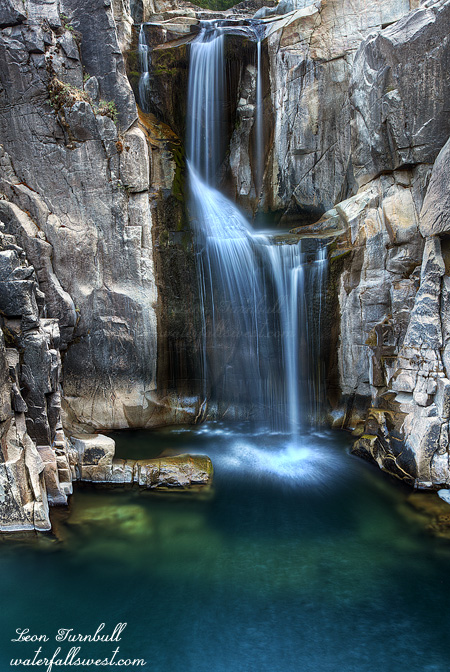
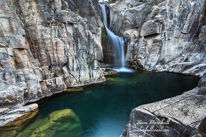
It took about an hour and 15 minutes to get down, and I arrived at Palisade Falls at about 7:15AM. Perfect timing. I was happy. I noticed some campers down at the bottom of the falls, but it seemed like they were still sleeping. I saw no one moving about, even when I left about an hour later. I think that is a great thing about camping, you can sleep in to your heart’s desire (unless you are a photographer of course). The North Fork American River was flowing at about 50 cubic feet per second (cfs) when I checked it the previous day. It is not a lot of flow, and the waterfall was not roaring by any means, but it was quite nice. Pretty is sometimes nicer than roaring, and 47 ft. high Palisade Falls was certainly pretty. Another nice thing about the low flow is that you can get right down to the river side, for a great perspective from below. This would not have been possible earlier in the summer, and although I did have to get my feet slightly wet, it was certainly worth it to get a shot from down beside the river.

Well it was after 8AM now, and the sun was starting to strike the waterfall just as I had calculated (Photographer’s Ephemeris is such a great tool for doing this). I packed up my things and started the long slow slog back up the mountain. It took me 2 hours and 15 minutes to get back up. I took it slow and steady, drank lots of water, and had quite a few rests, but my legs were dead tired at the end. I am sure glad this was not a Wabena Falls caliber of hike, as I don’t know that I would have made it today if that was the case, but I will definitely be returning on this hike and trail again in the future. It was a great morning on my all time favorite river.

9 Comments

Rainbows

This photo was taken a bit after sunrise. There was not any great sunrise color on this day, but the rainbow over the canyon really made this shot I think (a double rainbow, even better). What you are looking at is the North Fork American River canyon. The mountain is majestic Snow Mountain rising 8074 ft. above sea level (on the right, poking up in the distance is Devils Peak). In the spring, the second highest waterfall in California (2200 ft. high) tumbles vigorously down the slope of Snow Mountain, and if you look closely you can see the path it takes in this image. Of course in late August, it is all dried up, but I think this spot would be a fantastic viewpoint of the waterfall in the spring, especially at sunrise or sunset (that is, if you could get to this spot in the spring, which is not likely, but that is a different story).

The story for this day was not to shoot sunrise from this location, but instead to find a new and quick way down to Heath Falls on the North Fork American River. It was going to be epic! But alas, it was not to be. It was not the cliffs that did me in here, it was the manzanita brush. On Google Earth, the brush did not look bad at all, and even from the cliffs here looking down, the brush did not look bad, but once I started going down, it eventually just became too thick and un-manageable. I was forced to turn back. I was bummed!

For a brief minute or two, I thought I was going to make it. There was actually an old trail here leading down to the bottom, something totally unexpected. It must have been an old miner’s trail, and from the look of it, it had not been traversed since the mining days. Nonetheless it was there and it started out very good, however once it hit the thick brush, it disappeared very quickly. With all the fires and lightning strikes happening in the Sierra this week, I kept thinking how nice it would be if one happened here to clear out all this brush, but it seems that is not going to happen this year either. I tried many different routes to try to get through the brush, and I just could not do it. In the end, I thought maybe from the other side of the ravine might be a possibility, which is down to the left of this view, and I want to return here again to give it another go, but that will not happen this year.

Some of you may know the “normal” way to get to Heath Falls is a long, difficult hike about 6.5 miles one way, impossible to get there in good lighting conditions on a day hike, and it also involves a sketchy crossing of private property to reach it. I was hoping to find a better and quicker route, and that involved driving from Soda Springs down through the Cedars and across the North Fork American River. The road from Soda Springs down to the river is absolutely awful. Indeed I would say it is almost as bad as the Bowman Lake road. If you are familiar with that road you know this one must be quite bad if I make this comparison. It is just extremely rocky and bumpy. Your jaw will be rattling for days afterward. For about 2 miles on each side of the river, and stretching apparently all the way down to Heath Falls, a group called the Cedars owns the land, and they do not want anyone else sniffing on the land either. You would think they would keep their road in better condition at least.

After trying Heath Falls, I was still in an exploring mood so I went further up Soda Springs Road in search of a trail down to Palisade Falls. I knew there was a trail down to it on this side of the river, but I did not know where it was, so I took a wild guess on my map. It was not exactly where I thought it might be, but I eventually did find it. I did not go down because I had already spent too much time trying to get down to Heath Falls and it was too late in the morning, but this is one I would really like to return to, perhaps even this year (though I am not anxious to brave driving this road again anytime soon). I think also that it will be of epic steepness comparable to the Wabena Falls trail. Sounds like fun. Maybe.

No Comments

Scrubbing

Just a Western Scrub Jay, but was able to get super close to it to take a shot. This is from our Joshua Tree trip in the spring.

It is still far too hot to hike here. We have now had 10 straight 100+ degree days, and still counting. Maybe this weekend I can hike again?

No Comments

Digging

I realized that I had not shared very many of my wildlife photos with you from earlier this year, when we went down to Disneyland, Joshua Tree NP, and the Salton Sea. This little burrowing owl we found at the visitor center at the Sony Bono Salton Sea Wildlife Refuge. The lady at the visitor center showed us where it was. Would she have been so willing to do this if we did not have two cute kids with us? I think not. She told us not to cross the ditch to get too close to the owl (which obviously makes sense), so I sat back on the side of the road with my big lens and fired away. The owl was content to sit there and watch all the commotion passing by from his little man-made house.

No Comments