Well last Thursday when I realized that the Pineapple Express was powering its juice in to northern California, and we were going to be getting 7 inches of rain, I knew that the waterfalls would be roaring. Monday looked like it was going to be the best waterfall day, so I promptly asked my boss for Monday off. I was set to rock and roll. Now we just needed the rain. And it came.
We actually received 12 inches of rain in the foothills. Folsom Lake rose from 17 percent to about 27 percent capacity, and we are still getting runoff from this storm and will be throughout the week. And don’t forget the five feet of snow that fell in the mountains, which will be coming down eventually. Of course we still need much more rain but it is not quite the bleak sham that the media has been reporting the last couple days.
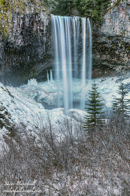
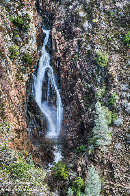
On Sunday the North Fork American River was up to 10,000 cubic feet per second, and that means ALL the waterfalls would be flowing awesomely. On Monday morning I was off to see one of my favorites, 134 ft. high Canyon Creek Falls. The river flow was down to about 6000 cfs, which was about the same flow as when I visited it in Dec 2012. One of these days I want to see this waterfall at monster flow, but I’m still waiting for that chance.
When I left the house, it was raining and foggy. You may remember when I visited this waterfall last time, I experienced a small miracle. It was raining, foggy, and windy and as I hiked down to the waterfall that day, I did not even think I would get to see it because of the fog, or photograph it at all. So I prayed to God to stop the rain, fog, and wind, and as soon as I got to the waterfall viewpoint, all three were gone: no rain, no fog, no wind. It was certainly a miracle and blessing from God. Well it looked like the same thing might happen again this year. However, this year I DID NOT ask God to stop the rain. We need every ounce of rain we can get this year, and I really would not mind if it was raining when I got there. I did ask Him to take the fog away though, because it would really suck to hike all the way down there and not be able to see anything at all!
I arrived at the trailhead and found another car parked in my spot. It had Minnesota plates, which was strange. What person from Minnesota would be out here hiking to this waterfall so darn early in the morning! There is only one parking spot at the trailhead, so I had to drive a bit further back up the road. As I came back down to that car, I was video-taping with my Go Pro camera. When I got to the car, I stopped and was making commentary for my video, saying things like, you know, why are they parked in my spot, who would be crazy enough to be out here so early in the morning, that kind of thing. Ok well after doing that, I continued on down the trail. After only a short distance, I realized I forgot my umbrella back at the car, so… I decided to go back to get it because it was “supposed” to rain some more that morning. I got back to the car, and lo and behold, there was a man getting out of the car, and getting ready to hike. He was sleeping in the car! And I must have woken him with my crazy commentary! Oh my gosh. I apologized to him for waking him. He was very cool about it though, saying that he needed to get up anyway. He was an old miner dude who had a claim down by the river, and he was going down there to pan for some gold. Geez, talk about embarrassing. I had no idea anyone was sleeping in the car!
Well anyway, la la la, off I went down to the waterfall again. Well this year as I hiked down to the waterfall viewpoint, there was no rain. There was no wind. There was also no fog. I guess all of that is good stuff, except that the sun had come out! It was not supposed to be out until around noon, certainly not this early in the morning! If I had thought the sun would be out, I would have started my hike much sooner than I did, and it looked like the sun was shining right down in the canyon, right on the waterfall. So I prayed again, this time: please God, don’t let the sun be shining on the waterfall. Well I got to the waterfall viewpoint, the falls was thundering down the canyon, much the same as last time. It is an incredible waterfall, and the view is spectacular, with the thundering waterfall on one side, and the raging river on the other side. The sun was not exactly quite shining on the waterfall, but it was almost on it. However, the viewpoint was all in sun, and that made photographing the falls from there very difficult. I continued further down the trail looking for a different viewpoint that was not in the sun. All I found was poison oak. And a lot of it. You can continue quite a ways, perhaps getting all the way down to the bottom, but it seemed far too brushy to try it. I came back to the main viewpoint and stopped again before I headed back up the hill. Enter stage right: thick clouds covering up the sun. Sweet goodness! The clouds made the lighting much more pleasant, and I was actually able to take some decent photos of the waterfall. Once again, God answered my prayer here. He is surely awesome. And so is this waterfall.