
LiNoFoMiFoFeR
Still no rain in California. But I still have faith. It is coming.
Some people think there is no water anywhere in California, but that is just not true. You do need to be looking in the right places, however. Hence my hike this weekend to the Little North Fork of the Middle Fork Feather River. Or LNFMFFR for short. Or LiNoFoMiFoFeR if you want to get a little silly. I like silly. I knew that this river would have some water in it, though I did not know how much. I was not expecting much, but I knew the waterfalls would flowing somewhat at least.
There is supposed to be a 30 footer on this river. Somewhere. I am more confused now about where it might be, or if it might be. I found a trail on my National Forest map going down to the river, though it is not on my Topo map, nor is it listed anywhere on the National Forest website or elsewhere. I thought it might be one of those old trails that no longer exists, and as such did not have much hope of finding it, but it seemed to me if I could find this trail down to the LiNoFoMiFoFeR, and once there, work my way downstream a short distance, I would find the waterfalls. I found the trail. It was actually a well marked trail and it seemed a well traveled and easy to follow trail, and it went right down to the river exactly where I thought it would. I found much evidence of an old mining operation down at the river, including the very interesting remains of an old mining bridge over the river. The trail is called the Sky High trail. Actually I lied. It is listed on the NF website, but I did not notice it because of the name of the trail: the name does not intuitively indicate you are hiking down to the Little North Fork river.
Another bonus: the river was flowing very very well. Much stronger than I would have thought possible. Why? I am not really sure but I think it might be snow melt that is happening since it has been so warm recently. Anyway, it was a pleasant surprise.
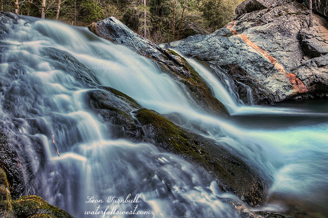
However, working my way downstream from here was totally out of the question. Steep cliffs lined both sides of the river. Going downstream was not possible. However again, there was a small waterfall right here, and this was actually one of the waterfalls I was looking for or so I thought, which I had initially figured would be much further downstream. The kayakers call this one Jaroslav’s Drop or something, but now it gets even more confusing because the kayakers say this waterfall is 30-40 ft. high. It is only 12 ft. high at tops! Although I was certain at the time that this was what was called Jaroslav’s Drop, now I am not so certain. I think there still might be a 30 footer on this creek. Somewhere. But where? If it is downstream, it will not be possible to get to it. Upstream the terrain seems too flat and unlikely for any waterfalls. It is a mystery, and more research will be required to find it. But I will be back again someday for sure. And perhaps quite soon.
No Comments