The Grand Canyon of the Tuolumne River. Yosemite National Park. I have been to the main waterfalls on a day hike but I have always wanted to explore more of it. In peak spring season. Waterwheel Falls at peak flow. That was my dream. Starting at Tuolumne Meadows is a big NO. By the time Tioga Pass road opens the waterfalls are already at much reduced flow (whether it is a good winter or a bad winter, it does not matter). There is only one way in to the Tuolumne River in early season and spoiler alert: it is very difficult. (surprise surprise)
It should be a LOT easier than it is, frankly. We will come to that shortly.
I began the big journey at Hetch Hetchy Reservoir. I arrived at the gate 30 minutes before opening and there were already 6 cars ahead of me. Dang, I wanted to be first in line (like last year) so I could start my hike as early as humanly possible. It would be a very tough and long day. Well no big deal, the ranger even opened the gate 10 minutes early. I picked up my permit. They made me sit down with the ranger to talk about my itinerary. This tells you something about how difficult and crazy my planned route was going to be. But it was a good thing because I picked up a couple tips and adjusted my planned starting point which would make my hike a bit shorter and easier. (slightly easier).
I was planning six nights but I had food for seven nights (eight days) in case I wanted or needed to stay an extra night. My pack weight was 46 pounds with 11 pounds of food! I also had to carry extra warm clothes (it would be cold at night) and rain gear (there were showers in the forecast) and spikes (there was still snow). At least my pack should be a bit lighter on the return trip out of the canyon after I ate all that food.
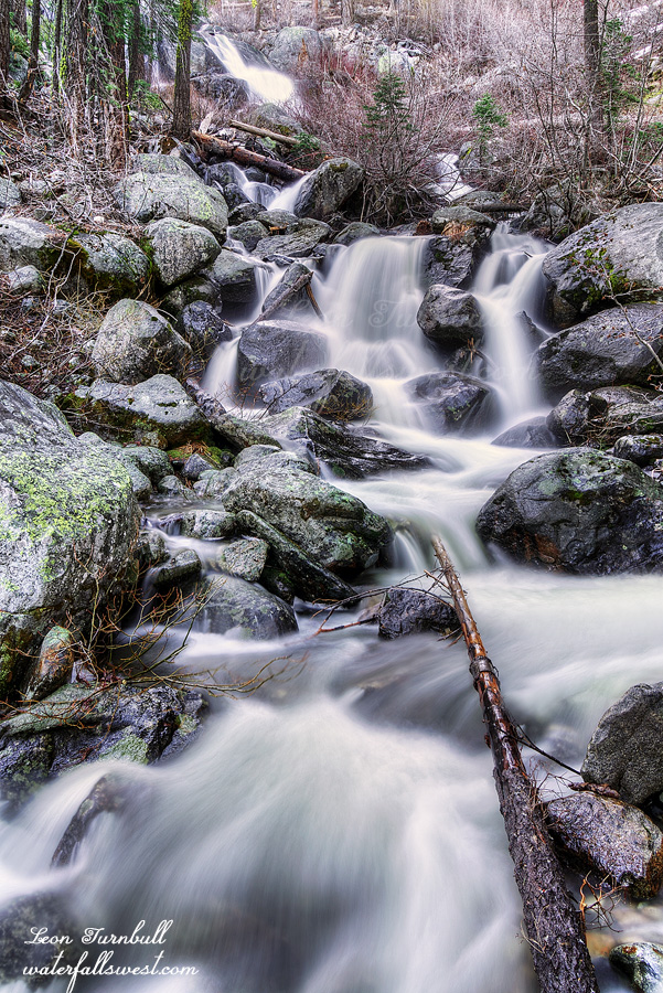
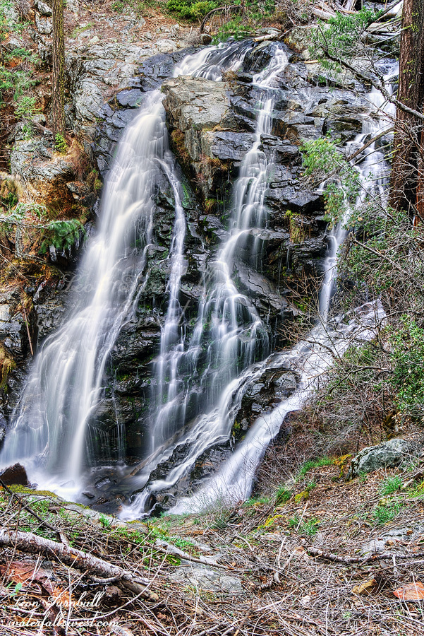
My first day would take me 11 miles to Harden Lake via Smith Meadows. A whopping 3700 ft. of elevation gain. If I could make it I had hopes to continue an additional 2 miles to Morrison Creek. Upper Morrison Creek Falls is pictured here.
It is a tough climb but the first section of trail to Smith Meadows is not too bad. There is some overgrowth and bushwhacking involved – which I did not know about beforehand – but I made it to the creek crossing in 3 hours. Not bad. My hopes were up. The ranger told me (and also I heard from others) that the section from here to Harden Lake is hopeless. The trail completely disappears. I knew it would be difficult but it started out pretty good and I was beginning to think they were all wrong. The trail was great. Then the fatal moment finally came: the trail completely disappeared in a wall of brush 10 feet high. I did not know which way to go. I seriously thought I was going to have to retreat back to the car. After quite a while of searching around I finally broke through the brush and found the trail again. I continued on. From here on until the top of the ridge it is a horrible bushwhack. The good news is that you can still follow the trail through the brush which is up to your waist or chest or higher. It took at least an hour or more of solid bushwhacking to reach the top of the ridge. Finally at the top, the last section of trail to Harden Lake is clear. How do you spell RELIEF?
Why is this trail so darn difficult? It is greatly upsetting to me. The trail should be clear. There was a fire many years ago and since then the brush has overgrown the entire area. But the park has not cleared the trail yet! This is a principal trail in Yosemite National Park and they have not bothered to do any maintenance on the trail whatsoever. They have let it go to rot. This trail is the ONLY way in to the Tuolumne River in early season. Why would they just abandon an established park trail? The ranger even told me that the trail crews were starting on the day I started my hike. Did I see any crews working on the trail when I returned some days later? Nada. I will tell you one thing: If I had $43 billion to spend like some people apparently do I would spend it on worthwhile things, and one of those things would be to clear every trail in every park and national forest in the country. This was the realization I came to as I battled my way along, unable to see the sunlight above me because the brush was so high over my head. Unfortunately I highly doubt I will ever have that kind of money to spend. Ha ha.
It took 7 hours in total to reach Harden Lake. I was done and much too tired to continue to Morrison Creek. I would spend my first night camping at Harden Lake and get up early to make it to Upper Morrison Creek Falls in the morning. Harden Lake was more like a pond then a lake. It does not have any inlet or outlet stream so it fills (I guess) entirely from snow melt. Even though we had a bad winter it is early season and I expected it to be much nicer than it was. It was also very difficult to retrieve drinkable water from the lake because it was so scummy all around the edge of the lake. Nonetheless I made do and found a nice place to setup camp and had a very lovely evening, falling asleep to the sounds of the frogs at Harden Lake. I love the sound of frogs and there were probably many hundreds of them at Harden Lake. They were amazingly loud. You gotta wonder what they talk about to each other non-stop all night long. They are such an amazing creation of God.
Posted in Waterfalls, Yosemite by leapin26: May 7, 2022
I slept fairly well in the car. The first time I’ve slept in the new Yeti. I got up at sunrise and prepared for the short hike down to the middle and lower falls of Patterson Creek (and one other one as well).
It is a little brushy but not “too difficult”. The biggest obstacle is the HUGE poison oak which is unavoidable. I was already going to get it bad so I may as well continue on the hike.
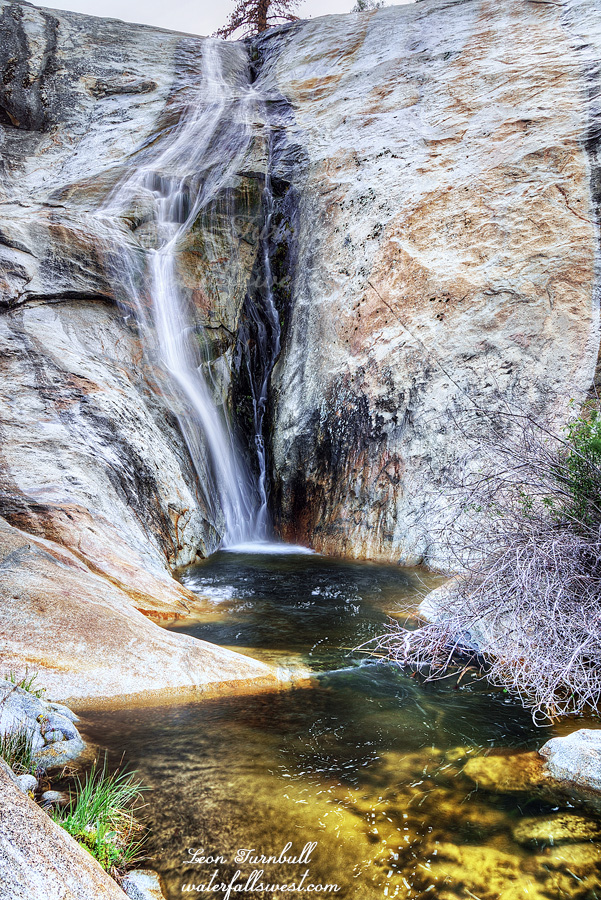
The lower falls is 306 ft. high and the middle falls is 121 ft. high. The middle falls is shown here. I liked both these waterfalls but again they would be much better at higher flows.
I returned to the car and then made the long drive home. I was so tired when I got home that I went to bed at 5:30PM and slept for 11 hours. I don’t know why I was so tired because I thought I had a decent sleep in the car but nonetheless I could not keep my eyes open past 5:30pm. That 11 hour sleep felt very good.
Posted in Southern Sierra, Waterfalls by leapin26: April 27, 2022
I was not planning to come here at all this year but a late season April storm messed up my plans. I guess I should say it just delayed my plans a bit because with 2-3 feet of new snow on the ground I would not be able to get to where I wanted to go this weekend. I decided to drive down to the Central Sierra for the weekend instead. The waterfalls here should be flowing very well, I determined, and I had not seen them before. Humph.
It is a five hour drive to Balch Camp and I arrived a bit before noon. I drove up to Patterson Creek Falls to check it out first. I would be returning in the morning to take photos but I just wanted to see it and also see if I could get down to the lower falls. I was very disappointed in the flow of the creek. It is a small drainage but with recent rain and snow melt it should be flowing a lot better than this. I was expecting a lot more. Sigh. I tried getting up closer to the waterfall but found it impossible due to very thick brush. A roadside photo is the best you can do here. Brush and poison oak were the major themes for the weekend (and perhaps, my life). The poison oak here is HUGE. In fact it was so big I did not even think it was poison oak at first. Poison oak does not get this big, does it? Ah well, tell that to my itchy body when I got back home.
I retreated back down the hill to Dinkey Creek. I wanted to backpack a short distance in to the creek and then hike up to a waterfall on Dinkey Creek. It was supposed to be a VERY EASY HIKE. There is a well defined trail on Google Earth. In fact it was supposed to be so easy and short (only a mile) I wondered if I should even do it. (I usually like hiking longer when I am backpacking).
The trail started out ok but it was already overgrown. The grasses were very long, above my knees. At least I could follow it (so far). Thankfully there were no ticks. It could have been disastrous if there were any of those buggers. Everything changed pretty quickly. The trail down to the creek was now completely overgrown with a huge amount of brush and deadfall. This is an easy hike? It was not even worth the effort to go down especially when I would have to hike this four times (I would have to come back up to continue to the waterfall). I decided to retreat and hike straight out to the waterfall and camp there. I was not very sure there would even be camping at the waterfall but maybe that trail would be better. Again, it was supposed to be a very easy and well defined trail. Again, it was completely overgrown and very difficult. How did this trail get so overgrown in such a short time? It makes no sense to me. I only made it half way to the waterfall and I was spent. I tried to continue but I was too tired. It was not getting any easier and if there was no place to camp ahead then I would be in trouble (plus, there was no way I could get to the other waterfalls in the morning if I had to hike back on this horrible trail). I decided I would retreat and just sleep in my car at Patterson Creek.
I slowly hiked back to the car and then drove up to Patterson Creek where I made my dinner on the rocks by the creek, and slept in the car.
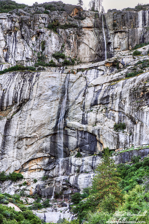
Patterson Creek Falls is 925 ft. high in two tall tiers. It definitely needs to be seen very early in the spring. At least I got to one waterfall on this trip. Would I see more in the morning?
Posted in Southern Sierra, Waterfalls by leapin26: April 25, 2022
Awhile ago my friend Jeremy told me about a better road to Bowman Lake than the horrendous Bowman Lake Road. I decided to try it out. I wanted to get back to Weaver Lake and I thought a backpacking trip there would be a great idea.
The new road is absolutely awful. Sorry my friend, it is awful. Well, I guess it is better than Bowman Lake Road, but that just tells you how horrendous that road is. I got to within 4 miles of Bowman Lake before I hit snow. I knew there would be snow and was hoping I could get to within 3 miles, so I figure 4 miles was pretty darn good. It would be a 7 mile hike from here to Weaver Lake. (6.7 miles to be precise). It is an easy hike and I arrived at Weaver Lake by about noon. It was a glorious day.
I saw a couple people at Bowman Lake but I did not see their vehicle. Did they drive up Bowman Lake Road? Is that road open yet? Normally that road is not open so early in the spring but I did see a lot of jeep tracks on the road I came in on. These jeepers can drive in the snow without difficulty. They can also leave a lot of trash. I know it was them because the trash was on the top of the snow and no one else has been up here yet this year besides jeepers. It is so bloody annoying. They have a vehicle. Why can’t they take their trash back with them? I must have picked up about 4 pounds (no exaggeration) and had to carry it out with me (on my back, not in my jeep).
No one had been up to Weaver Lake yet (but that would soon change). I found a great campsite at the outlet stream of the lake. It was absolutely beautiful. There were a couple Canadian Geese living at the lake here and I enjoyed their company for awhile. I ate my lunch and setup camp.
It was early so I decided I would go check out Weaver Lake Falls to see if I could get to it. I was definitely unsure about it. To get to the waterfall you have to first climb straight up a fairly steep cascade. At low flows it is not difficult but at high flows it is impossible. Right now the waterfall is at peak flow for the year and it most certainly would have been impossible to get up … however … there was a rope. With the rope I could climb up that cascade without too much difficulty, walking right up the middle of it in the water. It was fun! I made it up to the big drop, Weaver Lake Falls, 94 ft. high. Behind me coming up as well were a couple guys, I think the same ones I saw at Bowman Lake. I still did not see their vehicle so I guess they must have walked from Bowman Lake. They did not have proper shoes for climbing up the cascade but I am glad they did not leave their trash behind.
Now that I knew I could get to the waterfall I returned to camp for the rest of the afternoon and relaxed. I would come back in the evening to take my photos. My peace and quiet filled afternoon was rudely interrupted by jeepers who came up to the Weaver Lake area. They are so darn loud. I am so glad I made my campsite a bit off the road beside the outlet stream. I could still hear them but at least I could not see them.
After dinner I went back to the falls to take my photos. This time I was the only one there. Interestingly, a small tree had fallen down the cliff beside the cascade that you have to climb up. Did those two guys do that? It seems odd if they did that on purpose (not to mention stupid and dangerous). I have no idea what happened and maybe it was unintentional but they must have done something to destabilize the tree. Anyway I had a beautiful time in the evening at Weaver Lake Falls.
I got back to my camp at sunset and went to bed. It was a COLD NIGHT. The wind picked up tremendously. Not only was it cold but the wind made it much worse. I got almost zero sleep. Whenever I dropped off for a bit the wind would blast through and shake my tent all to bits, waking me up. I was not comfortable but not all that cold in my sleeping bag; I was prepared for the temperature but not for any cold wind. There had been no wind at all for this night in the weather forecast. I had been planning to do another hike in the morning but decided to nix that idea sometime during the night. I think it was a good choice with it being so cold and getting no sleep (and it would have been a hard hike). I woke up in the morning, my shoes were frozen (from climbing up that cascade), it was still cold and very windy, and not even my coffee could warm me up. I got back to the car by noon and drove home. It was a quick but awesome trip to Tahoe National Forest.
Posted in Northern Sierra, Waterfalls by leapin26: April 16, 2022
When life gives you liver, just take the onions instead. The philosophy of a madman. Ha ha.
I was not planning to go this waterfall at all. It was not even on the radar for this weekend but it turned out to be a pretty decent consolation prize.
I was planning to backpack down to the bottom of a certain secret canyon to see a certain secret waterfall. It was going to be awesome. The hike was about 9 miles one way. It was going pretty well. I had to make a couple detours and a couple off road bushwhacks but I made it to the top of the ridge. Now I just had to get down to the bottom. I had a good route mapped out. I was pretty sure I could do it but it is a 1200 ft. descent. It was killer tough. Very steep with lots of deadfall and bushwhacking. I made it down 1100 ft. I was cliffed out. You have got to be kidding me. There was no possible way to continue the rest of the way to the bottom. No possible route around the cliff. I was done. Oh man. I was bummed. I was beat tired. Now I had to bushwhack back up the 1100 ft. to the top and carrying my heavy backpack as well.
It took a long time to climb out. About 1 and a half hours. I was going very slowly. I bonked. Eventually I made it back to the top of the ridge. I certainly did not have energy to hike the 9 miles back to my car and go home. I had to find a place to camp. Near some water (which is quite lacking at the top of this ridge). A thought occurred to me. When I went to Onion Creek Falls last year I remembered hiking past a small stream on the way back. That would be a good place to camp for the night. It would be on the roadside (again) – another lovely camping location – not, but it was not far from where I currently was and there would definitely be water. In addition to this I could go to Upper Onion Creek Falls in the morning before I hiked back to my car. I had not been to this one before so it would be a good consolation prize.
The roadside camp was a little better than Breakneck Creek. At least this time I had a view overlooking the canyon. I setup camp, made my dinner, watched a movie, and went to bed.
The hike to Upper Onion Creek Falls in the morning was supposed to be very easy. So I thought. It would be an easy road walk to the top of the falls then a fairly easy descent down to the creek. Umm, not even close madman! I should know better by now, you would think. Firstly, there was no road. I had to traverse the mountain along a steep ridge through much brush. This is not what I wanted to do this morning at all. I was still tired from the day before. Secondly, when I finally made it to the falls I found not an easy descent down to the creek but instead an extremely cliffy hillside. There was no possible way to get all the way to the bottom of the waterfall. I very slowly and very carefully worked my way down the cliff. I had to use my rope at the end but I finally got down to a spot where I had a good view of the waterfall. Essentially I was hanging on to the edge of the cliff for dear life while I took my photos. But it worked.
Upper Onion Creek Falls is a fantastic waterfall and it is a lot bigger than I expected. I estimated it to be about 80 ft. high. It is a beauty but the access is crazy to say the least.
I hiked back up the mountain and found an easier way back to my campsite to collect my backpack. It was 9 miles back to my car and it was not easy with over 1000 ft. elevation gain but I made it back to the car by 2:30PM. Along the way I saw my first two bears of the year. They saw me first. I would not have even seen them but I heard a loud scratching sound and when I turned to look to see what the heck it was I saw one of the bears climbing down a tree. The second one was still up in the tree looking at me. They were young ones, perhaps a year old. I tried to get my camera out but he scampered down too quickly and then they were both gone. Ah well, it was a great ending to a very tough backpacking trip in Eldorado National Forest.
As for that secret waterfall? I will definitely be back some day to try again.
Posted in Northern Sierra, Waterfalls by leapin26: April 10, 2022
