I had a day off work. We went to Lake Tahoe again. I have done this hike before but Journey had not. So we needed to do it, right? I am glad we did. It is a fun little trail and Journey loved it.
On the drive there, not one but TWO cars turned into my lane and almost ran into me. The second one was on the freeway and I had to slam on my brakes to avoid a collision, which caused Journey to go flying into the back of my seat. This one really made me mad. Journey already hates car rides and she could have really been hurt. Put down your damn phones people. And look around when you switch lanes. How bloody difficult is that? Ok, sorry. End rant.
We arrived at sunrise. I could not park in the usual place because there were workers there getting ready to start their day cutting trees or something. Why are they working today? Isn’t it a holiday? I parked along the side of the road and we started our hike.
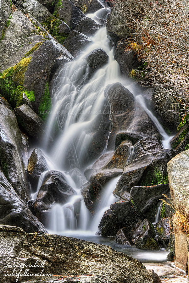
It is a short hike to the first waterfall, a small 20 footer but a pretty one. We continued to the big waterfall. I thought this would be the nicest one of the day and was planning most of my photos from here but it did not look very good at low flow, it is much better seen at high flows. I took a quick photo and we continued up to the third waterfall. I did not think we would make it to the upper falls in time before the sun was on it but we got there in the nick of time before the sun poked its head over the ridge. It was too hard for Journey to get all the way up to the bottom of it but we found a pretty good spot for me to take photos. Upper Upper Truckee River Falls. No, that is not a typo. This is the name of it and it is 35 ft. high. I think this was the nicest of the three waterfalls today (pictured here).
It is only about a mile to the upper falls. Neither of us were tired yet. It was definitely too early to go back. The trail continues on above the upper falls. I have not been up here before past the upper falls and I wanted to follow it as far as possible. The trail is not on any of my maps. How far does it go? It is a well defined trail though it does have some indistinct parts to it. It kept going and going. It went all the way to a small lake called Elbert Lake. This was a perfect spot to stop and sit down and eat a snack (which Journey did, of course). The mountain reflections in the lake were gorgeous. I don’t know if the trail stopped here or continued but we decided to go back down from here. It was a 5 mile hike in total. A pretty good distance for us today. It is an enjoyable little trail with zigs and zags and a bit of rock scrambling and log crawling and ups and downs in the pretty forest along the river. Zero people. Very peaceful. Journey had a lot of fun on this hike and so did I. It was a marvelous morning in Eldorado National Forest.
Waterfall hunting in Nevada. I have never been to this waterfall before because Reno “seems like” such a long way away. Actually it is only a 2 hour drive and all on the freeway. I thought about finally going here this weekend when I realized it would have Fall Colors and it would be flowing decent as well. It would have been much better to go early in the morning but I did not sleep well on Halloween night so we decided to go in the afternoon instead. “We” being myself and Journey of course.
This is a very busy trail. Much busier than the Galena Creek hike we did in Lake Tahoe. More people. More dogs. When I am sick and tired of seeing people before we even get to the waterfall then you know it is way too crowded. I am so glad that I can have Journey off leash when there is a lot of people. She is so perfect and follows right behind me or goes ahead of me past the people coming on the trail. When there are other dogs I do grab her collar or put her on leash and I had to do that a lot on this hike but I don’t need to do anything like that if there are no dogs. It makes me very happy.
It is a simple 3 mile hike (one way) to the waterfall with 1000 ft. elevation gain. It was a warm afternoon. There is a lot of Fall Color the entire way to the waterfall but no color right at the falls. There is some at the waterfall but it was long past done, unfortunately. The last section is extremely tricky. You need to cross the creek on logs which are quite high above the creek. We were following a lady and her little pipsqueak dog for this last part and her dog got right up on this narrow log with a big drop off and crossed the creek easily on it. Dang! It was incredible. No way Journey would be able to do that. The other option was a hodge podge of logs over the creek also with a big dropoff. They looked unstable and there were holes. You would not want to miss the log and put your foot through one of the holes, especially if you have little doggy legs. It seemed very sketchy. I looked around for another way but there was none. The creek was deep everywhere and would have been higher than Journey’s chest. There is no way she would have wanted to do that and indeed she would have balked and refused. Back to the hodge podge of logs. We need to try going this way. I got her up on the logs and she crossed carefully but easily. Awesome! I was very happy and proud that she did it. She is so good at stuff like this. My previous dog Kaya, no way Jose! She would have waded through the creek up to her chest.
I figured since it was late in the day there would not be any more people at the waterfall (except for the lady and her pipsqueak). Not so! There were still people here, including some kids smoking weed at the falls. I had to wait for them to leave before I could take photos. Then another big group came with a couple of dogs so I had to wait for them to leave as well. We sat on a log and ate our dinner while we waited. Finally everyone left. It was slightly tricky to get up to the base of the waterfall and we had to get our feet wet, but not nearly as difficult as the logs. We took our photos and enjoyed the waterfall before going back down.
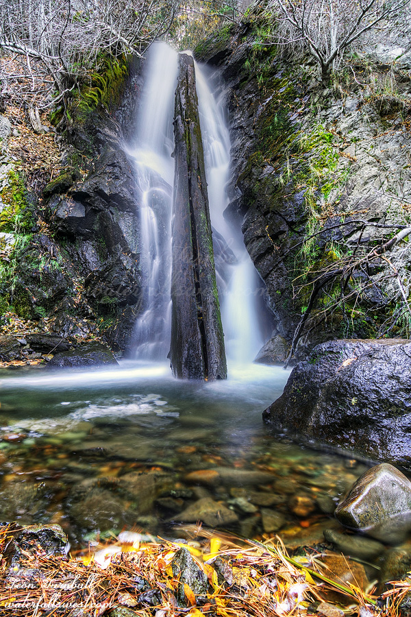
Hunter Creek Falls is 27 ft. high. It is a lovely waterfall and was flowing quite decent. Obviously it has a defining log in the middle, another one of those that adds a lot of character to the waterfall. My wife thought it was very similar to Lion Slide Falls and she is right, except obviously this one is a lot thinner.
We hiked back down the mountain. We saw quite a few more people coming up the trail. All of them would be hiking back in the dark. I think that is what I should have done as well. Do the hike later in the day and hike back in the dark. There would have been a lot fewer people. I will not do this hike again because of the all people on this trail. You can be sure that our next hike (whatever it is) will not have anyone on the trail. It was a lovely Autumn afternoon in Mt. Rose Wilderness.
Journey and I went up to visit our old haunt, Horsetail Falls. We went there last year together. Heck, I go there every year.
With the government shutdown, I should not have to pay for parking. Who is going to come check your car? A furloughed ranger? I don’t think so. Yet when I arrived at the trailhead every other car in the parking lot had paid for parking. What the hey? Do they not know there is a shutdown? Now I wondered if I should pay. Should I pay or should I go? If I go there will be trouble. If I pay it will be double. Honestly I did not feel like paying for parking today. If there is going to be a stupid government shutdown then I should get some benefit out of it. That is my logic. I did not pay. (and I did not get a ticket).
If you have done this hike you know there is a little bit of scrambling on steep, slick, granite rock. Journey did very awesome on this. I thought she was going to slip and slide a couple times, but no. She is an expert at the rock scrambling now.
By the time we arrived at the waterfall we were the last ones on the mountain. We went to a couple different spots for photos. I had an idea for something a bit different that I wanted but it did not pan out so here is your Horsetail Falls shot for the year. It actually is a bit different from my previous photos. Journey ate her snack and we hiked down, arriving back at the car at sunset. It was a lovely evening in Eldorado National Forest.
There’s nothing you can do to shut me out when I’m speaking the truth. – Kutless
Tara, Journey and I drove all the way to Yosemite National Park to play fetch. Ha ha. Well, not exactly.
The real reason we went is because I thought Horsetail Falls might be flowing and I wanted a photo of it in October. Two inches of rain this week. Yosemite Falls was flowing decent (it was dry earlier this month). A foot of snow at the top which would be melting. I really thought Horsetail Falls would be flowing, at least a little bit. We arrived at the park in the early afternoon. Horsetail Falls was completely dry. Shut down. Darn. Well, there are other things to do in Yosemite, right? Such as play fetch!
Journey was antsy after the long car ride. She needed exercise in the most severe way. As I have said before she is a very high energy high maintenance dog. We love her to bits but she needs exercise every day. We stopped at the El Capitan picnic area and found an awesome spot for her out of the way from everyone else. We put her on the long rope and fetched. ONE AND A HALF HOURS. Pretty much non-stop. After an hour we tried to get her to stop and lay down for awhile but she was like: What are you doing? Throw that ball already!
Of course as you know, Yosemite National Park is in shutdown. I have read horror stories in the news recently as I am sure you have: base jumping off El Capitan, squatters, etc. Let me tell you what I saw there: I did not see anyone base jumping and we were there for the entire afternoon (I’m not saying it did not happen). The campground we passed was pretty full and I am sure some people (maybe a lot?) were there illegally. This did not bother me, though. If people were squatting illegally along the Merced River or some other such place, then that is different. I would have been mad about that because it is an environmental issue but if they are in the campground, who cares. There were quite a few people in the park overall but nothing out of the normal. The shuttle bus was running regularly. I saw one ranger making his rounds through the valley (a couple times). The bathrooms were clean and stocked with toilet paper. There was no overflowing garbage anywhere. Frankly, I was surprised. Very surprised. And very pleased.
Another thing I was surprised about was that the Fall Colors were already showing in the valley. Mid October is very early for color in Yosemite Valley. Indeed, I have a friend who was just there a few days before me and I asked him specifically if there was any color yet in the valley and he said none. Ugh! There was a lot of color! If I had known this then I would have come early in the morning at sunrise and spent more time in the valley photographing the colors. Ah well, c’est la vie.
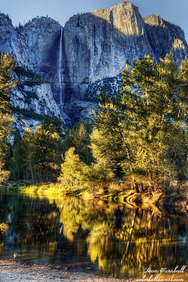
At 3:30pm we went to see the Lower Yosemite Falls. This is one hike (walk) which Journey is allowed to go on. Tara is on crutches at the moment so we took it easy walking up to the falls but she made it. There were a lot of people there. All over the place, including up on the rocks near the waterfall. Even someone climbing up beside the waterfall (which I did not even notice until I got home and looked at my photos). There was no way to photograph the lower falls back at the viewpoint because of all the people so I had to scramble up on the rocks as well. Amazingly I found a pretty good spot with no one else in my viewpoint even though there were a ton of people all around me. After this, we drove all the way back around the valley again and stopped at Swinging Bridge to take this photo of Upper Yosemite Falls. We stopped at Bridalveil Falls viewpoint on the way back but I did not take photos there. Then the long drive home. It was a glorious afternoon in Yosemite National Park amidst the government shutdown.
Mom was out of town for the weekend so I had Journey. A big hike was certainly in the plans (actually, multiple hikes). I wanted to see some Fall Color this weekend but I definitely did not want to drive all the way to the Eastern Sierra. Maybe Lake Tahoe? But where? I read a couple reports that the hike to Galena Creek Falls had Fall Colors. What? I have done this hike before and never noticed any such thing. Well, perhaps I should go and see for myself once and for all.
We arrived at the trailhead Saturday afternoon. It was extremely cold! It was 39 degrees and there was a cold wind blowing. I was not expecting this at all. I did not have my toque or gloves. I did have my jacket and long pants, thankfully. I have a friend that absolutely refuses to wear long pants before November no matter what the weather is like. I am kind of like that but not so strict. If it is very cold I will wear long pants. It was very cold.
The trail is a very busy one. I was indeed expecting this and I figured I would have to have Journey on the leash for most of the hike, at least up to the waterfall. However, when we reached the sign that said dogs can now be off leash, I decided to let her go. She is very good about staying with me. She is also quite skittish of other people on the trail. Normally we do not hike in places where there are many other people (or any other people). At first, as we came up to someone she would say “daddy, you go first”. Later on, she got better about this and would go ahead but if the trail was narrow she would still want me to go first past the horrible people. (ha ha)
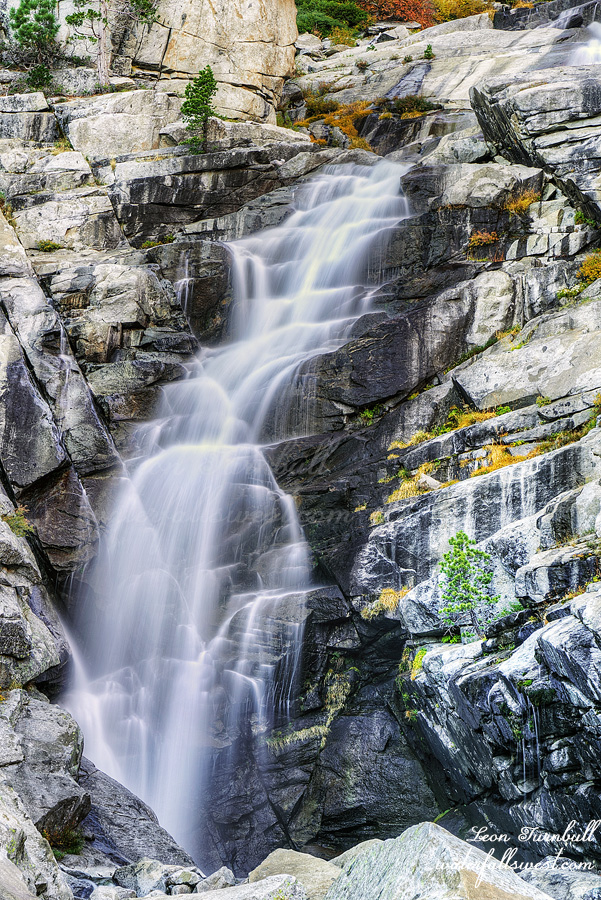
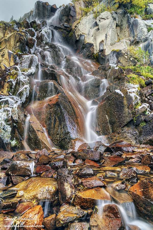
We arrived at the waterfall and it was in shade (due to overcast weather) so we stopped and I took my photos. Galena Creek Falls is 60 ft. high and it was still flowing fairly decent in mid October. There was ice around the falls which was also quite interesting. Did I mention it was cold?
There are no Fall Colors on the trail to the waterfall. I was not wrong in what I remembered about this hike. There are Fall Colors, however, if you continue past the waterfall. Initially I thought about going all the way to the Mt Rose summit but then figured I did not really want to do that. We could, however, continue past the waterfall and make a loop to extend our hike from 5 miles to 6.5 miles (total). That is what we did. Along the yellow brick road. There are not any Aspen here so the colors are not exactly super spectacular but nonetheless there was some very nice yellow. As we climbed up the mountain I was breathing with much more difficulty. The elevation was 9350 ft. and it was definitely getting to me. I saw no evidence of any tiredness in Journey as she rambled on ahead of me. Eventually we came back down to the waterfall where we ate our dinner. On the hike back down to the trailhead it started snowing! Just some small, light flakes, but it was snowing. It was also sunny directly overhead so what the heck was this nonsense? Ah, well there were some dark clouds over yonder and with a strong cold wind it was blowing the flakes into our path. We got back to the car at about sunset and drove home. It was a cold and beautiful afternoon in the Mt. Rose Wilderness.