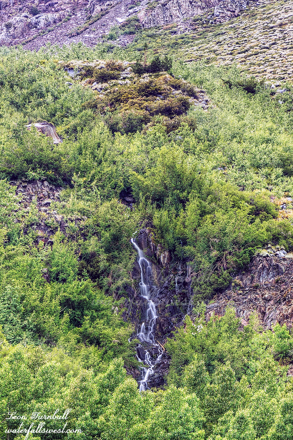
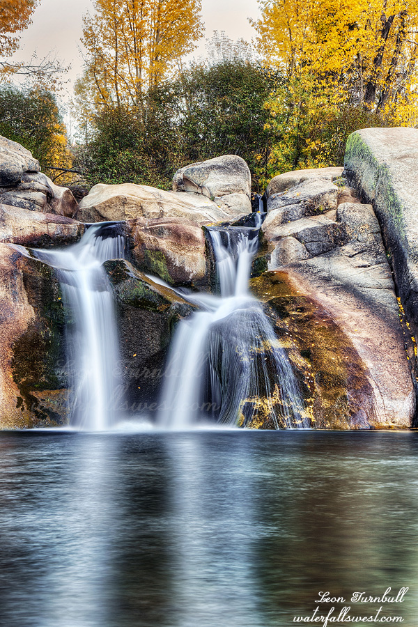
This is Tom’s Waterfall. I don’t know who Tom is but he has a place and this waterfall is near his place so it must be his waterfall. I’m kidding. This waterfall is actually named Horsetail Falls but there a million Horsetail Falls in the world so this one should have a different name. That is what my wife said, anyway.
I was not planning to go here. I wanted to hike in the Lee Vining area. One word: thunderstorms. I checked the forecast before we left home. There were supposed to be thunderstorms in the afternoon but it looked to be clearing by 4pm. That should be perfect for my planned hike. We drove to Grant Lake in the morning and found a nice little beach with a bit of shade and played fetch with Journey. All morning long. She completely wore herself out but I was not worried about our afternoon hike. All she needs is a short rest and she is ready and roaring to go again. At lunch we went to Whoa Nellie Deli (a required stop at Lee Vining). Sadly it is no longer called Whoa Nellie. Maybe we should rename it to Whoa Journey. I checked for the updated forecast. Not good. Now it looked that it would be thunderstorming all afternoon and not stopping until well into the evening. I would not be able to go on my hike now. We would just have to drive back home. I don’t mind hiking in the rain but thunderstorms are a different beast. Plus I had Journey with me. She definitely would not want to hike in the pouring rain.
Down by Mammoth Lakes, however, it seemed that the rain would be stopping before 4PM. I could do the hike to Horsetail Falls down by Tom’s Place instead. I have not been to this one before and I was sure the waterfall would be flowing decent as the creek is a good sized one. We drove down to the trailhead and it was raining so we sat in the car and waited. Finally at about 3:30PM the rain let up. It was still drizzling or lightly raining but it seemed to be stopping so I figured we should start the hike. Tara waited in the car while Journey and I hiked up to the falls.
I had to keep Journey on the leash up to the waterfall. She did not want to hike today. It may have been partially because she was tired from playing fetch or because it was still raining, but mostly I think it was because she wanted mom to come with us. She did not want to leave her behind. It is strange because we did this exact thing at Lake Tahoe a couple weeks ago and she was great on that hike. She was perfectly fine hiking with me once I put her on the leash and once we got up close to the falls I took it off and she was great for the remainder of the hike. On the return hike down the mountain she was anxious to get back to mom quickly and was running way far ahead of me. But whenever I called for her to stop and wait for me to catch up, she would. Whoa Journey! She is such a good dog.
Horsetail Falls (this Horsetail Falls) is 75 ft. high. I have never seen any photos of it before which is odd because it is right along a very popular trail and you can easily see it from the trail. I was disappointed with the flow. As I said I was sure it would be flowing decent. Even when I looked at the map when I got back home it looks like a good size drainage. I don’t understand why it was so low. Anyway I do not regret coming here. I would not have been able to do any hike in Lee Vining that day and I had not been here before so it was worth coming here. I am sure I will be back some day. It was a fantastic day in the Eastern Sierra.
I arrived at the Leavitt Meadow trailhead to the sound of Thunder.
Big Thunder. Lightning. Hail. Huge Hail. Pebble Sized Hail. I took shelter in my car. It pelted the windows. I almost thought they might shatter. I would not want to be standing outside in this. Or hiking in this. The hail continued for about an hour. Followed by a steady rain for another half hour. So much for being one and a half hours early for my hike. There were another couple guys and a dog parking next to me that did the same thing. Waiting for the rain to stop before they started their backpacking trip. Finally the rain stopped at 6:30PM. I had cell service so I kept checking the radar during this time. It seemed that no more rain was coming for the evening so I got all my gear together quickly and started my hike. It was perfect timing, really. I would not have wanted to start hiking any later than this. In fact, if the rain had continued any later, I probably would’ve slept in the car and did the hike to the waterfall in the morning. But I didn’t want to do that, I wanted to backpack in and camp at the waterfall. It turned out to be a very pleasant evening hike. Cool temperatures with a nice breeze. The sagebrush had a wonderfully refreshing smell. There were a lot of puddles on the trail from the rain. There were no bugs. There were mosquitoes near the end as I hike through the forest after the breeze had stopped and I had to put on bug spray but when I got to my camping location, there were not many bugs there at all. I arrived at sunset, 8:30PM. Unfortunately, there was no easy access to water at the top of the waterfall but thankfully, I had enough water left to last the night. Barely. I would get more in the morning when I went down to the waterfall. I set up camp in the dark. It took longer than normal because I was using my old tent and it had been awhile since I have set it up (remember, my good one died on the last trip). I hopped into bed and went to sleep.
The forecast said it would rain more in the night, and more in the morning. I did not care about that, so long as I could take photos of the waterfall in the morning before the rain started. However, that did not happen. It did not rain at all. I slept fairly well, and woke up to an absolutely gorgeous morning. No mosquitoes at all. It was perfect. Thank you, Lord.
I scrambled down the steep hillside to the river. You have to cross the river to see the waterfall. This is the reason I did not bring Journey on this trip. I thought the river would be a lot higher and I figured she would not be able to cross it. As it turned out, the river was a lot lower than I expected. I think she could’ve crossed it. But she definitely would not have wanted to cross it. It was deep enough and slippery enough that she would’ve had troubles. Maybe it is a good thing I left her at home.
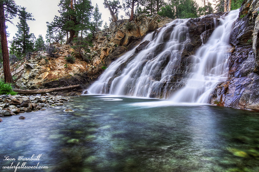
I spent a lot of time taking photos from different angles. West Walker River Falls is a beautiful 33 foot high waterfall. It is well hidden and off trail. When I was here a few years ago I walked right past the waterfall not knowing it was even there. Shame on me. I suppose I probably would’ve figured it out eventually but many thanks to my friend Mike who told me about it. After taking photos I gathered some water and hiked up the hill to my camp, made some coffee and enjoyed the beautiful morning.
On the hike back, I passed some people with a pack of horses. They told me to go way up the hill off the trail because they had a skitterish horse. Thankfully, there was a place to get way off trail. What if it was a much narrower spot? Anyway, one of them asked if I saw the beaver at the waterfall. There is a beaver at the waterfall? I never saw it, but it would’ve been cool to see one for sure. All I saw this time were some deer. I arrived back at the car at 10:30AM and drove home. It was a magnificent one night trip into the Hoover Wilderness.
A day off work. Some much needed stress relief. My plan was to go for an overnight trip to Sonora Pass and see a couple new waterfalls. I left home at about noon and arrived in late afternoon.
The first waterfall was an easy one and about a one mile hike along a rough dirt road. There were a lot of trucks driving up the road. It was almost like a freeway. Not for me. I just parked at the highway and walked up the road. Much more pleasant this way. Once at the creek, I scrambled up the creek to the waterfall, crossing back-and-forth a few times. Easy as pie. Apple pie.
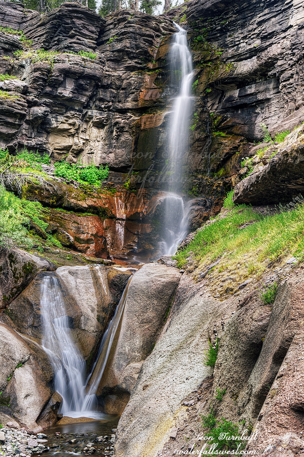
Upper Leavitt Falls is a very lovely 71 foot high tiered waterfall. There was a storm coming in and so with clouds overhead, I was able to take photographs of the waterfall early. In fact, I was now about 1 1/2 hours early for my second hike. This was a good thing. It meant I would not be hiking in the dark. Unless I had any delays. Such as …. (Part 2 coming) …
Well … where should I begin? I injured my neck. Over the last month or more I have been in incredible pain. I have not been able to sleep well. The pain has gone down into my shoulders and arms now. I am 99% sure it was injured when I was rafting to Lake Eleanor Falls. It was quite windy and choppy and I had to work very hard at the paddling to the waterfall and back. That was around May 1. After that trip, the pain started but it was not very noticeable at first. It did not even occur to me it was caused by the rafting. I was still able to hike. We went to Shelter Cove on our anniversary trip. I made the big backpacking trip to Kendrick Falls. I was taking pain killers but I had no problems on that trip. The neck kept getting worse and worse. It was not getting better. I could not hike any longer. I had to go to the doctor. That is always a big ordeal. He just said go get an x-ray and come back in a week. So I did. Then he basically said I have arthritis in my neck and should do neck exercises. Humm …
Only in the last week has my neck finally started to get better. I feel like it is finally healing now. I wanted to get out hiking one last time. It is going to be 180 degrees or something ridiculous next week and for the week after that as well. The apocalypse is here. This would be my last chance to hike for the summer. If my wife and mom find out, they will say I am stupid for going hiking! There will be a fallout. Well my wife did not say I am stupid but my mom might when she reads this.
I decided to go to the Eastern Sierra for the day. Almost all the waterfalls there face towards the east (which should be obvious, it is the “Eastern Sierra”), and that means they all get very early morning sun. I did not have any desire to get up at some God awful hour to drive out there for sunrise so my plan was to hike in the evening. I would arrive at about noon, eat lunch at the Whoa Nellie Deli (which is not called that anymore, sadly) and wait around for five hours until evening. I intended to go on a different hike first but when I arrived I discovered my planned route was all blocked off with fencing (private property). I could have gone to this particular waterfall via a longer route but then I would not have had time to do the second hike. I did not think it was worth it, so I just went to the second one instead: Chouinard Falls.
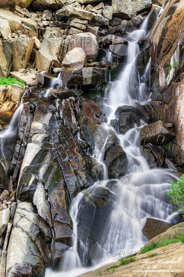
I have wanted to try this one for some time. I thought I could get down to it from above, from the highway. It is steep and dangerous. The rocks are all very loose. Once down the rocky section it becomes very brushy. The mosquitoes were out in force. Wait. Why are they out? Wasn’t it supposed to be windy today? Why isn’t it windy? What happened to that wind anyway! Well, it was pretty windy up on the highway but down in the brush, not so much. Dang those blood thirsty buggers! I made it over to the waterfall. The top tier is shown here, 46 ft. high. There is a second tier about the same height but I could not get down to it. It was just too cliffy. I thought I’d be able to do it, but it was a no go. I was shaking as I took photos and had to be extremely careful near the cliff edge. It was a tougher hike than I expected and it was over 9000 ft. in elevation. I was definitely feeling the effects of the high altitude and was out of breath and feeling wheezy. I was also expecting a lot more flow. According to the Mono Lake website it should be flowing at 140 cfs. This is certainly not 140 cfs. Apparently I misread the information. I thought the 140 was the intake to the powerhouse, but actually I think it was the outflow from the powerhouse (even though it says intake). Ugh. I still think it should have been better flow than it was.
I returned up the steep rocky slope to the car and drove home, arriving at about 11PM. I had to get up for church at 6AM since I was playing in the early service. Not much sleep for this old man but coffee helped. It was a nice day out in the Eastern Sierra before the apocalypse arrives next week.
I did not sleep well. The wind died down in the night but then picked up with a vengeance in the very early morning hours. The forecast said the wind would be a casual 20 mph, the same as the previous day. That is what I was expecting. Instead it was a gale force. It was cold. It was howling. This was not in the forecast whatsoever. Argh those weather forecasters. I tried to make my breakfast but it was difficult to keep the stove on with no shelter from the wind. It seemed to be blowing in all directions at once. It took quite awhile but I managed to heat up the water enough so I could have my coffee.
I went down to the river to get more drinking water from the toxic algae infested waters for the hike out of the canyon. I was glad I took my photos of the lower falls the previous evening since it was so windy now. I was really pleased about the pretty fall colors above the waterfall. The only fall color I found on this hike was at the bottom of the canyon near the two waterfalls. I was hoping for more but at least there was some.
There was a winter storm coming in the afternoon but I hoped to be back at my car by noon before it started. Climbing out of the canyon was excruciating with the gale force headwind. It was very cold. Once I got off the ridge and into the trees it was a bit better but I don’t like hiking in high wind. At one point I heard a sound like thunder. I did not see it but I am pretty sure it was a tree snapping like tinder in the wind. Surprisingly, I came across two groups of day hikers. I am not sure how smart it was for them to be hiking down to the bottom of the canyon in this wind and with a storm coming. Perhaps they didn’t mind hiking in the windy conditions, but I really don’t think they understood what was coming. When I got back to my car the snow was just starting (two hours earlier than forecast). The wind was even stronger now and the snow was blowing all over the place. It was a full on blizzard. Incredibly, there were a couple hikers just starting up the trail in the blizzard. Are they really planning to go all the way? I should have asked them but I was too cold. I quickly escaped into the comfort of my vehicle and cranked up the heat. Whew. It was a wild and crazy adventure to Rainbow Falls in Ansel Adams Wilderness!