
WATER? WHAT WATER?
This hike has been on my list for a couple years but I was not planning to do it this year. One word: FIRES. I was initially planning to go to Mt. Shasta this month (August) but that is clearly out of the equation now due to the fires up north. The reason I wanted to go to Shasta is because the waterfalls there are glacier fed waterfalls and so they flow in the summer. There is pretty much nothing else flowing now in California because of the drought. But wait! The waterfalls at Lake Catherine in the Ansel Adams Wilderness are also glacier fed. I know they are flowing because I saw some recent pictures from someone that was just there. I have not been to them before. There are no fires there. Perhaps I should go now. And so I shall!
I was surprised there were permits still available for this location because it is a popular place. Not Lake Catherine, but Thousand Island Lake is extremely popular and it is in the same permit area. I took advantage and snagged a permit. I decided to start from Rush Creek mainly because I have not done that trail before. It is more difficult (1000 ft. more elevation) but I figured I could handle it. I have not hiked at all in two full months (since the High Sierra Trail in early June) but I have been working out every day. Long story short: I totally underestimated how difficult this hike would be. That was my first mistake.
It is 3000 ft. elevation gain from June Lake up to Thousand Island Lake and then an additional 1500 ft. to Lake Catherine. That’s 4500 ft. elevation gain! I took my heavier tent because I knew it was very rocky at Lake Catherine and I knew of only one very small campsite there. The Z packs would not do well in such a spot. Well, that was my second mistake. I could have planned this entire trip just a bit better. The Z packs would have been fine.
The permit office did not open until 8:30am and I was first in line. I got my permit and started my hike by 9:30am. Not too bad. It is a relentless climb. I arrived at Thousand Island Lake at 3:30pm. I was beaten. Honestly, there was no possibility of getting to Lake Catherine today. I was so tired. Plan change. I hiked to the far end of Thousand Island Lake and found a campsite. 99% percent of people camp at the near end of Thousand Island Lake. Who wants to hike all the way to the end? No one does. That means I had the area all to myself. Well, almost. There was one other person there but he was not too close to me. It was a bit strange where he camped. He was a long way from the lake and basically had to walk a full quarter mile just to get water from the lake. Why would you want to camp so far from water when you don’t have to?
My new plan was to stay at this spot at Thousand Island Lake for two nights. I would do a day hike to Lake Catherine the next morning. That meant I had to get up and start hiking in the dark if I wanted to get to all the waterfalls before the sun. Once again, I totally underestimated the hike. It starts out quite nice and although it was dark it was easy going and I even found a trail. Then … we come to the boulder field … The trail disappears. The terrain becomes much steeper up to North Glacier Pass. Basically you have to climb straight up the boulders to the top of the pass. It is difficult. It is dangerous. It is slow going. Just when I thought I was at the top I find out it is a false summit. There is still another 100 ft. of boulder climbing to go. Holy macaroni that sucketh. It is now getting late and I realize there is no possible way I will get to all the waterfalls; nonetheless, I can still get to some of them. I finally arrive at the summit and get my view of Lake Catherine dwarfed below Banner Peak and Mt. Ritter, with Lake Catherine Glacier sandwiched in between. I was expecting a lot from this viewpoint and it did not disappoint. Lake Catherine is most definitely one of the most beautiful lakes I have encountered. The color of the lake from the glacier water is stunning, especially once the sun comes out. The scene is magnificent. I could sit here all day but time was running out and I had waterfalls to see.
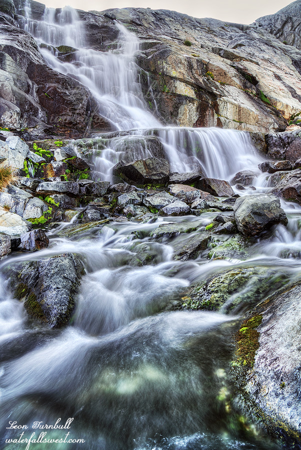
The terrain on the other side of the pass is no easier. It is a 200 ft. descent down to the lakeside and then another wild boulder scramble along the lake to the end. From what I could see the glacier was not melting. Would the waterfalls even be flowing anymore? I was a bit concerned. However, when I got to the outlet stream my worries were alleviated. There was still plenty of water in the creek. Even though the glacier may not be melting at the moment it must have been melting enough when the temperatures were hotter a few weeks ago. I made it down to the first waterfall, Upper Lake Catherine Falls, a very gorgeous 40 ft. drop. What a stunning sight to come and see in this drought stricken summer in California.
I still had a couple other waterfalls to see and time was running out. Stay tuned …
August 24th, 2021 at 6:41 am
“Holy macaroni that sucketh”. I nearly spit my coffee out in the laugh I had over this one!
I guess a 4,500 foot vertical keeps the permits available. I need to kick up my weekly workout routine. Looking forward to the next post.
August 24th, 2021 at 6:42 pm
I’m glad I amuse you. I amuse myself too. LOL. Thanks for your comment, Mitch. 🙂