I had a permit for Yosemite this weekend but I decided not to go. The reason was because the river was still too high and there was still too much snow. I had one major creek crossing which I was sure I would not be able to do, but more than that there was still snow on the very steep slope going down to the creek and I was afraid that would be extremely dangerous. I decided to go elsewhere. After too much debate (ask my wife) I decided to go to Canyon Creek Lakes in the Trinity Alps Wilderness. I have been to the waterfalls on the main creek before of course, but I had not been to the ones above the lakes. This seemed like as good a time as any.
It is a long drive from Sacramento. I arrived at the trailhead at 8:30am and on the trail before 9. There were six cars already at the trailhead. It is a popular hike but I did not expect to see that many on a weekday. I passed five of the groups and the other was already up at the lower lake. It was a rather interesting hike overall. At least the end of it was.
I have hiked the trail up to the lower lake before. It was not brushy or overgrown whatsoever. I am certain of it. Now it is completely overgrown. It is impassable. What the heck? How could anyone hike this? This is a very popular hike! I tried to brash my way through it. Impossible. Utterly impossible. I gave up. I decided to try to go up by the creek. Perhaps that would be easier. Nope. Way overgrown beside the creek as well. Not do-able. I did not know what to do now. How was I possibly going to get up to the lake?
As I turned around to go back down I saw a couple of the guys I had passed and they were crossing the creek on logs down below me. Huh? I asked them is this where the trail goes? One of them responded, Yes I have the route on my AllTrails. Alrighty then! Normally I would not trust AllTrails with a ten foot pole but in this case it was correct. This was the trail. I should say this is the “new trail” because the “old trail” which I have hiked before is now impassable. I crossed the creek and followed them up to the lake. If it was not for these two guys, I honestly would not have found the trail at all. Maybe if there was no snow covering up the trail it would have been different (I am not sure).
Now I had to hike up to the upper lake. This was very difficult. Once again, I went the wrong way. I went the much harder route and ended up having to climb straight up the mountain. I made it up but what the heck is wrong with me? I found the proper route on the way back down. It was much easier.
At the upper lake I caught up to the day hiker that had passed me earlier. Now I was all alone. There was no one else up here. I crossed the outlet stream (which had quite a strong flow) and continued to the end of the upper lake (it was not easy). It was extremely brushy getting down to the lake. Once again I think I went the wrong way but the “proper route” looked far too dangerous to me on the wet slippery rocks. I continued up past the first waterfall, looking for a campsite.
There are three waterfalls up here and along the way I found a beautiful fourth bonus waterfall. I love bonus waterfalls! I found a terrific campsite at the top of the fourth waterfall. Four amazing waterfalls right here, all within view of my campsite (mostly) and all (fairly) easy to get to. I was going to have a fabulous evening.
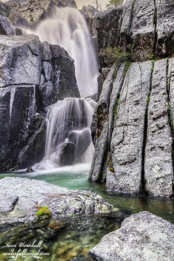
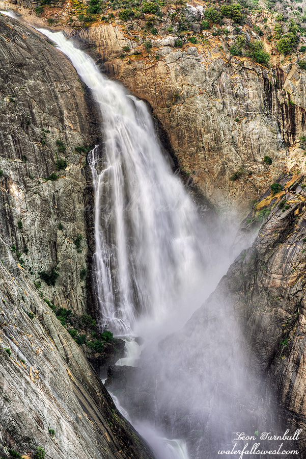
The first of the four waterfalls I went to after dinner was Third Canyon Creek Lakes Falls (pictured here). This one was very fun to get to. Fun Fun Fun. There was a trail going right up to it. I was shocked to find this trail. I did not think anyone would ever come up here, it is so remote. The trail goes down to the creek at the bottom of the falls at which point you need to cross the creek in order to see it. I found a very slick and sloped rock to sit upon while I gingerly set up my tripod to take photos and try to not slip right into the deep creek. Third Canyon Creek Lakes Falls drops 82 ft. off a cliff down into a narrow alcove. It is absolutely stunning.
After this I continued on to the other three waterfalls and then went to bed. It was an amazing first day in the Trinity Alps Wilderness but the next day would be a very different story…
So long story short … yada yada yada … we had to get rid of our Jeep and buy a new vehicle. We bought a new Kia Telluride, shiny dark red. It is sweet and fancy. I am naming her Pepper, short for Dr. Pepper (the can is the same color). Tara does not like this name, although she was the one that suggested it. Go figure. Of course for her first adventure I had to go up Foresthill Road to the New York Canyon area. The last adventure for our old Gator was here. The first and last adventure for our Jeep was here. So the first adventure for our new car will be where? You got it.
I wanted to try to get to the lower falls on West New York Canyon Creek below the main waterfall. I thought I could do it. Huh.
There was still a little bit of snow left at 6600 ft. elevation but not much. Descending down into the canyon there is a lot of brush. My legs got all scratched up. Is it my imagination or is there a lot more brush than before? I was just here last year! I was scared of all the brush. What I mean is I was scared of stepping on a rattlesnake. I have already almost stepped on four of them this year. I have hiked down here a few times before and never given it a second thought but this time I am freaked out of my mind of stepping on a snake. Thankfully the brush gets a lot less the further you go down. It is a 1500 ft. descent.
I got down to the viewpoint of the main waterfall. I thought that if I could just get past the first cliffy part at this spot then it would be a cakewalk. According to the Topo maps it should be pretty easy. Well, I got down past the first part all right. Then I hit a real cliff. No further entry down into the canyon was possible. Dang. I retreated to the main waterfall viewpoint. I had two hours before it would be in good light. I did not want to wait here two hours. I already have a decent shot of this one. I went back up the mountain.
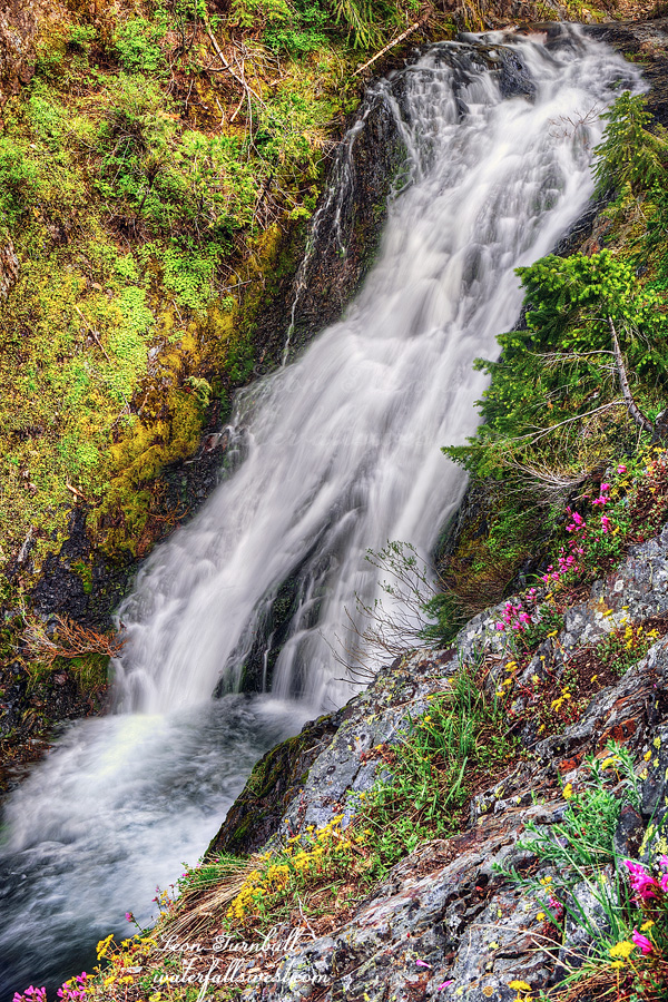
On the way down, there was another waterfall I saw on the eastern branch of the creek. I had not been to it before and it looked like a real nice drop. It was much easier to get down to this one and I got right to the brink of the waterfall. I only had to wait an hour for the sun. I sat down on the rocks and ate my dinner along with the ants and mosquitoes. (actually, there were only a few mosquitoes but I did put on bug spray to keep them away).
The waterfall is 38 ft. high. It is a very lovely cascade and especially nice because there were pretty wildflowers along the edge of the cliff in front of it. I took a few photos from different angles. It took 1.5 hours to climb back up the mountain to my car. It was a fantastic first adventure for Pepper in Tahoe National Forest.
When I was here a couple weeks ago there was a new waterfall I found that I could see from Sailor Flat Road. I’ve seen it in the past but never had a chance to go there. I was hoping to get to it on the morning after I camped at NYC Falls but by the time I got there it was already in the sun. It looked like a big waterfall and it was flowing well. It was time for a return trip. It should only take a minute.
I was definitely not going to hike all the way from Ford Point again. Thanks to a friend of mine that is in the know, I knew that Foresthill Road had been closed because the county was still plowing. I also knew from him that they had finally finished plowing the road to Robinsons Flat and so now the road was open for the summer. I would be able to drive all the way to Sailor Flat without any issues.
I headed out one evening after work. It was the middle of the week and I saw no one on the road at all. Except … I passed one vehicle that was “parked” just off the road near Tadpole. It was 5PM. There was a lady and a couple kids. It looked to me that they were up there playing in the snow. Hmmm … I continued driving to Sailor Flat. It had only been about 1.5 weeks since I had been up there. Most of the snow on Canada Hill was now gone! In just 1.5 weeks! That is some crazy snow melt.
I got to Sailor Flat, parked, and donned my snow shoes. Snow shoes were needed. There was still plenty of snow. I would not be hiking all the way down Sailor Flat Road. That route would be too difficult to get to this waterfall. I had a different idea. In short order I came across my second bear of the year. This was a small brown colored one and it ran away when it saw me. Just like it is supposed to do. (unlike the earlier one I saw this year). I think I did get some video as it was running away.
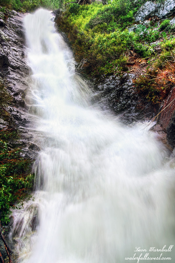
It was not difficult to get down to the waterfall. The snow had disappeared and I had taken off the snowshoes. It was not cliffy. However … getting a view of the falls was a lot more difficult than I anticipated or hoped it would be. It was extremely brushy beside the creek. I had to clamber through very thick brush on a steep slope to get to the creekside. I crawled out on a log in the middle of the creek and I finally had a good view, but at this spot it was very misty so it was a huge challenge taking a photo. I managed to get something.
I’m not so sure it was worth the effort. This waterfall I am calling Upper New York Canyon Falls East. It is 53 ft. high. It looked a lot bigger from a distance on Sailor Flat Road. Anyhow, it is an interesting one. I climbed back up the hill and to my car.
On the way home as I got back to Tadpole I saw that the lady and her kids were still there. It was 3 hours later. I almost passed them by again without stopping. It did not occur to me that they could have been stuck. They were parked just two feet off the main road. As it turned out they were indeed stuck and there was no possibility of pushing the car out of it. Thankfully she said there was someone on the way to help and it would not be very much longer, so I said goodbye and left. It kind of boggles my mind why she thought she could drive up this road with so much snow on it. She literally drove two feet and was completely stuck. Sigh.
So remember a couple weeks ago I said I was really bummed because on the day I was planning to go to this waterfall they turned off the tap? Well they turned the tap back on this week. I figured this would be my one and only chance this year to see this waterfall. It was Memorial Day weekend.
What the hell was I thinking!!! I never go anywhere on Memorial Day weekend. There are too many people. I hate crowds. I hate horrendous traffic. Driving down to Shaver Lake the traffic was absolutely horrific! I was stuck going 5mph for about 50 minutes. I had enough. I was ready to go home. Once I finally got past this section I exited the freeway. I needed a break. I needed a bathroom break. I needed a dinner break. I needed a reset. Well after checking my map I figured it would be a two hour drive back home. And it was two hours to Shaver Lake. Going back the traffic would definitely be bad. Continuing on it did not seem there were too many more slow spots. I felt recharged a bit after dinner. I decided to continue.
When I arrived at Shaver Lake I needed to find a place where I could sleep in my car. Off the beaten path. With no one else around. On Memorial Day weekend. I drove to the place where I would be starting my hike in the morning. It was a good spot to park and sleep. No one else was around. Indeed I saw no one at all out in this area the entire weekend. I was shocked. It is Memorial Day weekend! I definitely expected to see some people out camping or hiking somewhere the next day. Nada.
I got up at 4AM to start my hike in the dark. I had until 7:30AM to get to the waterfall and I figured it would take 2-3 hours to get there. I had to make sure I had enough time. So off I went in the dark.
In very short order I came across a massive road block. Actually, it was a road massacre. There was no road! A flood had completely wiped it out. There was a small stream running down the middle of the road with 30 ft. canyon walls on each side. I am not exaggerating. This new canyon was probably created in just 2 or 3 days. I had the understanding that this road was closed due to damage from the Creek Fire and that may have been the case but now it has been destroyed by a flood. I suppose it could have been from 2017 floods but I suspect it was from this year considering all the other damage that has occurred this year, especially in Sierra National Forest (where this is). It is incredible what a small flood lasting just a couple days can do. I wonder what a massive flood of 40 days and 40 nights could create? Oh yeah, we can see the result of such a flood now, can’t we? It’s in Arizona.
Anyway, I was really wondering if I could even get by this little canyon, in the dark. Fortunately I was able to. After this, however, the road did not get any better. Every small stream coming down the side of the mountain (whether it was still flowing or dry) had taken out a massive chunk of the road. The damage to the road overall is unbelievable. I was able to get by all these sections, however, there was one spot that was very narrow and I had to crawl on my hands and knees. Coming back across this section later was a lot sketchier than I thought it would be, with a big drop-off to the side of it. Crawling would not work so I had to jump across the drop-off. Do you think I am a Madman now???
As the sun came up I could now see across the canyon to my left and hear the river roaring. Oh wait, that is not the river. That is Stevenson Creek! The views along here were spectacular. I had no idea Stevenson Creek flowed through such a beautiful canyon. It would be a great place to camp. The upper falls was looking very impressive from a long distance but I would not be going there today. I continued down the battered and beaten road.
I had to exit off the road now and descend about 500 ft. to my viewpoint. I could see the waterfall from near the top and could have taken pictures from there but I could not see the bottom of the waterfall so I wanted to make the effort to get all the way down as planned. It was not cliffy or brushy but the foxtails were horrendous. I should have been wearing gaiters. I was not wearing gaiters. Ugh. I made it down to the viewpoint. It was 6:30AM. (an hour ahead of schedule).
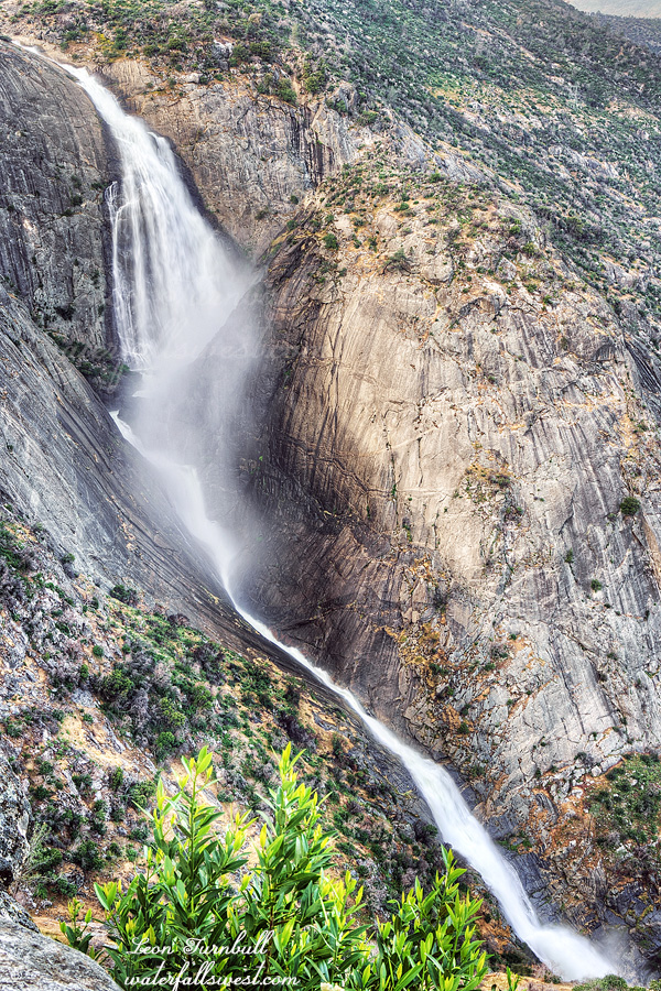
Stevenson Creek Falls was massive! Wow! What a view! What a waterfall! The flow in the creek was 500 cfs coming out of Shaver Lake. This upper drop I measured to be 518 ft. high. I could also see the lower falls dropping onto the bridge from here. I could see the entire 1175 ft. waterfall from here. I took many photos. This is the first one, just showing the upper massive drop. I could see the waterfall overflowing onto the bridge below. I did not see any people down there (I wondered if there would be any but I guess not at 6:30AM). I have seen recent posts from people going to the lower falls and then not being able to cross the bridge because of all the water overflowing onto it. I have done that before myself. It is funny to me. Everyone hikes to the lower falls but you cannot see the upper waterfall from there (even if you can cross the bridge). No one hikes to the upper falls as I did on this day. Indeed, I expected there to be a good path down to the viewpoint but there was none. I’m sure someone must have done this before but I have not seen any photos from anyone. This is the only place to see Stevenson Creek Falls. I win!
I spent an hour at the viewpoint and ate my breakfast here. Afterwards, I felt I should have stayed longer. An hour did not seem to be enough to enjoy this spectacular waterfall. I climbed out of the canyon. Once back on the road I spent a good 30 minutes removing all the foxtails from my socks and boots. I hiked back on the massacred road to my car. I drove to Pizza Factory for lunch. I drove home. (the traffic coming in to Sacramento was horrible – ARGH). It was an absolutely spectacular morning visiting Stevenson Creek Falls in Sierra National Forest.