I had a couple different visions for my ultimate return to Rainbow Falls and this was not either of them. My first vision was to snowshoe here in winter. I think this would be quite do-able except for one thing: there is literally nowhere to park overnight in Mammoth Lakes in the winter. I still have not figured out the logistics of how to do this. Let me know if you have an idea. The second vision is to come here in May before the road opens. There are a couple other waterfalls in the area I still need to see. I think this is definitely a possibility and I will likely do it in the next couple years or so. This brings us to October of 2022. It still has not snowed yet. The road to Devils Postpile Monument is closed early due to construction. There would be no one down at the waterfall. How about a quick overnight backpacking trip to Rainbow Falls? Heck yeah. Let’s do it!
On a side note regarding future visions: you may like to know that I have already started planning for a huge waterfall trip in 2024 in celebration of our 25th wedding anniversary. Yeah, that’s right: 2024. One and a half years away and I’m planning it now. I’m so excited already. It is going to be absolutely EPIC. I can’t say what it is yet but it rhymes with mice and hand. Oh yeah, and don’t worry. I’m sure I will have some big trips happening in 2023 as well. If we get any snow this winter, that is.
Anyhow, it is not quite on the same scale but I was excited to go backpacking this weekend as well. Rainbow Falls is a pretty waterfall that flows year-round and with nothing much else happening in California I figured this should be a very good trip. Maybe I would see some Fall colors as well.
I arrived at the trailhead about noon. There was one other backpacker starting about 2 minutes before I did but I did not see him on the trail. He was either hiking faster than me or he turned off somewhere, or both. I did not see anyone on the first day except for one group of day hikers. It would be pretty tough to go down to Rainbow Falls as a day hike but it is certainly do-able. It is much better, however, to camp down there. The hike is pretty easy. No off-trail shenanigans. It is all on trail, and such a beautiful trail as well. Gentle terrain. Wide and smooth. Not rocky. It was perhaps the best trail I have hiked in years.
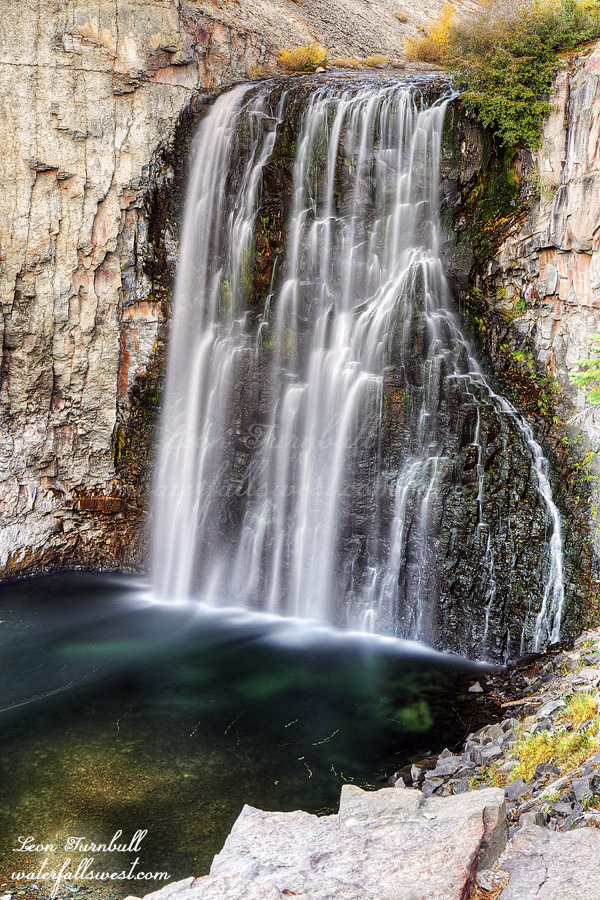
I knew I could not camp at the upper falls (shown here) – at least not anywhere with access to water, so I went down to the lower falls to camp. I thought there would be plenty of spots to setup my tent but there really wasn’t very much. The ground was too soft to put tent stakes in and it was quite windy which was pulling the stakes out of the ground. I piled some big rocks on top of the stakes and hoped my tent would stay in place. If it got too windy, I might be blown all the way to Kansas during the night.
After dinner I went back up to the 101 ft. high Rainbow Falls to take photos. That is when I noticed a sign that said there was toxic algae in the water. Oh bloody great. I already drank the water down at the lower falls! Was there toxic algae down there as well? There weren’t any signs but it is not very far from the upper falls. If there was then I was already dead. But I got my water out of a good flowing part of the river. That should be ok. Right? Well, if you are reading this then I guess you know the answer.
I went down to the bottom and found the waterfall still in the sun so I sat down and waited. There was quite a bit of garbage around. If you are the one who left your dirty diaper down here for me to take back for you then please send me your address so I can mail it to you. I’m sure you did not mean to leave it there. (insert mad face emoji here). As I waited, a chipmunk came by, hoping for a snack. He became disappointed and left. Surprisingly, I had cell service so I texted with my wife while waiting for the sun to go down. I did not have to wait too long. I took my photos then went back to camp and watched a movie before going to bed. In the morning, everything went to berserk …
Posted in Eastern Sierra, Waterfalls by leapin26: October 23, 2022
My next mistake: I thought I could get down to the bottom of the main Lake Catherine Falls on the west side of the creek. I did have the proper route mapped out on my GPS but I did not have enough time to climb around and down on the other side of the creek. It took far too long to get to this point and the sun was about to come out over the mountains. From the upper falls it looked to me that it would be possible to get down on this side of the creek and it would be much faster. It also seemed that Sierra High Route hikers had gone down this way so it must be possible. Yeah … Not true. I got down to the top of the waterfall and was cliffed out. There was no possible way down. Now I definitely had no time to go all the way back up and around. Thankfully there was a very good view of the waterfall from the cliffs. Whew. That was a bit lucky. I definitely should not have come down this way but it just took too darn long to hike from Thousand Island Lake. If I had planned to camp three nights instead of two nights I would have had plenty of time to do all I wanted here. At least I got to see three nice waterfalls this morning (the third one was a small 20 footer but quite nice).
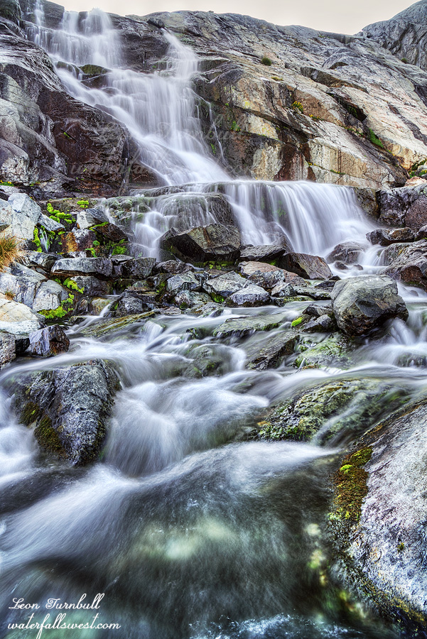
Lake Catherine Falls is a stunning 65 ft. waterfall dropping off a cliff into a lovely little tarn with a magnificent mountain backdrop. From the cliff side it is a spectacular sight. I took my time enjoying the view and eating my breakfast after taking all my photos.
Now that I was done with the waterfalls I wanted to spend some time exploring this basin. I had all day. I went over to see the Ritter Lakes and then back to Lake Catherine where I sat beside the lake for a long time enjoying the view of the glacier and lake. And resting. I was very tired from the morning hike. It was so tough! (did I already say that?) A couple Sierra High Route hikers came up from Thousand Island Lake and we chatted briefly. I was surprised to see anyone in this remote area.
In the past three years it seems that the glacier has retreated significantly. I saw some photos from 3 years ago showing the glacier going down right into the lake. Now it is retreated back from the lake. Climate change, right? I find it interesting that some folks get so antsy about the glaciers melting (it’s the end of the world). Well I can somewhat understand it because glaciers are so incredibly magnificent. It would certainly be a horrendous shame if they all disappeared. But on the other hand I say to them: get over it. The world’s climate is always continually changing. If the glaciers were not melting then guess what: Lake Catherine would not exist (and these waterfalls would not exist either). This entire basin was covered by glacier in the past. Because the glaciers have been melting since the ice age 4000 or so years ago we now have this incredibly beautiful lake and beautiful waterfalls. You can’t have it both ways. If you want the beautiful lakes and waterfalls then you can’t have glaciers not melting as well. In the future the waterfalls here will not exist either. All the more reason to get out there and see them now while they are still here. Don’t miss out on seeing such a beautiful part of the creation. That’s my philosophy. I missed seeing Coquette Falls on Mt. Shasta when it existed and now that the glacier above it is retreated too much, no one will see it ever again.
After enjoying the beautiful Lake Catherine I returned to my campsite back at Thousand Island Lake. I rested all afternoon trying to recover from my tough day of hiking. The wind kicked up in the afternoon. It was a very cold wind. Sitting in the shade was too cold and in the sun it was too hot. At night, the wind stopped for a short while but then it picked up again in the middle of the night with a vengeance. It was shaking my tent around all night long and it did not stop. Nonetheless, I still had a very good sleep despite the crazy wind. All the next day it was very windy. The wind was good in the sense that it kept all the smoke away from the area but bad news for all the fires in California.
I was up at 5AM in the dark. Very early. While I was eating my breakfast in the dark, I had some visitors. A couple mice came up to me looking for a handout. They were not afraid of me at all, but they sure did freak me out. While I was fending off the critters, I noticed the other hiker camped near me was already up and packed and started hiking back. Who is crazy enough besides me to hike in the dark! I had a long hike back and I needed to get back home because we had a concert to go to in the evening. My wife would not be happy if I did not make it back in time. I finished my hike just a bit past 11AM and made it home before we had to leave for the concert. It was a fantastic trip into the Ansel Adams Wilderness.
Posted in Eastern Sierra, Waterfalls by leapin26: August 25, 2021
This hike has been on my list for a couple years but I was not planning to do it this year. One word: FIRES. I was initially planning to go to Mt. Shasta this month (August) but that is clearly out of the equation now due to the fires up north. The reason I wanted to go to Shasta is because the waterfalls there are glacier fed waterfalls and so they flow in the summer. There is pretty much nothing else flowing now in California because of the drought. But wait! The waterfalls at Lake Catherine in the Ansel Adams Wilderness are also glacier fed. I know they are flowing because I saw some recent pictures from someone that was just there. I have not been to them before. There are no fires there. Perhaps I should go now. And so I shall!
I was surprised there were permits still available for this location because it is a popular place. Not Lake Catherine, but Thousand Island Lake is extremely popular and it is in the same permit area. I took advantage and snagged a permit. I decided to start from Rush Creek mainly because I have not done that trail before. It is more difficult (1000 ft. more elevation) but I figured I could handle it. I have not hiked at all in two full months (since the High Sierra Trail in early June) but I have been working out every day. Long story short: I totally underestimated how difficult this hike would be. That was my first mistake.
It is 3000 ft. elevation gain from June Lake up to Thousand Island Lake and then an additional 1500 ft. to Lake Catherine. That’s 4500 ft. elevation gain! I took my heavier tent because I knew it was very rocky at Lake Catherine and I knew of only one very small campsite there. The Z packs would not do well in such a spot. Well, that was my second mistake. I could have planned this entire trip just a bit better. The Z packs would have been fine.
The permit office did not open until 8:30am and I was first in line. I got my permit and started my hike by 9:30am. Not too bad. It is a relentless climb. I arrived at Thousand Island Lake at 3:30pm. I was beaten. Honestly, there was no possibility of getting to Lake Catherine today. I was so tired. Plan change. I hiked to the far end of Thousand Island Lake and found a campsite. 99% percent of people camp at the near end of Thousand Island Lake. Who wants to hike all the way to the end? No one does. That means I had the area all to myself. Well, almost. There was one other person there but he was not too close to me. It was a bit strange where he camped. He was a long way from the lake and basically had to walk a full quarter mile just to get water from the lake. Why would you want to camp so far from water when you don’t have to?
My new plan was to stay at this spot at Thousand Island Lake for two nights. I would do a day hike to Lake Catherine the next morning. That meant I had to get up and start hiking in the dark if I wanted to get to all the waterfalls before the sun. Once again, I totally underestimated the hike. It starts out quite nice and although it was dark it was easy going and I even found a trail. Then … we come to the boulder field … The trail disappears. The terrain becomes much steeper up to North Glacier Pass. Basically you have to climb straight up the boulders to the top of the pass. It is difficult. It is dangerous. It is slow going. Just when I thought I was at the top I find out it is a false summit. There is still another 100 ft. of boulder climbing to go. Holy macaroni that sucketh. It is now getting late and I realize there is no possible way I will get to all the waterfalls; nonetheless, I can still get to some of them. I finally arrive at the summit and get my view of Lake Catherine dwarfed below Banner Peak and Mt. Ritter, with Lake Catherine Glacier sandwiched in between. I was expecting a lot from this viewpoint and it did not disappoint. Lake Catherine is most definitely one of the most beautiful lakes I have encountered. The color of the lake from the glacier water is stunning, especially once the sun comes out. The scene is magnificent. I could sit here all day but time was running out and I had waterfalls to see.
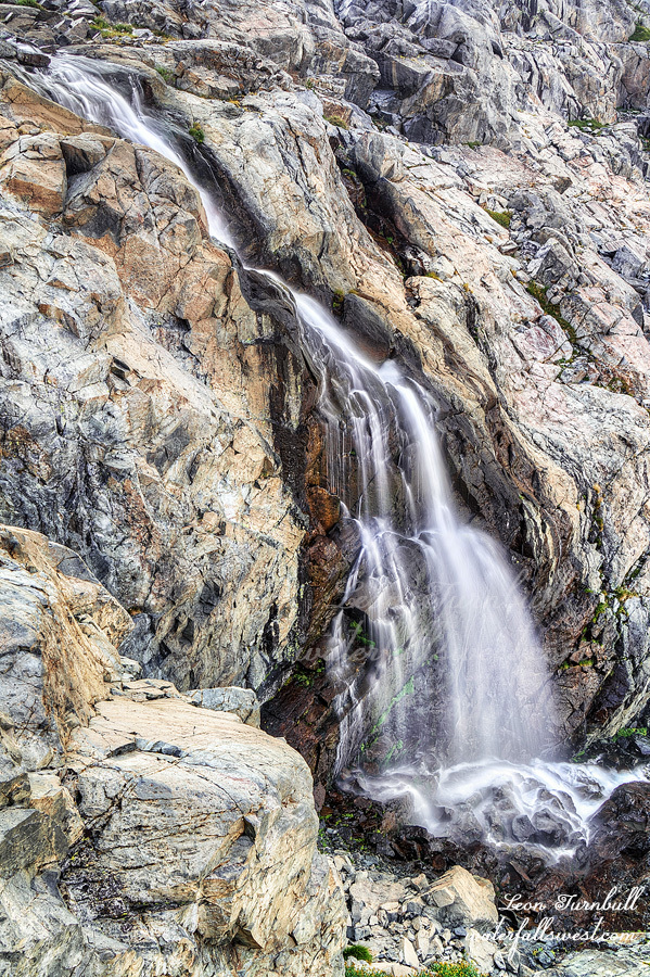
The terrain on the other side of the pass is no easier. It is a 200 ft. descent down to the lakeside and then another wild boulder scramble along the lake to the end. From what I could see the glacier was not melting. Would the waterfalls even be flowing anymore? I was a bit concerned. However, when I got to the outlet stream my worries were alleviated. There was still plenty of water in the creek. Even though the glacier may not be melting at the moment it must have been melting enough when the temperatures were hotter a few weeks ago. I made it down to the first waterfall, Upper Lake Catherine Falls, a very gorgeous 40 ft. drop. What a stunning sight to come and see in this drought stricken summer in California.
I still had a couple other waterfalls to see and time was running out. Stay tuned …
Posted in Eastern Sierra, Waterfalls by leapin26: August 22, 2021
I got up in the dark. I got up too early. I totally overestimated how long it would take to hike up to the upper falls. Indeed, it was a pretty short hike. I had calculated that the falls would be in the sun immediately after sunrise, so I wanted to be there at sunrise and no later. But it was not sunrise yet!
When I arrived at the upper falls, it was still dark. I had about 30-45 minutes to wait for sunrise. I could have slept so much longer! Well, I filled up on water and I ate my breakfast. That took about 15 minutes, I suppose. It was quite a bit cold, waiting around with nothing much to do.
Finally, the light came and I was able to take some photos of the waterfall. I had hoped this waterfall would be a bit nicer, but the flow was low. Certainly, it would be spectacular in the spring. Well, it was still quite a bit pretty, even on this day.
I got back to camp, packed up and made some coffee. Then I hiked back down the mountain. I don’t know why because the trail is only about 6 miles, but it took a long time to hike down. (as it did to hike up). Why is that? I was hiking fast (not running or anything, but not going slow either). It just seemed to take so much longer to hike this trail. Made no sense.
Anyhow, I got into Mammoth Lakes, and I found that the power was on. Hallelujah! I stopped at John’s Pizza Works for lunch (as I always do). Then I made the long drive home.
Posted in Eastern Sierra, Waterfalls by leapin26: October 11, 2019
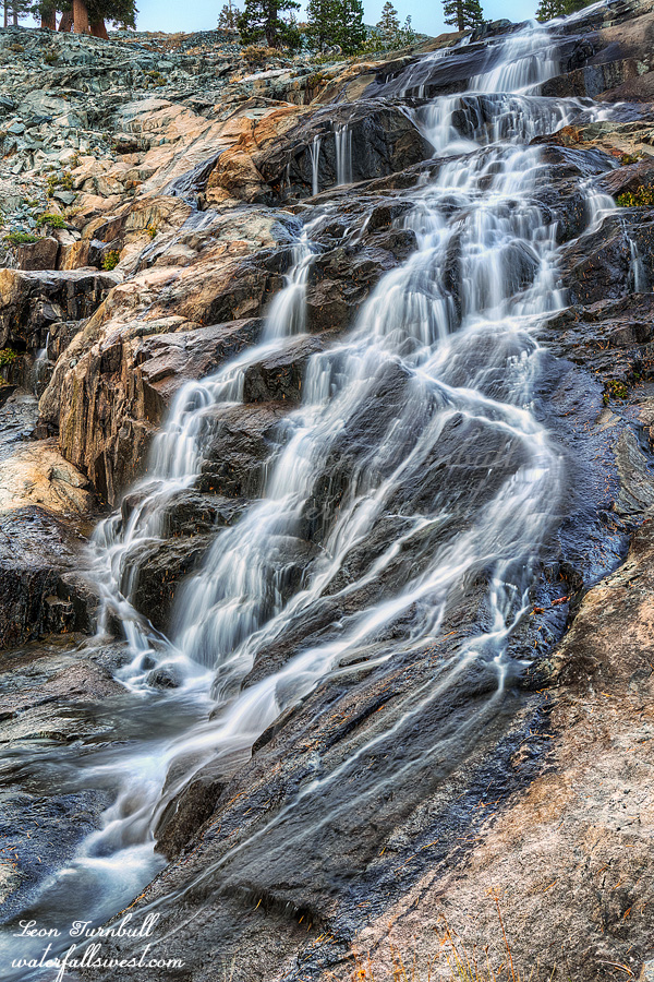
I went straight to the top of the middle falls after photographing lower King Creek Falls (previous post). Then I worked my way back down the creek, photographing along the way. I would love to return here at high flows. Perhaps some day I will.
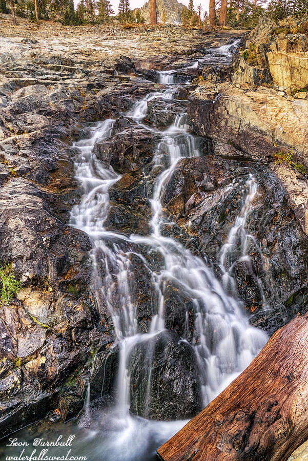
Middle King Creek Falls is essentially one big 200 ft. high cascade. It consists of four separate sections with steeper and significant drops. All four of these sections would be fantastic at high flows. At low flow, I thought the lowest of these sections was the most intriguing (pictured here). It is about a 50 ft. drop and very pretty.
I got back to camp a little before dark, and got ready for bed. It was only 6:30PM. Too early to go to sleep, but I was very tired. Nonetheless, I did not sleep all that well, but not horrible either. On the plus side, it was not as cold as I anticipated it would be. When I drove to Mammoth Lakes the previous morning, it was extremely cold (below freezing). Since I would be camping at a much higher elevation, I anticipated it would be below freezing at night. The forecast said it would only be 37-40 degrees, however. Either way, I was prepared, but what would it be? I was expecting the worst. However, it was not that cold at all, maybe not even down to 40 degrees, but it was around that temperature. I was toasty warm in my sleeping bag all night long.
Posted in Eastern Sierra, Waterfalls by leapin26: October 10, 2019
