TOUCHDOWN!
The sun is out. It is time for backpacking! Let’s go to Big Sur!

The sun is out. It is time for backpacking! Let’s go to Big Sur!
Over the past 3 months and a bit I have worked very hard. I lost 20 pounds in weight during that time. It took a lot of discipline, exercising 6 days a week, and not eating any extra snacks/desserts at all (except for 1 day per week when I allowed myself to eat anything I wanted). It worked! Mission Complete. Now I am back at my ideal weight, I feel in great shape, and I am ready for backpacking season! Except that it is winter and we still need a lot more snow! As of Feb. 1 the snowpack in California is at 170% of normal (north), 209% (central) and 252% (south). Rain is at 136% (north), 173% (central), 169% (south). This is good of course but we are still in a drought and we still have 2 months of winter left. A lot more is needed to end the drought. In fact, to be honest, we really need about four good winters in a row to get back to normal in CA. Not sure that will ever happen but let’s just take it one year at a time.
Anyway, it was time to celebrate! And gain all that weight back in one single weekend. Ha ha! It was my wife’s and my birthday and we decided to go to Monterey for the weekend. The ocean is my wife’s favorite place to be. I did not have much on the agenda for myself (ie. waterfalls), except for Saturday morning I said I wanted to go see a couple falls. There really wasn’t much in the Big Sur area that was open (everything is still closed from the storms), so I thought we should go north instead to the Santa Cruz area. I wanted to go to three waterfalls and we had very little time because it was supposed to be sunny and all these falls get early sun. I had 30 minutes to get to the three of them. Thankfully they were all very close to each other, but unfortunately I only made it to two and it was not because of the sun.
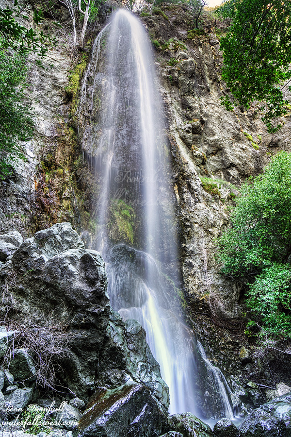
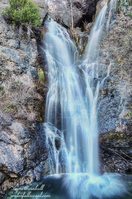
Elliot Creek Falls was the best one of the two, a very gorgeous 56 ft. high waterfall along the beach. It was easy getting down to the beach and it was very beautiful and we were the only ones there at sunrise. Except for a dead sea lion. Eck.
I should have made it to the third waterfall. The tide was well on the way out. I thought it would be easy. It should have been easy. However, the waves were still crashing up against the cliffs. There was no way to get past them and to the waterfall. It was a bit disappointing but nothing I could do. Well, it was a very lovely weekend in the Monterey and Santa Cruz area and my wife was happy.
I did not think I would be going out hiking to any waterfalls this weekend. The plan was for the family to go to Monterey for the weekend in celebration of my daughter Nekoda’s 13th birthday. THIRTEEN !! Now I have TWO TEENAGERS! I don’t believe it. It was her desire to go to the beach, shop around in Monterey, relax, have fun, etc. My son Jadon also had a birthday this month, and he also wanted to go to the coast. Of course, my wife always wants to go to the coast. So hiking to waterfalls was not going to be happening this weekend, which was perfectly fine.
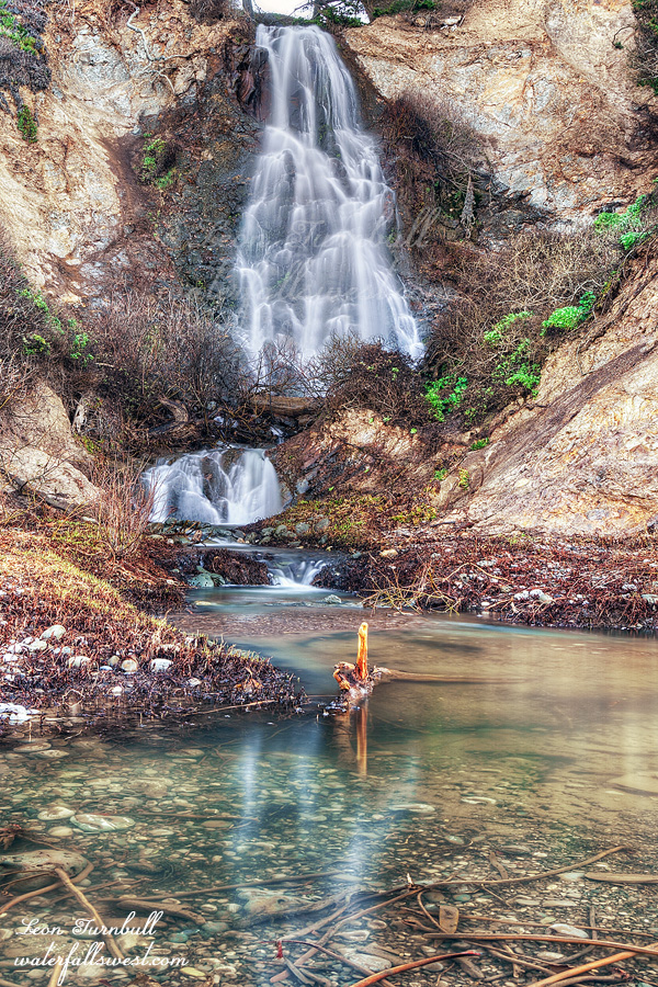
HOWEVER, I put out into the air to the family the suggestion of going on this hike to this waterfall. It was a nice little waterfall close by, and not too hard of a hike. I was not expecting any good response from them. Tara and Jadon did not want to go, but I ended up having a big ally in Nekoda. Once she saw some other people’s photos of the waterfall, she really really really wanted to go on this hike. Why? Was it because it was such an awesome and spectacular waterfall? (which would have been daddy’s preferable response) No! No! No! It was because of the big log in front of the falls. She wanted to climb out on it! And of course, she wanted to take selfie photos and post them on Instagram. Teenagers! She was not technically a teenager yet, but in essence she has been one for at least a year now. Mom said no way, too dangerous, and I was on the fence about it, but if it did not seem too dangerous when we got there, then I said she could do it, just so long as I could go to a new waterfall and leave early enough so I could photograph it in good light. Hey let’s do it people!
Getting the family up early enough was a huge challenge, and it was a bit late by the time we got on the trail. I calculated that we needed to be at the falls by 9:30AM, and we would not make it. We would have to start jogging. Tara and Jadon stayed back for a slow, leisurely pace. Nekoda and I ran ahead. There were a couple trail junctions along the way. We left arrows for Tara and Jadon, and I hoped they would see them and go the right way. We also left some trail magic along the trail for them (my water bottle), to help urge them along the hike. About 3/4 of the way there, Nekoda’s hiking boot broke apart. The sole of the boot came off, so she was basically hiking with no bottom to the boot. That is not easy on the feet! She wanted to keep on going. She was determined to climb up on that log. When she gets something in her head that she wants to do, nothing can stop her (which is one of the many things I love about her). The last couple miles of the hike involved many stream crossings. With the lack of rain it was easy to rock hop. The creek was not flowing too well, but at least it was not completely dry. We arrived at the falls precisely at 9:30AM. Perfect timing.
I took my photos of the waterfall, then examined the log. The log is not really totally secure and it was bouncy. I don’t know how long it has been there (I don’t think it has been there very many years, actually), but sooner or later it is going to fall. If someone is on it when that happens, they will be in a world of pain. But anyway, that did not happen today and it seemed safe enough for now. I let Nekoda go out. She basically had to scoot on her butt up the log towards the waterfall. I took some photos (for her Instagram, and for me as well), and some video of her going out on it. It was fun for her, and she was a happy camper.
We waited almost an hour for Tara and Jadon to show up. They never did, so we headed back down the trail. We saw one couple coming up the trail to the falls. They had not seen them. This was odd. They never picked up the trail magic. Did they make a wrong turn? We finally saw a sign they had left on the trail further back. It said “cat” with a smiley face and an arrow pointing back to the trailhead. That was certainly a sign left by Jadon. They got to within 1.5 miles of the waterfall, then turned back. Ugh. We found them back at the car, waiting, and cold. We saw a ton of other people on the trails on the way back, but only that one couple going to the waterfall. The parking lot was completely full. Nekoda’s foot really started hurting in the last half mile of the hike, but she made it. We drove back to Monterey, had lunch at Bubba Gumps, went to the beach again, then drove home. It was a good day on the California coast.
2 Comments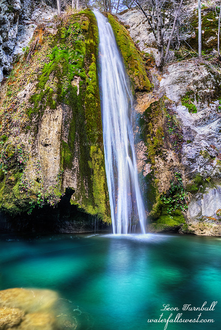
I only made it to one out of four waterfalls, but at least I was not shut out. Here is what happened. It is a long story but I hope you stay with me:
This was a four day backpacking trip into the Ventana Wilderness. I was waiting for a SHORT break in the weather and after SOME rain before doing this trip. Unfortunately on two counts: “some” rain was not enough on the Central Coast, and the “short” break has now become an awful much too long break. The February 1 stats are in: Rain fall in California is 68% of average (northern CA), 43% (central), and 30% (south). Snow pack is 27% of average (north), 30% (central), and 25% (south). The current dry period currently has no end in sight. It is so awful and upsetting.
Anyway … it was the morning of the lunar eclipse when I started driving down I-5 to towards the Central Coast. I did not plan this, but it just turned out this way. Every photographer in California I am sure was out somewhere photographing the event, a few of them came away with some great images. As for me, I did not bring my big camera and big lens with me. I never take those lugs on a backpacking trip and I was not going to leave that expensive equipment in the car for four days while I was out in the wilderness. I did not feel like I could get a good photo of the moon with my backpacking camera, nonetheless I did stop at the rest area on I-5 and took some video footage during the totality of the eclipse. It was not the place I wanted to stop to do this, but I was a bit late getting out of bed, and this turned out to be the only good place to stop.
Continuing on … I arrived at the trailhead at about 9AM and started my hike up into the wilderness. I would be gaining 2300 ft. in elevation on the first day (more, it turned out). So the big problem with this hike? Poison oak and ticks. The poison oak was mostly avoidable and I took great care to not touch it, and I did not get any rash. The ticks, however, were a different story. There were a heckuva lot of them, all over the place. Normally, ticks like hanging off the light brown/tan colored grasses hanging onto the trail. You can see them. Well, up here, they also like hanging off the dark brown/green brushes as well. You cannot see them. They even liked going on the poison oak. So if you touch it, not only do you get an awful rash, but you also get lyme disease. Just lovely. On top of all this, you are constantly swatting the gnats away from your face. And … you have to avoid stepping on all the California Newts that are all over the trail and do not move away when you approach them. I almost stepped on one because I was more concerned about avoiding the bloody ticks, but fortunately I did not step on any. It was very taxing to swath a path with my hiking pole through the grasses to avoid getting any ticks on me, but despite my best effort, I still ended up with two tick bites. It was very stressful. Honestly, this would have been an awesome hike if there were only no ticks.
The good news is that once I got above 4000 feet, the ticks and the poison oak disappeared (and the newts). The bad news: the trail was incredibly overgrown with manzanita and other brush growing over the trail. It was a huge effort to hack my way through it. I ended up doing this section four times! (why? read on…) I made it to the top and rested. It was already past noon. Now I wanted to descend down into a canyon (off trail), but this turned out to be far worse and more difficult than I anticipated. It was also the worst brush I have ever encountered on any hike I have ever done. This was much much tougher than it should be. Also, I began to highly doubt that there was even any water down in the canyon. If I got down there, and there was no water, I would be dead. Literally. I decided (wisely, I think) to go back up to the trail. It took an extra long time because I ended up going back up a different way and I came to absolutely impenetrable brush. The worst ever. By far. I had to go back down, and then find the proper way to up. By the time I got back to the trail, I was spent, it was late in the day, and I was almost out of water. To continue on from here to the next campsite, it was still a very long hike, it would be more uphill, and I could not be sure there was even water there (there was, as it turned out, but only a small trickle, and it would not have been good). I decided (wisely, again, I think) to go back down the trail to the previous campsite. There was water there for sure and it was shorter, all downhill. Unfortunately, a long way downhill. Almost 2000 ft. I made it to camp an hour before dark, just enough time to setup camp and eat dinner.
The very tough thing about backpacking in winter is that it gets dark very early, at 5:30PM. That is too early to go to bed. However, I was extremely tired, and I ended up sleeping about 11 or 12 hours. I was certainly well rested by morning and recovered enough to try climbing up the mountain again. 2000 ft. back to the top of the ridge. This time I stayed all on trail.
So I have to say that this second effort was all worthwhile once I got to the top of the ridge. The views were OUTSTANDING! On one side, the mountains of the central coast were spectacular and beautiful and green. On the other side, I could see the ocean from up here. It was magnificent. It was glorious. It was emotional. It was calling out to me. When you see the ocean like this, you just want to abandon your plan and go straight to it. I could have done so. The trail sign in one direction said you could hike all the way to Big Sur. Believe me, I thought about changing my plan and doing this. However, I had no maps for this section of trail. How far was it? (a long way, probably) Would there be any water? (not likely) How would I get back? (probably, I wouldn’t). In the end, the waterfalls won out over the ocean. Incredibly, I had cell service up here. I took a photo of the ocean and sent it to my wife. She was not very amused, and she was very jealous (she loves the ocean).
Well on to my next campsite. All the trails up here seem to be (actually, are) longer than what my Topo map says they were. It took longer to hike than it should have taken. I got down to the campsite and the creek, and just had enough time to setup camp and eat my dinner. Then I had to go on my next hike, to the first waterfall. The way to get there is to wade straight up the creek. I was in the creek multiple times, crossing to one side, then the other side, straight through it, whatever seemed easiest to do. With the low flow in the creek, it was not difficult. It was a bit fun, but again, it took longer than expected. It did not seem that there would be any waterfalls on this creek. It was so flat. However, I finally came around a corner and there it was. Beautiful! The water and pool was a glorious green color. There was an undercut behind the falls, you could probably swim under (in the summer). It was a very unique looking falls. The entire trip was “almost” worth it, just to see this glorious waterfall, and it is about 50 ft. high. Yet, this was not the main waterfall I wanted to see on this trip. I returned to camp just before dark. Again, I was incredibly tired, and I slept very well.
The next morning my goal was to see two other waterfalls on this same creek. This time I hiked along the creek downstream from camp. Before too long, the water disappeared. The creek was completely and totally dry. This was very unexpected. The water in the creek bed all went underground. I continued on down the dry creek bed for a long while, hoping beyond hope that the water would return to the surface. However, it soon became very apparent that this was not going to happen. The waterfalls downstream were bone dry. Well this was a huge bummer. Stupid dry winter! There was nothing to do except return to camp. Since it was still fairly early, I decided to pack up camp, and head back up the trail. No sense staying another night at this campsite. I made it back to the same place I stayed at the first night. I was tired and even though I was only 3 miles from my car I decided to stay one more night out here and make the easy hike in the morning. The last 3 miles would be very tick infested and I was far too tired to do battle with them on this day. I know I would have lost the battle tremendously. In the morning, I could deal with them. I fell asleep listening to the owls hooting to each other somewhere out in the dark.
P.S. This waterfall will be up on my website very shortly:
http://waterfallswest.com/waterfall.php?id=sugar-falls-2174
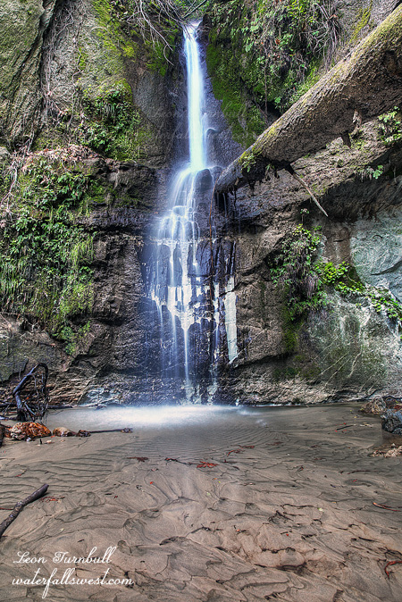
It is a very long drive down from Monterey to Salmon Creek Falls. I have been down there a few times now, and it always takes much longer than I think it will. You would think I’d have learned by now. I have to say I hate that highway. All the twists and turns just drive me psycho by the end of the day. It is a beautiful drive I suppose. Mostly though I wouldn’t know about that because I have my eyes on the road all the time, going bonkers. Ah well.
I was not planning to go to this waterfall, actually. I wanted to go to a couple waterfalls upstream from this one. Yes there is indeed an Upper Salmon Creek Falls. However things did not turn out as planned of course. Firstly, Tara’s knee was on the fritz again from the hike the previous day. I wanted her to come with me on this hike, but she could not. She insisted it was ok for her to wait in the car while I hiked. I hesitated. But she insisted again. And again. Well, ok then … I started up the trail but I did not get very far. The trail seemed to be going in completely the wrong direction from my map, up and far away from the creek. This could not possibly be the right way! I went back and tried a different route, going up beside the top of the lower falls, however that route eventually just fizzled out and it got too difficult to continue. Well I did not feel right about going on a very long hike anyway so I just went back and photographed this lower falls again. As I found out later, the first route was the correct one after all, but my map was wrong. It was completely my fault. Ugh. I will know better next time! If I can brave that crazy drive one more time, that is.
Since we were all the way down the coast we continued further down to Hearst Castle, a place I had never been to before. It definitely was a very interesting place, and I do recommend going if you have not been there. It was an extremely hot day; it is supposed to be winter, but it felt like summer. It was totally nuts. Up at the castle, however (1000 ft. higher in elevation), it was very chilly (and of course I left my jacket back in the car, brilliant!). I was hoping to see one of the zebras that run freely on their land, but instead we saw some of the very interesting aoudads (barbary sheep). The dumb bus driver only stopped for a grand total of three seconds to let us see them (and try to photograph them in that time). Geez is it really that important to keep to your stupid timing schedule so Alex Trebec doesn’t get off track on your useless voice audio (if you have been there, you know what I am talking about). I did get a somewhat ok kinda crappy photo of one of them in those three seconds. If you would like to see it click here.