Upper Sheep

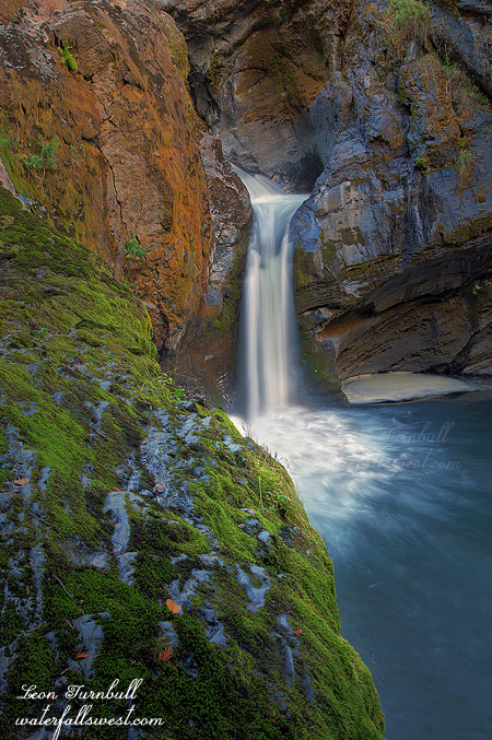
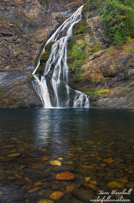
This is Upper Sheep Creek Falls in Northport Washington, 21 ft. high. It is tucked in a pretty little gorge, and certainly a very interesting little waterfall.

It is an easy hike up from the lower falls to the upper falls, but it was a bit too far for Nekoda to walk (though actually, she could have done it easily, I think). I tried to entice Jadon to come with me but he just did not want to come, and instead all 3 of them stayed back at the car, and I just took the dog, Kaya, with me. At the end of the road, I knew I was right beside the waterfall, but I could not see it. It was a very steep drop down to the creek, and I wondered how I could ever get down there. There was a path over to the edge, so I followed it, but it took me right to the cliff above the waterfall, and no descent was possible there. There was an old mining structure which looked rather unstable to walk upon, no dice. I could not even get a view of the falls. I retreated. It was Kaya who found the “proper” trail down on the way back, I would have missed it completely if not for her. She is such a smart dog. But also a strange one. She was whipping down the trail like nobody’s business, then she came to one spot which was particularly tricky (or so she determined), and she would not would not continue. I could not entice her down this one spot no matter what. So instead, I went back up to her, and found a different way down (which I thought was much worse), and she had no problems going down this different, steeper, route. Silly dog. We got to the bottom, but could not get all the way down to creek level. There was a ledge you could walk out close beside the waterfall, but it was slippery and I did not want Kaya to wander around too close to the edge while I was talking photos (she has almost fallen over waterfalls in the past), so I tied her up for my own peace of mind, while I took some photos of this little gem.

No Comments

Sheep Creek

On the way up to Rossland, we stopped off at Northport, WA. I’ve been meaning to try to get to this certain waterfall on Sheep Creek. It is on private property and there is a powerhouse right beside it, but the owner allows people to come here. I previously was not sure exactly how to get here, but Gregory Plumb (Waterfall Lovers Guide to the Pacific Northwest) provided me with fresh off the press directions and I was eager to try them out. His directions were pretty good, but I did miss the turnoff from the highway, as there is no indication you are on the right road (except for no trespassing signs). But I knew it was ok to trespass here from others who have told me. There was no one around anyway.

It is a fairly easy descent down to the base of the falls, and the whole family made the journey. We had an enjoyable time down at the falls, playing in the water. Jadon of course had to try out his new rain boots, and went splashing across the creek, but it was deeper than he thought, however. I measured the waterfall as being 149 ft. high, but it sure did not seem that high. It seemed more like 80 ft. or so to my wife and I both, but I will stick with the official measurement of 149 ft.

This was one of three waterfalls I went to on my vacation. I had planned to go to more. I even went on additional hikes. In Rossland, I was really hoping to find one particular waterfall, but unfortunately, I did not have good directions, or good hiking maps, and I did not know exactly where it was, though I had a vague idea. By looking at the map I did have, I estimated the hike down to it would be 12 miles round trip, 14 tops. That is well within my hiking range, so I decided to give it a go. Well, it was not 12 miles. It turned out to be 20 miles, and the worst part was the descent. You need to climb up a mountain, and then down the other side all the way down to the bottom. I had no idea before I started as to the topography of the area, but the trail just kept going down, and down, and down. By the time I got to the bottom, I had descended 2800 ft. And there was no waterfall in sight. By this time, I knew I was well past my hiking limit. I was not even sure I could get back up the mountain. I should never have gone down in the first place, but I just kept thinking the waterfall was not too much farther, and how much farther could I descend anyway? I had to turn around before I got to the waterfall, though I think now that I did not really need to go too much farther to get to it, but as I said, I was well past my hiking limit, and I could not have gone any further. 2800 ft. is definitely a long way up. I took it slowly, one step at a time, and eventually I made it. I did not really have too much trouble on the ascent, the worst part were the blisters on my feet, making it very painful to walk, especially the last few miles. I estimated the total elevation gain for me on this 20 mile hike (with all the ups and downs) was about 4300 ft, making it one of the worst hikes I have ever done (for elevation gain). But the good part was the entire hike was at low elevation, so this is why I was able to do it. On one of my recent hikes at Lake Tahoe, I had a lot more difficulty even though the distance and elevation gain was much less, and that was due to the high elevation of that hike. Anyway, as it was, I barely made it back to Rossland by dinner time. Fortunately, my mom had her famous lasagna in the oven and ready to eat when I got back. Thanks mom. That sure helped me recover some energy, but I was essentially out of commission for a couple days after this hike, thanks to blisters and bruises on my feet. I definitely overdid it this time.

2 Comments