It is impossible to see Waterwheel Falls at peak flow. Never mind that Tioga Pass road is not open until well past the high flow for the year. If you go the way I did in early season you have one big issue: the crossing of Register Creek. It was my great desire to see Waterwheel Falls at the highest flow possible. But how high could I really see it? With the data I had I determined that 1000 cfs on the Tuolumne River was the highest I could reasonably and safely cross Register Creek. Any higher than this and the creek would be uncrossable. My initial plan was to wait until mid May to come here which would be past the peak flow (and safer). However, late season April storms changed this plan. Now I determined I should come earlier in the season (before the peak flow). This is a lot trickier for timing. I would not want to be caught on the wrong side of Register Creek when all of a sudden the snow melt explodes within a day or two (which it most certainly can do and has done before). I watched the weather and the flow very closely for weeks. I had a window and it was about to close. On Monday 5/2 the flow was at 980 cfs and rising. On Tuesday the weather was forecast to warm up significantly. This would cause the snow melt to shoot up significantly as well. If I could get to Waterwheel Falls by Monday and return back across Register Creek before noon on Tuesday I would be golden. My timing was impeccable.
I slept very well at my campsite beside Register Creek. None of the other days on the trip did I sleep well. Just this one night. Was it because I slept next to a roaring waterfall? I don’t know about that. Anyway, I woke early, packed, and then took a long look at the creek. I expected it to be down a bit from the previous night. It was most certainly *not* down. This was surprising. Snow melt always peaks during the late part of the day and during the night the flow is reduced when the temperatures cool down. Hmmm well … this should be a bit interesting. The crossing was actually not too bad. There was definitely a strong pull but it was safe enough; although if it was too much higher it would definitely have been uncrossable. I believe my estimate was pretty much spot on.
You may perhaps be wondering about all this planning that I did for this trip. Is it really necessary? It is absolutely necessary. You cannot just go out on a hike la di da and not know what the conditions are. It does not matter if it is creek crossings or snow or weather or whatever else. If you were to go on this hike and do the crossing of Register Creek and then come back 2 days later and find out you cannot cross it then what are you going to do? A lot of people would try crossing it anyway and that is exactly how people die. Anyway back to my story …
As the sun came up I found myself at the top of Muir Gorge looking across at Ten Lakes Falls and over the Tuolumne River with the snowy mountains in the background. It was a very spiritual moment for me. Such incredible beauty in God’s creation. I was truly at a loss for words.
I was not at a loss for words when I caught my first glance of Waterwheel Falls. The words out of my mouth actually were: HOLY CRAP! What an amazing sight to see, 314 ft. of sheer power. Waterwheel Falls was out of this world astounding. Holy awesome waterfall, Batman!
It was only noon when I arrived at my campsite at the base of Waterwheel Falls. It was a short day and I was able to get some much needed rest the entire afternoon. It was a gorgeous afternoon.
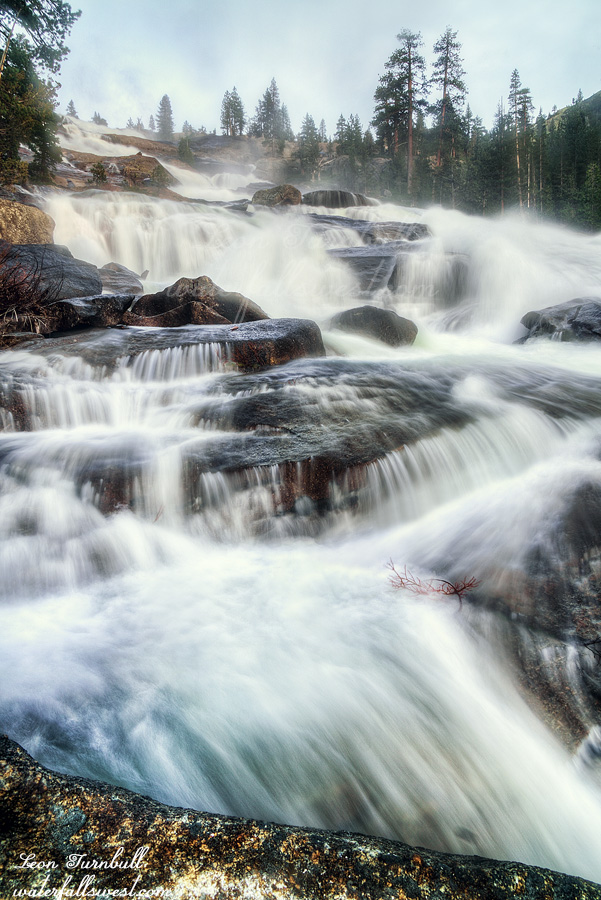
In the evening I climbed to the top of the waterfall. When I was here in late May 2012 (a drought year) Waterwheel Falls had much lower flow. At lower flows you cannot really notice the namesake “waterwheel” of this falls. I did not notice it anyway. Indeed nearby Le Conte Falls had a more significant waterwheel than Waterwheel Falls. This is one of the reasons why many people mistake Le Conte Falls for Waterwheel Falls. I very much wanted to see the real “waterwheel” of Waterwheel Falls. Standing at the brink of the 314 ft. falls at high flow, I found it indeed. It was spectacular. Now I had a tough choice to make. The waterfall is in the sun until the very end of the day. I could take a photo at sunset from the top of the falls or at the bottom of the falls. I could not do both. I decided that I would go back down to the bottom and photograph the falls from there at sunset. I made the wrong choice and I regret it. I’m really mad at myself about it. I should have stayed at the top for that iconic shot of the waterwheel. At the bottom it was just far too misty everywhere to get any kind of good photograph. Out of all the many shots I took I only got one decent photo (pictured here, obviously). It is probably a miracle that I even got one decent shot. (thanks Lord, whew). It is not a bad photo at all but it still would have been a much nicer shot from the top. Oh well, nothing I can do about it now. I could have stayed a second night at Waterwheel Falls and I probably would have, except then I’d surely be stuck on the wrong side of Register Creek. My window was closing rapidly and I had to leave the next day or I’d be in serious trouble. Time for bed.
Posted in Waterfalls, Yosemite by leapin26: May 12, 2022
I did not sleep too well at Harden Lake. It was not because of the frogs. It was not because of the cold either. Everything was frozen in the morning. Ice on my tent. Ice in my water bottle. Frost on the ground. I was not cold in my sleeping bag, however. In fact it did not feel very cold at all but obviously the temperature was down to freezing.
I packed up quickly and hiked down to Upper Morrison Creek Falls (previous post). There was some snow I had to traverse on the way down. It was not icy and I did not need my spikes. (so that is one pound of extra weight I did not need to bring – but who knows, it could have been a lot different and then I would have greatly regretted not bringing them).
Upper Morrison Creek Falls was not as nice a waterfall as I envisioned it being. I thought it would be cleaner and prettier. As I ate my breakfast I wondered how I was going to cross this creek a bit later. The creek was flowing pretty fast. There were some sections that were crossable and some clearly not crossable. What would it be like down where the trail crossed it?
The trail descends 3400 ft. from Harden Lake down to the Tuolumne River. That is 3400 ft. I would have to climb back up at the end of my trip. It is a steep steep descent. Essentially it is straight down and it took a lot longer than I anticipated but at least the Morrison Creek crossing was easy.
Finally I made it down to the Tuolumne River and the famous Pate Valley bridge. This bridge was out for a couple years making the river impossible to cross but the park service made it a high priority to repair it (thankfully). The Tuolumne River was stunning and absolutely massive. It was rushing down into Hetch Hetchy Reservoir at about 910 cfs this day (5/1) and would continue to rise as the temperature climbed upwards during the week and snow melt swelled. My hiking plan was coming to fruition perfectly. (more about this on Day 3)
I rested at the bridge, drinking up as much water as I could manage to take away from the San Franciscans. I am kidding (sort of). From here I still had 4.5 miles to hike and 900 ft. elevation gain to my destination for the night. It is an incredibly beautiful hike along the river. There were very few mosquitoes but the gnats were outrageous. I was expecting a lot more of the mosquito variety and less of the gnat variety. They were not quite as bad as Tehipite Valley but not far behind. Smartly I had my headnet with me on this trip and that saved me (I always bring it with me now). Also there were no bugs at any of my campsite locations (unlike Tehipite) and that by itself made the trip extremely more enjoyable.
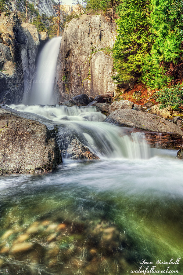
I arrived at Register Creek at 4PM, much later than I had hoped. There are a few waterfalls here but by far the prettiest is Lower Register Creek Falls (pictured here). It is a stunning 40 ft. drop immediately above the trail. This is where I would have to cross the creek in the morning if I was to continue up the trail. It was the one and only major creek crossing of my trip. The creek was flowing strong and the crossing looked sketchy and deadly. Would I be able to continue? Well that is something to worry about for tomorrow (Day 3).
For today I would camp here at Register Creek. There is one very small spot to setup my tent here and it was enough for me. It is a very gorgeous location. I enjoyed my evening, took photos of the waterfalls, and fell asleep to the roar of the waterfall.
Posted in Waterfalls, Yosemite by leapin26: May 11, 2022
The Grand Canyon of the Tuolumne River. Yosemite National Park. I have been to the main waterfalls on a day hike but I have always wanted to explore more of it. In peak spring season. Waterwheel Falls at peak flow. That was my dream. Starting at Tuolumne Meadows is a big NO. By the time Tioga Pass road opens the waterfalls are already at much reduced flow (whether it is a good winter or a bad winter, it does not matter). There is only one way in to the Tuolumne River in early season and spoiler alert: it is very difficult. (surprise surprise)
It should be a LOT easier than it is, frankly. We will come to that shortly.
I began the big journey at Hetch Hetchy Reservoir. I arrived at the gate 30 minutes before opening and there were already 6 cars ahead of me. Dang, I wanted to be first in line (like last year) so I could start my hike as early as humanly possible. It would be a very tough and long day. Well no big deal, the ranger even opened the gate 10 minutes early. I picked up my permit. They made me sit down with the ranger to talk about my itinerary. This tells you something about how difficult and crazy my planned route was going to be. But it was a good thing because I picked up a couple tips and adjusted my planned starting point which would make my hike a bit shorter and easier. (slightly easier).
I was planning six nights but I had food for seven nights (eight days) in case I wanted or needed to stay an extra night. My pack weight was 46 pounds with 11 pounds of food! I also had to carry extra warm clothes (it would be cold at night) and rain gear (there were showers in the forecast) and spikes (there was still snow). At least my pack should be a bit lighter on the return trip out of the canyon after I ate all that food.
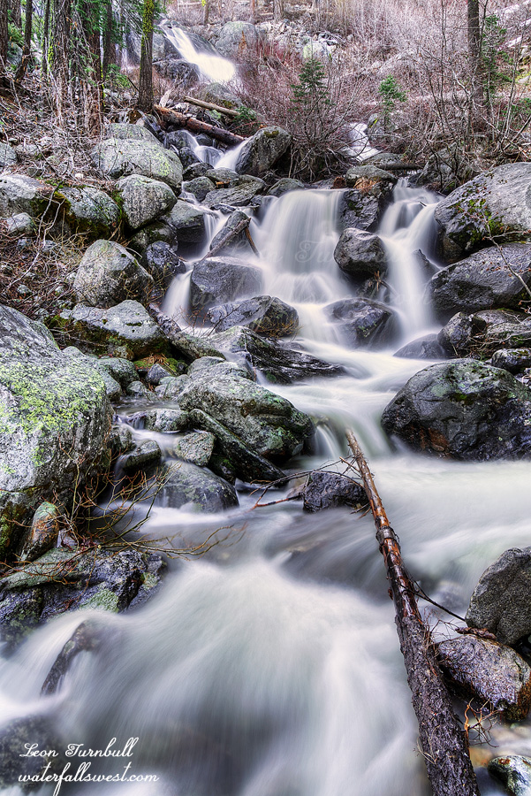
My first day would take me 11 miles to Harden Lake via Smith Meadows. A whopping 3700 ft. of elevation gain. If I could make it I had hopes to continue an additional 2 miles to Morrison Creek. Upper Morrison Creek Falls is pictured here.
It is a tough climb but the first section of trail to Smith Meadows is not too bad. There is some overgrowth and bushwhacking involved – which I did not know about beforehand – but I made it to the creek crossing in 3 hours. Not bad. My hopes were up. The ranger told me (and also I heard from others) that the section from here to Harden Lake is hopeless. The trail completely disappears. I knew it would be difficult but it started out pretty good and I was beginning to think they were all wrong. The trail was great. Then the fatal moment finally came: the trail completely disappeared in a wall of brush 10 feet high. I did not know which way to go. I seriously thought I was going to have to retreat back to the car. After quite a while of searching around I finally broke through the brush and found the trail again. I continued on. From here on until the top of the ridge it is a horrible bushwhack. The good news is that you can still follow the trail through the brush which is up to your waist or chest or higher. It took at least an hour or more of solid bushwhacking to reach the top of the ridge. Finally at the top, the last section of trail to Harden Lake is clear. How do you spell RELIEF?
Why is this trail so darn difficult? It is greatly upsetting to me. The trail should be clear. There was a fire many years ago and since then the brush has overgrown the entire area. But the park has not cleared the trail yet! This is a principal trail in Yosemite National Park and they have not bothered to do any maintenance on the trail whatsoever. They have let it go to rot. This trail is the ONLY way in to the Tuolumne River in early season. Why would they just abandon an established park trail? The ranger even told me that the trail crews were starting on the day I started my hike. Did I see any crews working on the trail when I returned some days later? Nada. I will tell you one thing: If I had $43 billion to spend like some people apparently do I would spend it on worthwhile things, and one of those things would be to clear every trail in every park and national forest in the country. This was the realization I came to as I battled my way along, unable to see the sunlight above me because the brush was so high over my head. Unfortunately I highly doubt I will ever have that kind of money to spend. Ha ha.
It took 7 hours in total to reach Harden Lake. I was done and much too tired to continue to Morrison Creek. I would spend my first night camping at Harden Lake and get up early to make it to Upper Morrison Creek Falls in the morning. Harden Lake was more like a pond then a lake. It does not have any inlet or outlet stream so it fills (I guess) entirely from snow melt. Even though we had a bad winter it is early season and I expected it to be much nicer than it was. It was also very difficult to retrieve drinkable water from the lake because it was so scummy all around the edge of the lake. Nonetheless I made do and found a nice place to setup camp and had a very lovely evening, falling asleep to the sounds of the frogs at Harden Lake. I love the sound of frogs and there were probably many hundreds of them at Harden Lake. They were amazingly loud. You gotta wonder what they talk about to each other non-stop all night long. They are such an amazing creation of God.
Posted in Waterfalls, Yosemite by leapin26: May 7, 2022
I slept fairly well in the car. The first time I’ve slept in the new Yeti. I got up at sunrise and prepared for the short hike down to the middle and lower falls of Patterson Creek (and one other one as well).
It is a little brushy but not “too difficult”. The biggest obstacle is the HUGE poison oak which is unavoidable. I was already going to get it bad so I may as well continue on the hike.
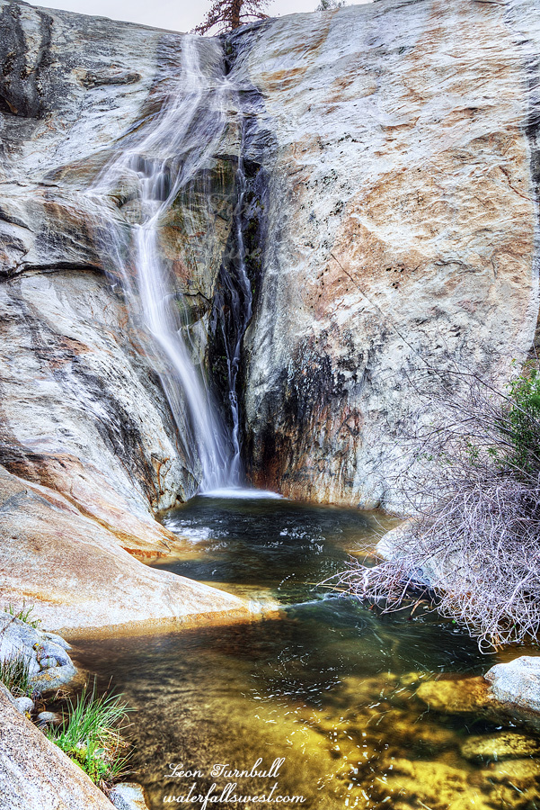
The lower falls is 306 ft. high and the middle falls is 121 ft. high. The middle falls is shown here. I liked both these waterfalls but again they would be much better at higher flows.
I returned to the car and then made the long drive home. I was so tired when I got home that I went to bed at 5:30PM and slept for 11 hours. I don’t know why I was so tired because I thought I had a decent sleep in the car but nonetheless I could not keep my eyes open past 5:30pm. That 11 hour sleep felt very good.
Posted in Southern Sierra, Waterfalls by leapin26: April 27, 2022
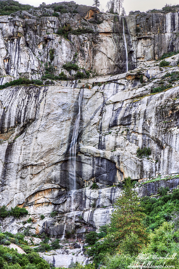
I was not planning to come here at all this year but a late season April storm messed up my plans. I guess I should say it just delayed my plans a bit because with 2-3 feet of new snow on the ground I would not be able to get to where I wanted to go this weekend. I decided to drive down to the Central Sierra for the weekend instead. The waterfalls here should be flowing very well, I determined, and I had not seen them before. Humph.
It is a five hour drive to Balch Camp and I arrived a bit before noon. I drove up to Patterson Creek Falls to check it out first. I would be returning in the morning to take photos but I just wanted to see it and also see if I could get down to the lower falls. I was very disappointed in the flow of the creek. It is a small drainage but with recent rain and snow melt it should be flowing a lot better than this. I was expecting a lot more. Sigh. I tried getting up closer to the waterfall but found it impossible due to very thick brush. A roadside photo is the best you can do here. Brush and poison oak were the major themes for the weekend (and perhaps, my life). The poison oak here is HUGE. In fact it was so big I did not even think it was poison oak at first. Poison oak does not get this big, does it? Ah well, tell that to my itchy body when I got back home.
I retreated back down the hill to Dinkey Creek. I wanted to backpack a short distance in to the creek and then hike up to a waterfall on Dinkey Creek. It was supposed to be a VERY EASY HIKE. There is a well defined trail on Google Earth. In fact it was supposed to be so easy and short (only a mile) I wondered if I should even do it. (I usually like hiking longer when I am backpacking).
The trail started out ok but it was already overgrown. The grasses were very long, above my knees. At least I could follow it (so far). Thankfully there were no ticks. It could have been disastrous if there were any of those buggers. Everything changed pretty quickly. The trail down to the creek was now completely overgrown with a huge amount of brush and deadfall. This is an easy hike? It was not even worth the effort to go down especially when I would have to hike this four times (I would have to come back up to continue to the waterfall). I decided to retreat and hike straight out to the waterfall and camp there. I was not very sure there would even be camping at the waterfall but maybe that trail would be better. Again, it was supposed to be a very easy and well defined trail. Again, it was completely overgrown and very difficult. How did this trail get so overgrown in such a short time? It makes no sense to me. I only made it half way to the waterfall and I was spent. I tried to continue but I was too tired. It was not getting any easier and if there was no place to camp ahead then I would be in trouble (plus, there was no way I could get to the other waterfalls in the morning if I had to hike back on this horrible trail). I decided I would retreat and just sleep in my car at Patterson Creek.
I slowly hiked back to the car and then drove up to Patterson Creek where I made my dinner on the rocks by the creek, and slept in the car.
Patterson Creek Falls is 925 ft. high in two tall tiers. It definitely needs to be seen very early in the spring. At least I got to one waterfall on this trip. Would I see more in the morning?
Posted in Southern Sierra, Waterfalls by leapin26: April 25, 2022


