It is November so it must be time for a backpacking trip. I don’t know why I said it like that. But seriously, the weather was looking really good this weekend (ie. not raining and warm) and I have been wanting to go out on another backpacking trip so why not go this weekend. Indeed. But where?
One of my all time favorite canyons is West Cherry Canyon in the Emigrant Wilderness. My precious. I have been there three times before and I had wanted to go a fourth time. You probably don’t remember but on my last trip I made it down to the lower falls, however I was too late and the light was awful so I did not take any photos (also, there was a naked guy camping there). Well I did not make it back in the spring this year so perhaps I could go in winter instead. The creek normally would not be flowing in winter but with the recent mega bomb cyclone I figured that it should actually be flowing decent. Unfortunately the gage is not functional at the moment so I had to take a wild guess on the flow based on other nearby rivers. My guess was 150 – 200 cfs. I would not want to go to this particular waterfall if it was less than 150 so I hoped my guess would be a good one.
I forgot how horrible the road to the trailhead is. Maybe it was my imagination but it seemed worse. The trail was definitely worse. A lot more downed trees blocking the trail than last time. It is not an official trail and is not maintained by the forest service so it is just going to continue getting worse and worse each year. Kinda sad because it is a great trail (not counting the overgrown sections) and it gets a fair amount of use. In fact, surprisingly, there had been another hiker here within the last week (since the last storm). There was a bit of snow at the trailhead (not much) and I followed his tracks for awhile. He seemed to be going down to the creek but exactly where I do not know.
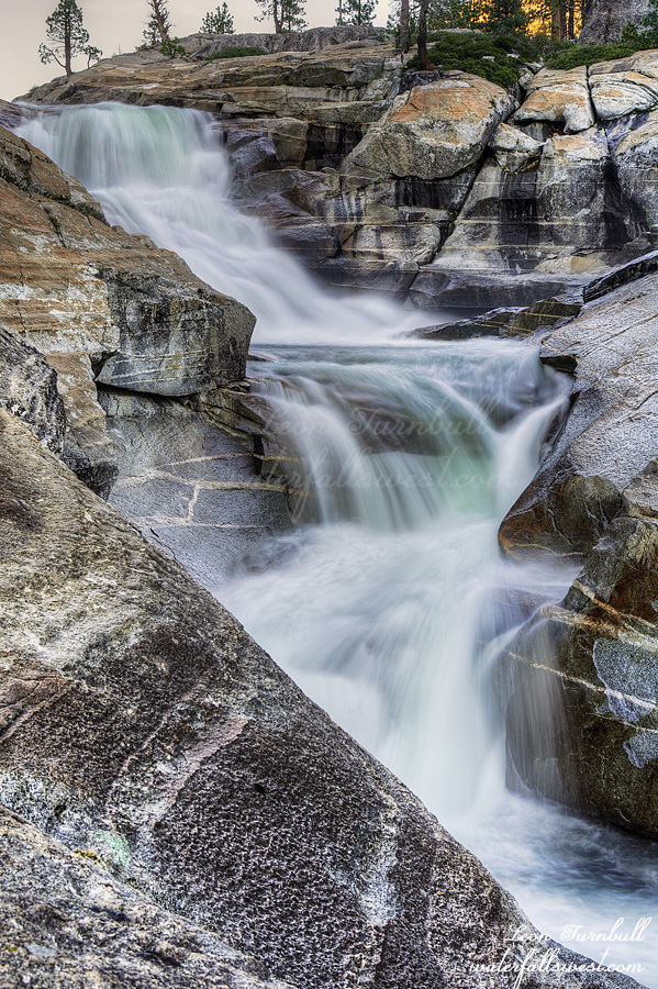
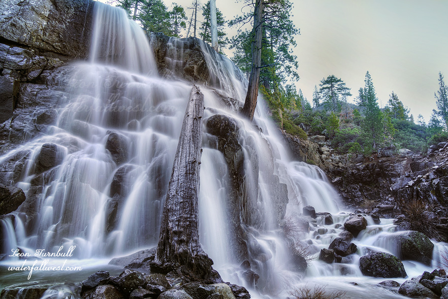
My route would take me down to West Cherry Creek and then further downstream, which required climbing up a ridge and down the other side. This part is difficult and is quite brushy and you need to weave in and around the brushy parts and the steep parts. It took a long time. I made it down to the campsite just past noon. This photo shown is *not* the waterfall where I camped. You need to wait for part two to see that one. Good news: there were no naked guys camping here. I had the place all to myself. More good news: the waterfall was flowing strong. I think my guess was spot on: 150 to 200 cfs.
I set up camp and ate my lunch and then relaxed in the warm sun in the afternoon. West Cherry Canyon is just so amazingly beautiful and I was so glad I could enjoy it to its fullest. At 3PM I went for a little hike. Other than the waterfall at my campsite there was one more waterfall I needed to see about a mile or so downstream. It was a lot harder to hike down river than I anticipated and it took a full hour to do it. That means I would not have enough time if I wanted to get back to camp before dark. I quickly took my photos of the waterfall (shown here) and then hiked back as fast as possible. I still wanted to photograph the falls at the campsite before dark but it was after sunset when I got back to camp. I took a couple quick shots of it (and more of it in the morning) and then I went to bed.
It was only 5PM! I can’t go to bed at 5PM! I got ready for bed, worked on my feet for awhile (blisters), and then I watched a movie. What would the next day behold? Stay tuned…
Posted in Northern Sierra, Waterfalls by leapin26: November 14, 2021
The first time I was here was in late 2014 at very low flow. I have always wanted to return when the waterfall is flowing decent. Now would be a good time, I thought. After 13 inches of rain it should be roaring, I thought. The Aftershock following the Bomb Cyclone last week.
It was not my first choice to go here this weekend. However, I only had time for a short easy hike because I had to get home to drive my daughter to dance class. Well as it turned out, she tells me at the last minute (after I get back home) that she is not going to dance today. Great. I could have done the other hike I really wanted to do. Thanks for not telling me, Nekoda. Teenagers. Sigh.
Well on the other hand, a short easy hike is about all I could do anyway. I put my back out in the morning before I left the house. I have to deal with the cats when my wife is not home and bending down to clean the litter is always an adventure with my back. Dang! The pain! Ugh! I should not go hiking, I thought. I must not go hiking, I thought. But I have to go hiking! It is the only day I can go hiking for a couple weeks and it just rained 13 inches! A short easy hike then. I can handle that. I hope.
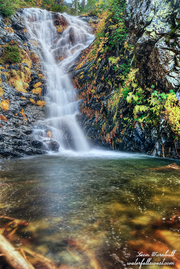
I could not quite drive all the way to the trailhead. There was a fallen log in the middle of the road (not from the recent storm). It added about 1.5 miles to the hike (round trip) so thankfully that was not too much additional walking for my aching back. Most of the hike is along a dirt road (easy), but the last half mile is off trail (hard) and involves traversing along a steep hillside trying to find a path through the manzanita brush, and then a final steep descent down to the waterfall.
Upper East Fork Falls is a gorgeous 34 ft. high cascade. It was certainly flowing well but it was not roaring. I thought the river would have a lot more water in it but nonetheless it was still fantastic. And very pretty too with the surrounding fall colors. It was a very lovely Fall hike in Tahoe National Forest and my back held up for it.
Posted in Northern Sierra, Waterfalls by leapin26: October 30, 2021
Seven years. A lot can happen in seven years. For instance, an unused road can become completely overgrown in seven years. For instance, a trail can become almost completely impassable in seven years. It has been seven years since I have been to this waterfall, and honestly, I think the last one to hike this trail was myself (not counting the bears).
It is the weekend of the bomb cyclone in northern California. That is apparently a real thing. All I know is that here in Norcal we are getting a huge storm. We had about two inches of rain on Friday and about 10 more inches are coming on Sunday. Thank the Lord! We need this rain so much. I ventured out on Saturday before the big one struck.
The road to this falls is impassable in the winter and after Sunday it will not be drive-able for certain. I thought that it would still be ok after just a couple inches of rain and it was definitely all right but there were still many puddles I had to drive through, a lot more than expected. Not only that, the road seemed much rougher than it was seven years ago.
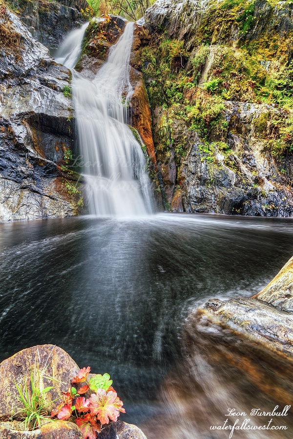
The last half mile of the road was completely overgrown with many downed trees. I have actually driven down this road in the past but that is impossible now. The actual trail down to the creek is even worse. Multiple blowdowns across the trail, more than I could possibly count. One section was completely blocked with trees down across the trail on a very steep slope. I had to figure out a way to climb up and around it (which I did, with difficulty). There was a lot of overgrowth on the trail, including poison oak. There was certainly a lot of bear activity but I saw no evidence that any human had been down here since I was last here. And then there are the ticks. It is October. It is not tick season yet but I saw quite a few of them along the trail. I was shocked. I considered turning back on multiple occasions as I trudged down the trail very slowly but I persevered and eventually came down to the creek.
Silver Falls is a gorgeous 41 ft. drop. I took many photos from many different vantage points. Hiking back up the mountain afterwards was not easy, a 1300 ft. climb out of the canyon, but I felt good and it almost seemed easier than going down. It was a very enjoyable hike before the bomb cyclone in Eldorado National Forest.
Posted in Northern Sierra, Waterfalls by leapin26: October 23, 2021
Hello, old friend. This is now the fourth time I have been to East Fork Falls.
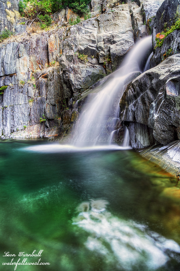
The last couple weekends I have struck out on my hikes. This weekend I needed a sure thing. Enter East Fork Falls. Why do I keep going back here? Well, I like it because this river flows year round. Even in horrible drought such as this year, the river still flows. It is a tough hike but a good one and a fun one, and the waterfall is pretty accessible (ie. not too crazy to get to). It is located in a stunning location, dropping into an incredible emerald green pool and towering cliffs all around. It is also close to home. I strongly considered going to the Eastern Sierra to see the fall colors but I just did not feel like driving so far. I decided to go to East Fork Falls at the last minute instead.
It is fantastic that we have rain already this year. It has been many years since we have had an early start to the season, and looking at the forecast it seems that by next week many of the winter waterfalls will already be flowing! It is only mid October! Praise the Lord for this, we surely needed it this year. Yet, we still have a weak La Nina this year, the exact same as last year, and despite the early start to the season I am still not feeling very optimistic for our winter this year. Maybe we will be surprised this year (like in 2011). I am praying hard for a good winter.
Anyhow, I was up at 4AM and was on the trail by 6AM in the dark. I hoped to get to the upper falls after the lower falls, so that is why I wanted the early start. I arrived down at the bridge over EFNFNFAR and thought: well, this is different. There was a brand new bridge over the river. Interesting. Not only that, but the old, incredibly overgrown road is now completely cleared. It confused me a bit, mostly because it was dark and I couldn’t see much but I knew this was not how it was last year. The good news is that this makes the hike a bit easier, but the bad news is that it means they are going to be clear cutting down here in the near future (probably next year, I imagine).
The road does not go all the way down to the river and the last section is still off trail and difficult. It seemed a lot brushier this year as well, especially near the river. I made it down to the river about sunrise. Now it is time to get in the water and wade up to the waterfall. As anticipated, the water was freezing cold so I brought my neoprene socks to keep my feet nice and toasty. They were not actually toasty but they were not freezing either. I also bought new hiking shoes and I must say that I really like them. My feet (as you may know) have been in much pain over the past 6 months or so. Even after resting for most of the summer they were still in pain when I went out backpacking in late summer. It occurred to me the problem may be my hiking boots (even though it is the same brand and boot that I have always worn). So I decided to try some new shoes. With these ones I can just wade through the river and they dry off fairly quickly. And guess what? I have had zero pain on the last two hikes I have done. I am very happy so far.
I took a lot of time taking photos at the waterfall . With the lower water levels I was able to get a different composition than usual (shown here). I guess I took too much time taking photos. I figured if I was to get to the upper falls I needed to start hiking back up the mountain by 8AM at the latest. It was already 8:30AM by the time I was done taking photos. I would not have time to get to the upper falls. Well, that is all right. I had a very enjoyable time at the lower falls. Also, I was supposed to get home to take my daughter to dance class. Now I would not be late for that and she would be happy. Everyone wins.
Posted in Northern Sierra, Waterfalls by leapin26: October 16, 2021
I did not sleep well. My tent was not on a perfectly flat spot and I kept sliding down on my pad. I just could not get comfortable.
I got up very early and packed up camp. I only had a 6 mile hike back down the hill to my car but first I wanted to see one more waterfall: Miller Creek Falls.
This is the one waterfall I had already been to. I don’t remember the trail being so overgrown and brushy before. I also don’t remember it being so darn treacherous to get down to it. It was all of the above and more. It was almost too treacherous and I thought about skipping it, but hey I did it before, I could do it again. Right?
I made it down to Miller Creek Falls and it was just as I remembered, but this time it was at high flow. It was spectacular but …
There is a Lower Miller Creek Falls as well. I do remember seeing it when I was last here but I did not go down to it because I did not have enough time. It looked even crazier to get down to it than the upper part. This time I wanted to make the attempt to get down to the lower falls. But how? It was very cliffy and very brushy. I found a route that looked possible. It was actually not too bad at all (much better than the upper part). I arrived in quick order down at the bottom of the lower falls and … WOWZERS …
Lower Miller Creek Falls is …. Absolutely NO WORDS … it is just MAGNIFICENT. (I guess that is a word but still…). Of the nine waterfalls I saw on this trip I saved the best (by far) for last. What an amazing waterfall. It is not easy to photograph but I got some shots and then ate my breakfast down at the falls.
I still had to climb back up both the waterfalls and get back to camp where I left my pack. Then I had a 6 mile hike back down the Rubicon Trail to my car. There were a lot more jeeps that had come up the trail on Saturday and Sunday. The snow was now hard packed and easier to walk on. I wondered how the jeeps could even drive on this trail so early in the year with the soft melting snow. Wouldn’t they get stuck? What if the snow bridges collapsed under the weight of the vehicle? How did they manage to cross roaring Miller Creek and especially how would they cross the Rubicon River near the end of the trail? Anyway, back to my hike, even though the road was easier to walk on it seemed a lot more snow had melted and there were more obstacles than before. It was very slow going. My feet were now hurting quite a bit and I was limping down the trail. I had no problems with my feet on day 1 and day 2 (the hardest days), but now on day 3 (the easiest day) my feet were hurting. I arrived back at my car just after noon. It was an amazing top five backpacking trip into the Rubicon River in Eldorado National Forest.
Posted in Northern Sierra, Waterfalls by leapin26: May 10, 2021
