“And the seventh lives in a narrow place, and is of power.” (from Ode to NFAR – by Leon Turnbull)
There is just one place I love to go backpacking early in the season. Into the belly of the beast: The North Fork American River. NFAR. The one and only. My all time favorite river.
This time I decided to go down into Palisade the hard way. I wanted a bit of a challenge. I am a glutton for punishment I guess. There was quite a bit of snow at the trailhead. Probably around 4-5 feet or so in most places. Snowshoes were required, especially as the snow got softer in the warm sun and you would be sinking in deep without them. It was tough going.
As I descended into Palisade Canyon I was in heaven. It is so incredibly beautiful in the spring with all the snow around you. All alone. How many people have ever seen how beautiful this place is in the spring? It is a popular trail in summer but only the madman goes down there in spring. The only others that venture down into Palisade are the bears. I saw quite a few bear tracks in the snow but I did not see any of the beautiful creatures (unfortunately).
Keeping on the trail is virtually impossible. I lost it many times. A couple times I intentionally went off trail, trying to avoid the problem areas. The first time worked out well. I was walking on open granite where all the snow had melted. The second time not so well. I got caught up in way too much brush: argh! The third time I was forced to go off trail because of dangerous sections. This is where I had to turn back in the spring of 2017 but this time I made it through. It was very difficult! As I descended lower in elevation, snowshoes became worthless. There are just big patchy sections of snow. It was better to just hike on it with boots. I left my snowshoes along the trail to pick up the next day. Carrying them down with me (and back up) would be way too much extra weight. Finally, I lost the snow completely. The last mile or so down to Upper Palisade was snowless. It was a big relief.
I made it down to my camp at Upper Palisade Creek Falls at around 2PM. It took 6 hours to hike the 7 or 8 miles. Going back up the next day would take even longer. I setup my camp and ate my dinner. Then I went for an evening hike.
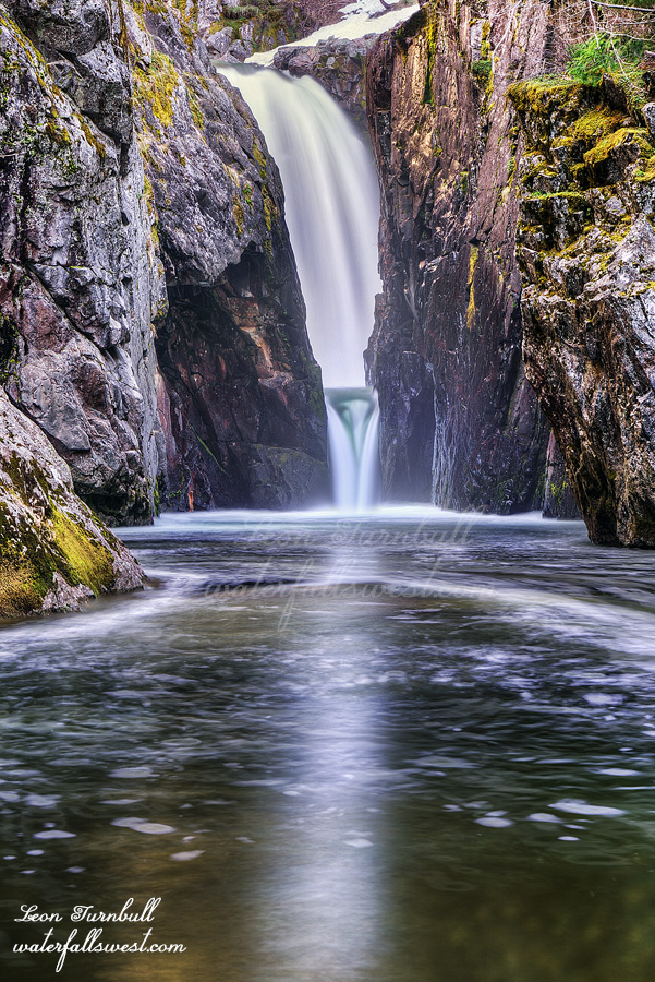
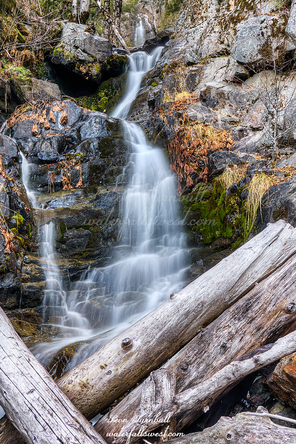
It was not my intention on this trip to go all the way down to Palisade Falls on the river. However, I did go down to NFAR at Heath Falls (pictured here). Going to Heath Falls was not the main reason why I wanted to do this hike again. There was another reason. Actually, three other reasons. Meaning … three brand new waterfall discoveries. You will have to wait for my next couple of posts to see them. Heath Falls, though, was here! How could I not go down to my favorite river and one of my favorite waterfalls? The ever spectacular Heath Falls, 65 ft. high. It was a fantastic day on the NFAR.
Posted in Northern Sierra, Waterfalls by leapin26: April 19, 2021
I was planning to go backpacking this weekend. However, when I arrived at the trailhead I found no place to park! I did this hike a couple years ago and I had no trouble parking overnight, but now there are no parking signs everywhere. So now no one can park here and hike. This is absolutely ridiculous and extremely upsetting, Placer County. This is a public road. There is no reason why we should not be allowed to park and hike here. Well, I will be back here later with a different plan. I am not going to be denied this hike. But for now, I had to retreat. Strike one.
I drove up Foresthill Road in the afternoon. The satellite image seemed to show the road is now open to Tadpole, however, I was stopped before Ford Point. No go. There was not much snow but it was more than enough to stop me. Strike two.
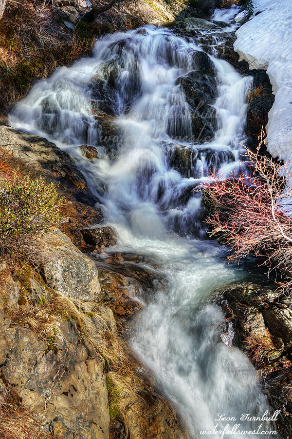
I did not have time anymore to do my planned hike but I decided to just park and walk up the road to Tadpole. There is one waterfall there I have been wanting to check out and this seemed like as good a time as any to do it. It is a pleasant road walk but you do gain about 700 ft. in elevation. I dropped down into the canyon all the way to the creek. It was not “too hard” to get down but it was not easy either. I found this 33 ft. high cascade. Not a very big waterfall but not awful either.
It was in the sun so I had to wait. The problem is I did not research this beforehand so I had no idea when it would be in the shade. I waited an hour, watching the sun closely. While I waited I ate my dinner and then to entertain myself, I threw twigs in the water, trying to get them into a little whirlpool and then see how long it took for the twig to finally get over a mini waterfall. Yes, I am easily amused. Well, after an hour it became very clear that the waterfall would not be out of the sun until sunset. That was still two hours away. There is no way I was going to wait another two hours. It was just not worth it. I still had to climb out of the canyon followed by a long road walk back to my car. I just took some photos as best as I could and left. Strike three. It was an interesting day in Tahoe National Forest.
Posted in Northern Sierra, Waterfalls by leapin26: April 11, 2021
So what is your favorite season? Mine is spring. That may surprise you. Maybe you thought I preferred winter? Well I do like winter, but in spring, the weather is warmer, the snow is melting, and the waterfalls in the high country are roaring. It is time to get out hiking and enjoy them! It will be a very short season this year, unfortunately. As of April 1, the snow pack is at 71% of normal (northern CA), 68% (central Sierra), 46% (southern Sierra). Rain is at 52% (north), 54% (central), 40% (south). It has been a dismal year. This is the second year in a row of drought. Are we heading back into a prolonged drought period again? I sure hope not. Please pray for much rain next year.
The snow is just starting to melt now so I wanted to head up into a higher elevation this week, above 4000 ft. Well, I ended up being a bit below 4000 and unfortunately that meant more poison oak. Sigh.
For this hike, I first saw this waterfall about 12 years ago. I climbed up on the opposite ridge and could only see an obscured long distance view of it. In retrospect, I have no idea why I even bothered to climb the ridge because I should have known it would not be a good view. Since that time I’ve been wondering how I could get close to it, if it was even possible. I had some ideas. The King Fire in 2014 put a delay into those plans, though as it turned out I should have tried to do this one a couple years ago. (keep reading and I will explain).
You won’t be finding this hike on AllTrails. I find it funny that people will only look on AllTrails and nowhere else for hikes. Not every hike is on it! I have so many hikes on waterfallswest.com that you will not find on any other site. This one is not easy, however. The hike is 6 miles one way with an elevation loss of about 1600 ft., so it is similar to the Upper Shirttail Creek Falls hike I did a couple weeks ago, yet this one was much much harder. The last part is a big drop of 500 ft. down to the creek (again, similar to Shirttail). It took a full hour to get down to the bottom. It was hard! The brush after the King Fire has now grown up immensely. It was very brushy, especially near the top of the ridge. At first, I thought I was done for. There is no way I was getting through all that brush, but I persevered and I found a path. It was very steep and there were a lot of fallen trees from the fire. I had to be careful with that but the brush was still the biggest problem. The brush got better near the bottom but that is where the poison oak made a presence (in abundance). I really wanted to be done with the poison oak for this year. Sign. Maybe next week.
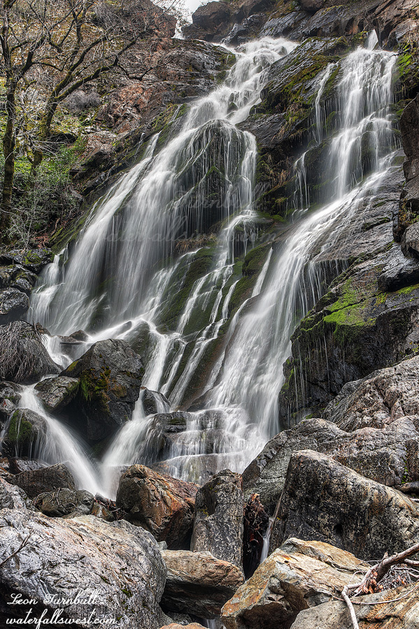
I finally made it down to the creek and the bottom of the main section of the waterfall, a magnificent 161 ft. drop. Onion Creek Falls is absolutely glorious! It was so awesome finally getting up close to this beauty and well worth the effort. But I still had to climb back up the mountain. It was 5PM and it took an hour to climb back up to the road. I was planning to eat my dinner back at the road but I should have eaten at the bottom. I almost bonked. The climb was so incredibly difficult. I rested when I got back up to the road and tried to eat. Now I still had 5 miles to hike and another 1100 ft. to get back to the car. It was well after dark when I finally got back (almost 9PM!), so it was much later than I had hoped and I almost bonked again as I finished the hike. This was a killer tough hike. Was it worth it? Heck yes. It was an awesome day in Eldorado National Forest.
Posted in Northern Sierra, Waterfalls by leapin26: March 28, 2021
The first time I came here, I did not go down to the bottom of the waterfall. I had thought that I would get a great view of it from the ridge but that turned out to be impossible. I went about halfway down the mountain and ran into a plethora of poison oak. I did get a partial view of the falls but I felt that I did not really bag the waterfall and I wanted to return again someday for another try.
This past weekend I returned with full intention of getting to the bottom of the waterfall.
It is a very long and difficult hike. There was a little bit of snow from the previous storm. I was surprised there was snow at all but it was only a couple inches, so it was not hard to walk through. When I got to the ridge I was already quite tired. I still had to go all the way down to the bottom, and then of course back up. I realize now why I went the wrong way the first time. It is very tricky to know the right direction to go and very easy to get lost. Once again, I started going down the wrong way (into the poison oak), but this time I corrected my direction and got over to where I was supposed to go down. There is less poison oak this way, but there still is a bit. It is STEEP! It is incredibly steep! I did not need to use my rope at all but the loose rocks made it very difficult and sketchy and there was quite a bit of slipping and sliding on the rocks, and hoping I would not start a landslide. It is a 600 ft. descent to the bottom. I made it down to the creek and still had to work my way upstream to the falls. This also was difficult and if there was a lot more water in the creek it would have been impossible. I had to climb up the rocks over a couple little cascades and had to put my feet in the water until I finally reached a good viewpoint of this glorious 212 ft. high waterfall. It was magnificent! Upper Shirttail Canyon Falls is into the bag machine!
I ate my lunch down at the waterfall. Relaxing. Resting. Finally it was time to climb back up the mountain. I was not looking forward to it. It was so hard. It took 3.5 hours to hike down and 3.5 hours to go back up to my car (plus about an hour down at the waterfall). Once again, I came across people shooting targets on the final section back to the car. They are so loud and ruined the last bit of my peaceful hike. I had hoped that since it was so late I would not see any of them, but no sir. And as usual I had to pick up all the trash they left behind, which (once again) was a lot. Why are these people so irresponsible. Argh.
Anyway, I had an amazing but very difficult day in Tahoe National Forest.
Posted in Northern Sierra, Waterfalls by leapin26: March 15, 2021
I was surprised there was no snow (or not much) at the trailhead at 5500 ft. elevation. I did not think I’d be able to drive up there, but when I looked at the satellite, I did not see much snow. Maybe this hike to Spruce Creek Falls would be a good one to do right now.
There was maybe just a couple inches of snow so it was easy to drive to the trailhead. It was icy, however. I had fun sliding along the ice as I hiked down the road. Coming back up later would be a bit more difficult. The road crosses Spruce Creek a few minutes into the hike. It was just barely flowing. I really considered just turning back now. But I drove all the way up here. I figured I should at least do a hike down to where I need to get off the road and scramble down to the falls (3 miles of road walking). If the creek is just a trickle down there, then I would not do the off trail (very difficult) part of the hike.
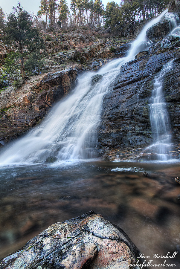
It is about a 1400 ft. descent down to the falls (900 on the road). When I got down to the end of the road, I could hear the creek flowing much better (I could not see it from the road). Ok then, maybe I will continue as planned. I have tried this hike once before, but I found it too steep and cliffy. I returned this time with rope and with a better planned route. (so I thought). The cliffs get really crazy near the top of the waterfall. Cliff cliff, everywhere a cliff. There is no way down. But there is! I found a path leading down to the bottom of the lower tier of the falls. The last section was very steep and indeed I needed to use my rope for safety. I made it down successfully.
This lower tier of Spruce Creek Falls is 39 ft. high. It is quite nice, and you can see the upper tier in my photo. It is much bigger. Unfortunately, I could not find a way up to it. It is extremely sketchy and I did not have any more rope. I was also out of time. I will return in the spring with more rope and more time and more determination.
It was dark when I got back to my car at 5:30PM. It was a cliffy day in Tahoe National Forest.
Posted in Northern Sierra, Waterfalls by leapin26: January 20, 2021
