Sometimes it is not all about the waterfalls. Sometimes it is about the scenery. That is what I am telling myself anyway.
I plan all my trips around waterfalls, of course. Sometimes it does not work out as planned. Especially this year, 2020. For my big Fall backpacking trip, I was not planning to go to this location, I had a different trip planned. The fires. The smoke. That put the nix on my big plan this year. For my alternate trip, Plan Z, I chose northern Yosemite National Park. This was pretty much the only place in all of California where the air seemed all right and not too smoky. There *are* waterfalls here that I had not been to before, and I thought they would be flowing decent, at least a few of them. And you can’t go wrong with Yosemite. I go to Yosemite every year, but this year, I had not been to Yosemite because of COVID-19. I thought I was not going to make it this year, but then Plan Z came into being, and off I went to my favorite national park.
I hiked in from Twin Lakes on the eastern side of the Sierra, hiking through the Hoover Wilderness, over Mule Pass, and into northern Yosemite National Park. I arrived at Twin Lakes on Friday evening. If I arrived any later I would have been out of luck. Apparently, you have to pay for parking here. You should not have to pay for parking at a wilderness trailhead, and I did not think I had to pay. I have hiked here before and I did not pay (though maybe, I was supposed to pay?) There are no signs about parking or about paying for parking, and I was not sure where the trailhead parking was, so I asked the attendant at the campground kiosk, (who was about to close). He told me I had to pay $15. Well, crap. Even though I thought I was being screwed, I payed the $15 and parked. (I don’t think I was being screwed, but I also think there should be free wilderness trailhead parking).
It was after 6PM. My plan was to hike up to Barney Lake and camp the first night. I would arrive at the lake well after dark. I saw one deer just as I started the hike, the only wildlife I saw on the whole trip. The hike took longer than I expected and I did not arrive at the lake until 8PM. (sunset was about 6:30PM). There were quite a few people on the trail, coming down from the lake, even after dark. There was also someone camped at the lake (in the best spot), but I found another place to setup camp, and went to bed.
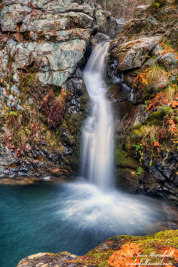
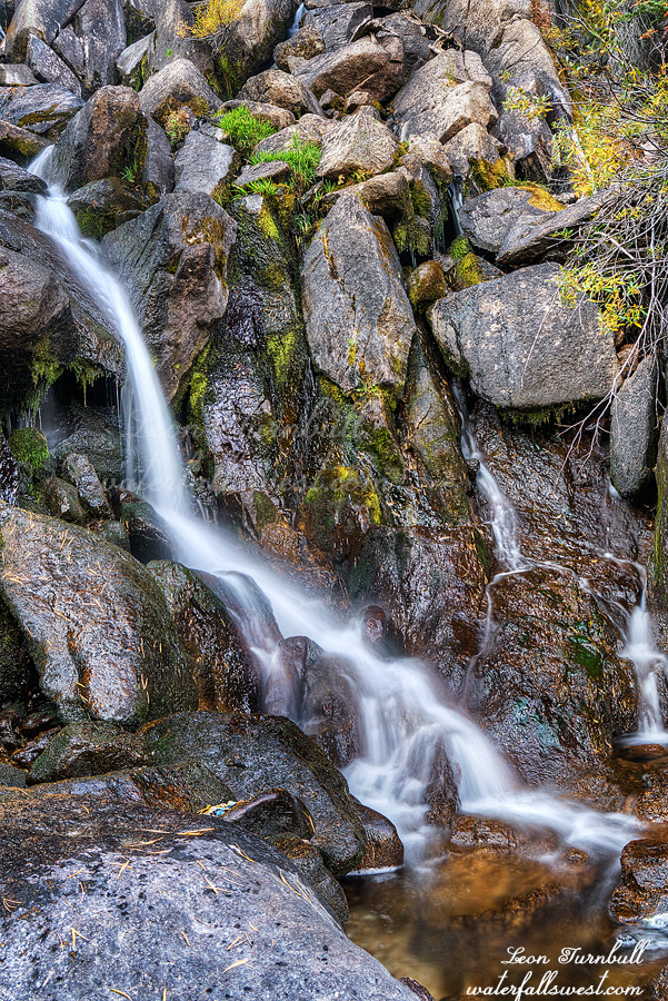
I got up early, packed up, and continued my hike. First stop: Robinson Creek Falls (pictured here). This was the only waterfall on the entire trip. It was not flowing very decent, but I took a photo anyway. It is a big waterfall and would be impressive at high flow (if you can get to it at high flow). It was also quite difficult to get up close to. There is a large rock slide beside the creek. The boulders were huge. This, as I found out soon enough, would be the main theme for the trip: Enormous rock slides. I managed to find a path over the rocks and to the creek, but only by squeezing through a very narrow slot through a couple large rocks. If I was two inches wider I would not have made it (I am not kidding – on the way back I almost could not squeeze through). Once at the creek, I had to cross over to the other side of the stream to photograph the waterfall. In high water, this is not going to be possible, but the waterfall certainly would be much better if you could find a view of it.
So what can I say about the rest of the trip? Are you still reading? This is going to be long, and there are no more waterfalls. But as I said, the scenery is impeccable. It is Yosemite National Park.
Mule Pass is at 10,500 feet elevation. I started at 8300 feet at Barney Lake. It is a killer climb. It was not so much the high elevation, but it was my 40 pound backpack. I think that is what really did me in. This was intended to be a 5 day trip, but I ended up cutting it short because of the lack of water. On the west side of the pass, there was quite a bit of water flowing in the streams, even the small unnamed streams. I thought this was a good sign. Piute Canyon should have a good, decent, amount of water in it. Wrong. On the east side of the pass, there was no water at all. On the descent, I was starting to worry that Piute Canyon would be completely dry. I was almost out of water, and if that creek was dry I would be dead (literally). Also, the smoke was starting to roll in to the canyon from the south and it was starting to get noticeably bad. I chose this area because there was no smoke here! Ugh. I prayed it would clear up by evening. (and thankfully, it did).
I arrived at the bottom of the canyon. I could not hear the creek flowing. This could be really bad. It was a half mile up the canyon to where I planned to camp beside the waterfall. As I continued and approached closer to the creek, I could finally hear a trickle. Whew. I would not die. But it was definitely not flowing much. Not nearly enough for a decently flowing waterfall. This was very disappointing to me. I really thought this creek and waterfall would be good, even this late in a dry year. I camped beside the almost dry waterfall. I was tired. I slept well.
What would I do the next day? I did not want to go home yet. I decided to explore down Piute Canyon. Maybe there would be more water in the creek downstream. The hike started off tremendously well. There is no trail, but it is easy hiking and when the canyon opened up it was incredibly beautiful. Then I came to a dead end. THE SLIDE. I don’t know when this rock slide occurred, it was a very long time ago, but it is absolutely MASSIVE. It spans the entire canyon, from one end to the other, and up the other side (over a quarter mile wide). The rocks are absolutely ENORMOUS, from one end to the other. I could find no easy way past them, and I spent a couple hours trying to do it. This is no simple rock hop! I finally gave up. I think that it can be done and I just did not go the correct way, but I was tired, and I decided it was not worth the effort because of the lack of water. It was time to go home.
I ate my lunch, then proceeded back up to the top of Mule Pass and down the other side. I stopped at Robinson Lake for the night. There was no one there when I arrived (so I got to choose the best spot). Someone came up later, however, and camped near by. I told him I was coughing a lot and would probably be keeping him awake at night. I think the smoke was causing me to cough so much. (it was not horrible, but there was still a little bit of smoke in the air). I hope I did not keep him awake, but I probably did. I did warn him, however, so it is not my fault; he could have camped further away. Anyway, I enjoyed the beautiful alpenglow at the lake at sunset. The next day was a very long and tiring slog back to my car at Twin Lakes. Thankfully, it was all downhill. I arrived at my car at about noon and got home by dinner time. Pizza again (thank you, Tara). It was a good time in Hoover Wilderness and Yosemite National Park.