TOTO, I DON’T THINK WE’RE IN CALIFORNIA ANYMORE

It was an extremely windy afternoon and evening.

PG&E had shut off power throughout California due to wildfire prevention. Our church on Sunday morning was without power and we had service in the dark. Despite the power being off, PG&E still started a massive wildfire in Sonoma county. Good thing your new policy works so well, PG&E. Not.

Indeed it was very cold and very windy. It was so windy it felt as if every other tree was going to fall on me as I hiked. It was so windy it felt as if I was being blown clear across the state. There were many fallen branches and twigs on the road (and falling onto the road) as I drove to my destination. It was an obstacle course to avoid them. I do not normally like hiking in such windy conditions. I’m afraid a tree is going to fall on the road and block me in somewhere. Or worse: a tree is going to fall on my car. Or even worse: a tree is going to fall on me. However, I had not hiked in quite a few weeks and I was feeling the big itch to get out into the wilderness.

Most of my hike would be off road. No trail. Just hiking through the woods, with the wind howling and shaking the trees. Thankfully, there was not that much brush I had to whack through. It was mostly open and nice. When I was out in the open, I felt really happy, but the few brushy parts got me anxious for some reason. It was getting late and I did not want to be hiking back in the dark through thick brush. Well it was a nice idea but …

I arrived down at the river after 5PM. It took two hours to hike that two miles through the forest. I was taking a lot of video along the way, which always adds a lot of time to the hike, but I estimated it would take 1.5 hours to hike back to the car. I figured I needed to start back by 5:30pm at the latest to avoid having to hike back in the dark. Hmmm.

Middle Bear River Reservoir Falls is a really nice one, dropping 41 ft. over a big huge rock. It looked very unique and very interesting. I was very pleased. I went to the upper falls last year (also very nice). This year I wanted to try the middle falls, and overall, it was not that difficult to get down to it, and I did not have to cross the river either. I took my photos as quickly as I could. I did not have much time. It was 5:40pm when I started back.

Here’s the problem: Somehow, I totally miscalculated the time for sunset. I had written down in my notes that sunset was at 6:40pm. It was actually at about 6:05pm. I was wondering why it was already so dark as I hiked back up the mountain. I know I am in a deep canyon, but it should not be this dark. By about 6:20pm, it was pitch black (just like the rest of California). I was not even back to the brushy section yet. Now I had to hike through that stuff in the dark, which is exactly what I did not want to do. Not much I can do about it, though. I got out my headlamp. It did not turn on. The batteries were dead. Why did I not check this before my hike! I did not even think I would need it for this hike, which is probably why I did not check it. Well, at least I had my iPhone light. Not quite as nice but it worked. I managed to make it back through the brush and got back to my car at 7PM. It was still extremely windy. Thankfully, no tree had fallen on my car. It was a great little hike at Bear River Reservoir.


No Comments

DAY 2.5 PLAYING THE SLOTS

This is Upper Cascade Falls, 151 ft. high. It is a fascinating little slot canyon here, and the viewpoint is incredible. Imagine this at peak water flow.

Even though it was windy, I slept pretty well. I was very tired. I had initially intended to get up early and hike in the dark, going back on a different and longer trail, and also seeing one more waterfall along the way (which is why I needed to hike in the dark). However, I was just too tired and did not feel like getting up and hiking in the dark. I decided that getting a couple hours more sleep would be a better plan. I hiked back on the same trail, 12 miles back to the car. Most of it was downhill, thankfully. Surprisingly, I saw quite a few other backpackers coming up the trail. A bit odd because it was a Sunday. I arrived back at the trailhead at 12:30pm. I got home at about 4PM, ate dinner, and went to bed at 7PM. I was so tired, and slept for 10.5 hours that night. It was an awesome trip into the Hoover Wilderness!

No Comments

DAY 2.0 MAD ES-CASPADES

After packing up camp, I ate my breakfast and set out. I had about 9 miles to hike to where I intended to camp that night at Cascade Falls.

There was another group of backpackers hiking along the same trail as I was hiking. We kept passing each other along the trail. I would rest, they would pass me. They would rest, I would pass them. This kept going on ad infinitum and got to the point where it was a bit ridiculous. At least they were not going to the same place that I was going.

The hike was pretty much all uphill, and even though it was not a huge elevation gain, it was very tiring. By the time I got to Cascade Falls, I was spent.

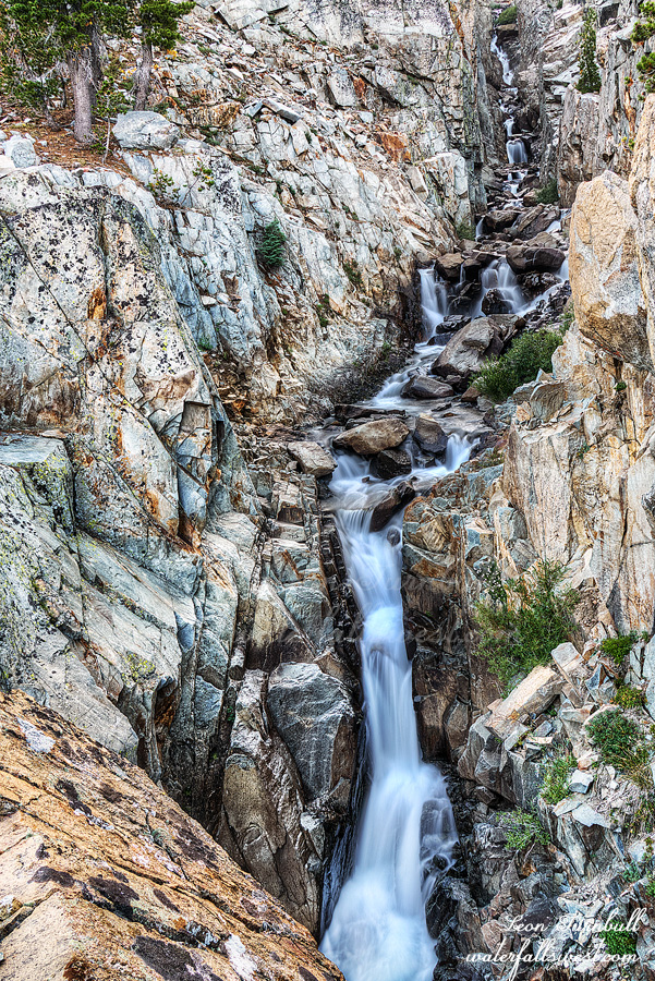
There was no camping at the lower (main) falls, so I kept climbing up the mountain to a spot in between the lower and upper falls. This was where I expected to find my place to camp. You most likely did not know there was an upper falls here, and probably did not even know there was a lower falls here, even though the lower falls is marked on the maps. At the very least I am sure you have not ever seen it or seen any photos of it (I will explain this below). The trail seems to be well maintained but not well traveled (at least, not well traveled on the waterfall section). It is very rocky in places and also very sandy in other places. The sandy part is because of all the mules that go on the trail. They beat up the trail to death, making it very sandy and difficult to hike on. Not to mention all the crap they leave behind that you cannot avoid walking on (pet peeve). I was not sure which I hated more, the sand and mule crap, or the rocky terrain. Believe it or not, I think I prefer the sandy terrain. The rocks just kill my feet horribly.

It was very windy when I arrived at the campsite. I was expecting this, and worried about setting up my tent in the wind. I have a new tent, the Zpacks Duplex. It is expensive, but it saves two pounds. Is it worth two pounds in savings? Well, the jury is still out on that, but the reviews on this tent are very good, and so far I like it. However, it was blowing around like crazy in the wind, much too much for my liking. I read about a trick on the internet, to set it up lower to the ground when the weather is like this, so that is what I did. It worked and held up just fine in the wind, however I think I should have set it up a bit higher than I did. I will know better for next time.

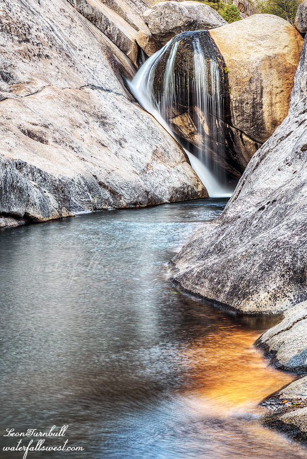
After eating my dinner, I went down to the lower falls. The reason you most likely have never seen any photos of this waterfall: you cannot get down to it! Well, let me explain. The trail goes right by the falls on the north side of the creek. You most definitely cannot see the waterfall from this side. It is way too cliffy, impossible to get down to the creek level, and to top it off, the waterfall is hidden behind a corner with cliffs on each side. No wonder I had not seen any pictures of this waterfall before! But the waterfall madman is not to be outdone so easily. I did not hike 12 miles to see nothing! It seemed to me that I would be able to see the waterfall from the ridge on the other side of the creek. So I went back down the trail all the way to the bottom, bushwhacked over to the creek, crossed the creek, climbed up the steep and crumbly embankment on the other side of the creek, and started climbing up the ridge back to the waterfall.

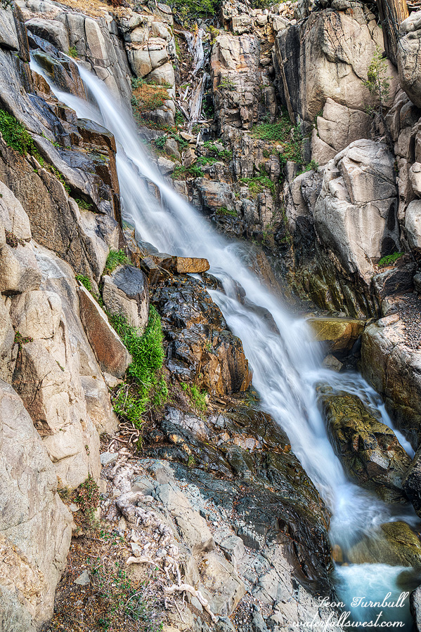
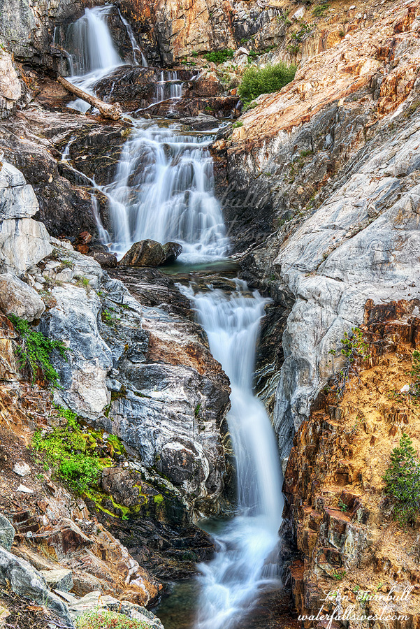
And voila! The madman strikes again! I came to an awesome viewpoint of Cascade Falls, an absolutely gorgeous 59 ft. high three tiered waterfall. What a perfect view!

I did not want to go all the way back down to the bottom and cross the creek again back over to the main trail, so I just continued up the ridge on this side. I knew I could get across the creek easily at my campsite, and in fact, I should have come down this way to begin with, but I wanted to see if I could get down to the falls on the trail side of the creek first (which, obviously, I could not). It was very easy climbing up the ridge back to my campsite (well, relatively easy).

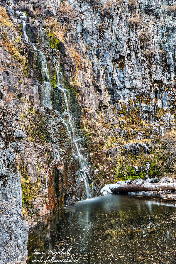
After crossing the creek at my campsite, I continued upstream to the upper falls. This was much easier getting to than the lower falls (thankfully!), and I found a great view of the upper falls (on the edge of a cliff, of course), which is 151 ft. high, and reminded me a lot of Twin Island Lakes Falls. (photo is coming). The lower falls reminded me a lot of Carson Falls (because of all the cliffs and scrambling around to get a good view). It is funny how some waterfalls are so similar to each other.

The upper falls is hidden and not right by the trail. I suspect 99.99% of the people hiking this trail have no idea there is a waterfall here. I saw no evidence anyone had ever been here before. I also thought it funny how close these waterfalls are to the Pacific Crest Trail, but probably 99.99% of the people hiking the PCT have no clue there are waterfalls here, and even if they did know, they would not take the time to go down to either of them. This is why I would never want to hike that trail. I would miss seeing far too many great waterfalls and other sights. Anyway, I headed back to camp and to bed on this windy night.

No Comments

DAY 1.5 FALLS-ING IN LOVE

After work on Friday, I drove to Sonora Pass. The plan was for a quick one night backpacking trip, but it turned into two nights.

At first, my idea was to sleep in the car on Friday night, then get a very early start on Saturday morning, hiking in the dark, in order to get to the first waterfall before the sun on Saturday morning. I did not really like this idea too much. I like sleeping a bit better than hiking in the dark.

I decided to change things up a bit, and hike in part way on Friday night (in the dark). So much for not hiking in the dark. However, this would put me close to the first waterfall, and then I would not have to get up so early the next day. This is what I did.

At the trailhead, I talked to a couple who just came off the trail. They said the mosquitoes were out. I was bummed to hear this. The madman does not like mosquitoes. Nonetheless, I did not encounter a single mosquito on this first day. I’m not sure where they thought they saw any mosquitoes, as they were coming from the exact place where I was going. There were a few around the next day, but mostly they were a non-issue. Even so, I would much prefer ZERO mosquitoes than even ONE or TWO mosquitoes.

I started hiking at 7:15pm. Sunset was 7:30pm. It was dark 15 minutes after that. I had about 3 miles or so to hike, and it was an uneventful hike except for when some birds freaked me out as I walked by them. Also, I saw a nice little snake right on the trail. It was not a rattlesnake, it was a rubber boa snake. I have only seen this type of snake once before, so that was cool. More cool than seeing a rattler.

I arrived at Roosevelt Lake at 8:30pm, 3 miles from the trailhead. I wasn’t sure I wanted to camp here, but there was a nice big spot by the lake, and even though it would be nice to get a little closer to the waterfall, I did not really want to hike anymore in the dark, plus I was not sure there would be any flat spots further up the trail (there was not, as I found out later). I stopped here and set up camp. I was in bed by 9PM. Not a bad evening.

In the morning, I got up early but not too early, and hiked up to the waterfall. It took a lot longer and was a lot harder than I expected.

I crossed the West Walker River by butt scooting across on a log, then followed Falls Creek upstream.  Even though I know we had a fantastic year, I was still surprised at how much flow there was in both the West Walker River and Falls Creek. It is September, after all. I was half expecting Falls Creek to be dry as it is a pretty small drainage, but with this flow, the waterfall should be terrific (if I can get to it). It gets steeper and cliffy-er as you get closer to the falls. I was hoping to get a good view of the waterfall without having to climb half way up the mountain, but unfortunately, you cannot see much of the falls due to a lot of thick brush along the creek. There was also no way to get to the creek through all the brush. The only choice was to keep climbing higher. Going higher meant getting above all the brush, but now I had cliffs to deal with. Getting to the falls seemed impossible, and now it was getting late. The sun should already be hitting the falls. But it wasn’t. I kept climbing, and finally found a good way over to the creek. I was standing on the edge of a cliff, but I could see the biggest drop of the waterfall from here, a marvelous 45 ft. high horsetail fall. The entire waterfall is bigger than this, but you cannot view all the tiers at one time (or really, any of the other tiers at all).

When I go backpacking, I want to pack as light as possible. This means I leave my laser rangefinder and clinometer (for measuring waterfall heights) at home. I meant to take these out of my pack, but I forgot. That was stupid and added an extra 1.1 pounds to my pack. You might think that is not very much, but every single ounce adds up enormously when you are backpacking. Well, at least you now have the exact heights of the waterfalls from this trip. You are welcome.

After this, I went back down the mountain to photograph the Lower Falls, which was still in shade but not for long. Then I hiked back to camp, packed up my gear, and had my breakfast. So far, it was a fantastic morning.

No Comments

DAY 2. LITTLE FLING

It was colder during the night than I anticipated. It’s weird how last week it was warmer than it should have been, and this week it was colder than it should have been. Maybe it’s just me? When I got up in the middle of the night to do my thing, the zipper on my tent was ended. Remember how I said it broke last week? After that, I rigged it up so it would work, and open and close if I was very careful. Well, I was being careful, but nonetheless, it tore wide open. This time there was no fixing it whatsoever. I knew this would happen eventually, I just hoped it would not be tonight. I zipped up the outer door, but the inner door was wide open. That meant things could still get in such as: bears, snakes, and bugs. I was hoping and praying that none of the above would actually get in. I’m not sure what would be worse. Bears would be worst, but I was not worried about that. Snakes would be next worst, and that was a very real and scary possibility. but the mosquitoes is what I was most concerned with. I hate hate hate the mosquitoes (I think I may have said that before). Fortunately, there were very few mosquitoes and I am thankful nothing got in my tent during the night (not even any ants!).

This small 10 ft. waterfall was right beside my campsite. Since it was there and since I was there, I decided to take some photos of it. It is kinda pretty.

After breakfast and packing up, I headed up the mountain. I had 1200 ft. to climb to the top of the ridge, then down to the trailhead. It was very slow going through the snow. I got back to the car at 12:30PM. That is 6 hours to hike 9 miles (it took 7 hours on the way in). I was beat up from all the snow hiking, but I had a great couple days in the Mokelumne Wilderness.

No Comments