As of Jan. 1 here is the current California winter status. Snow pack is at 161% (north), 94% (central), and 72% (south). Rain is at 134% (north), 71% (central), 70% (south). As you can see the north is doing well so far but not the rest of California, and now we are heading into a 3 week dry period to begin the new year. La Nina is nowhere in sight. Argh.
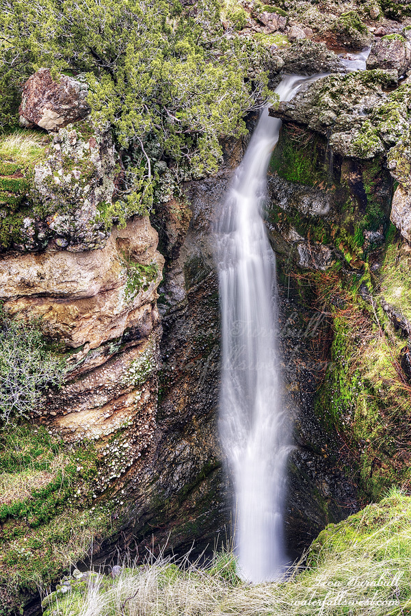
We were on our way to visit my family in Canada near the end of December. It was a rain day. Streams were flowing out of nowhere down the mountain sides. When we go to Canada I do not usually like stopping too much, especially the first day because it is such a very long day and very long drive. Certainly there is no time for a long hike. However, it seemed like I should stop somewhere. All the waterfalls were going nuts. I made a couple quick stops. The first stop did not work out because there was a big creek to cross which would require getting wet and I was not prepared for that. The second stop was just to little Sweetbriar Falls. I have not been to this one in a long time. The waterfall was flowing crazy. The Sacramento River was flowing crazy. It was pretty cool to stop here. Too bad we are now heading into a stupid dry period. Sigh.
Christmas Day. The family was up at my mother-in-law’s place for the festivities. These days that means everyone sleeps in til noon before opening presents. It is especially hard getting my daughter out of bed. The problem: I wanted to take Journey on a hike in the afternoon. Normally I would go on the 26th or something and take it easy on Christmas Day. That would not work this year, however. A storm was on its way and it was going to rain every day for the rest of the week. The 25th was the only possible day to hike. Somehow I got my daughter out of bed. I bribed her with coffee from Starbucks. (why is Starbucks open on Christmas Day anyway?) We opened all our presents and were finished by 12:30PM. It was a Christmas miracle.
I’m not so sure Journey even wanted to go on a hike. She got a lot of cool presents which she was really happy about and just wanted to play with them all morning. Once we got to the trail though she was excited about the hike. Of course she was.
I have never been to this waterfall in Red Bluff before although I have known about it for some time. It is dry most of the year so the conditions need to be just right but we had quite a bit of rain recently. I was pretty sure it would be flowing and it seemed like a perfect day to try it.
There was water out-flowing from Hog Lake and quite a bit of it. Another Christmas miracle. The Madman was happy. Journey was happy. She got to be off leash for the entire hike. We saw no one else around (except for one other couple). There were bugs on the beginning section near the lake. Why were there bugs? It is winter! I thought it was a bit strange, it must be horrible here in summer.
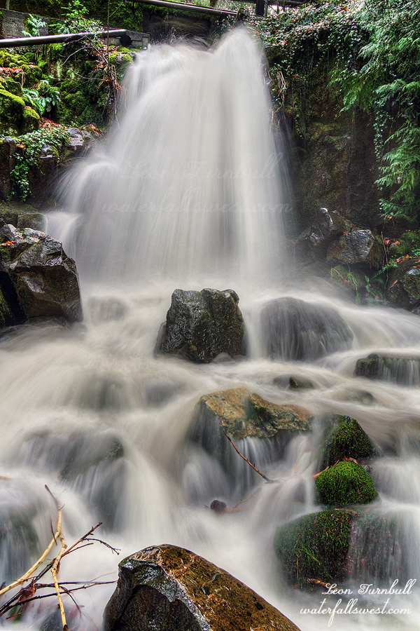
It is an easy trail down to the waterfall. At the end the trail is a bit rougher and hard to follow but it’s not bad. Journey had no troubles. Once at the waterfall it is a bit dicey. You cannot see the waterfall unless you get right to the edge of the cliff but that is suicide. The cliff seemed very unstable. I did not want to get too close to it and I kept Journey well back from it as well. Fortunately there is a big rock that you can climb up and get a better perspective looking down on the falls. Journey waited patiently as usual while I climbed up to take photos. Turtle Creek Falls is 30 ft. high exactly. It is a pretty little waterfall in a very unlikely location. We had a wonderful Christmas Day hike in Red Bluff.
Journey is not a morning person (dog). Just like her momma, she loves to sleep in. I am a morning person though and if I am hiking I need to get up at the break of dawn (or earlier). That means Journey needs to get up also (if she is coming with me). Once we get to the trailhead she is excited but getting out of bed is the problem. She does not want to get up! This was the situation we found ourselves in on Black Friday.
It probably didn’t help much that it was very cold. About 33 degrees. Brrr… We arrived at the trailhead. Now Journey was excited. Let’s get on that trail and get warmed up.
The plan was to go to Whiskeytown Falls. Journey has never been to it so this is another one I am re-visiting so I can take her to all these beautiful waterfalls. We saw no one at all there and back so she got to be off-leash for the entire hike. A bit surprising but I guess everyone was out shopping or something. Whiskeytown Falls was the hike where my previous dog Kaya almost went over the waterfall. I was not paying attention to her while I was photographing it and she slipped in the stream and almost went over (thankfully she caught herself just in time). I was paying attention to Journey this time as I photographed the waterfall but there is a railing there now so it would have been hard for her to do the same thing. I’m pretty sure there was no railing when I brought Kaya here. Journey just waited very patiently for me. She is such a great dog.
The upper tier of Whiskeytown Falls is now very ugly and un-photogenic. There is a huge awful branch blocking the waterfall and it is not adding any character to it. Someone needs to cut that thing. Perhaps God will take care of it eventually but it could be a few years. The lower tier is a bit better. I let Journey wander around as I photographed it and I was not paying much attention to her but there was no waterfall she could fall down if she slipped in the creek. We finished photographing and hiked back to the car. It was a cold brisk morning at Whiskeytown Falls.
Thanksgiving Day. Just five days after the Bomb Cyclone. I returned to North Table Mountain on my way up north to visit family. Without Journey this time. One, she was with her momma. And two, I had hoped to find a way to the bottom of Flag Falls which I knew would be very difficult (if even possible).
The water was much reduced from five days prior. Much more so than I anticipated. Over ten inches of rain here but flows are already back to below normal and now we are in an extended dry period. I pray it gets much better in the last half of December. I did not have much time but I always find it impossible to bypass Ravine Falls and Phantom Falls without taking photos. I do think I got a different composition of Ravine Falls this time so that makes a quick stop more than worthwhile.
I continued past Phantom Falls. I did not notice the dead cow right at the stream crossing above the waterfall. How could I not notice this!?!? I was clearly not paying attention. I thought it was a log I was walking over, not a leg. I must have come within inches of stepping on it. On the way back I definitely did notice it. Its rib cage had been ripped open by a mountain lion or coyote. There was no smell so it must have died (been killed) very recently. On the far side of Phantom Falls I always see plenty of cow bones and today was no exception (in addition to the dead one along the stream).
I arrived at Flag Falls. I took photos from the viewpoint and thought about my options. I realized that it would take at least an hour to get down to the bottom of it, if it was even possible. I only had about 15 minutes before the sun was on the waterfall. Not worth the effort. I will have to come back another day. I retreated past the dead cow and back to Ravine and Ravine Twin Falls and took more photos there. Then I continued north to see my family for Thanksgiving. So long, Table Mountain, and thanks. Until next time.
Bomb Cyclone 2024. Over 10 inches of rain in 3 days. The waterfalls should be rockin if I pick the right place. I was definitely going to hike on Saturday. But where? My initial plan was to go the Bay Area, however I learned on Friday the road was closed to the place I was wanting to hike. Now what? Somewhere else in the Bay Area? It had to be somewhere that Journey could do fairly easily. I decided to return to Phantom Falls in Oroville.
How would the Phantom be flowing today? It should be pretty amazing. It should be incredible. As I drove up to the trailhead I always look to Schirmer Cascade. This will tell me how the rest of the waterfalls on Table Mountain are flowing. I could not see Schirmer Cascade at all! It was completely enveloped in fog. I think God wanted to surprise me at Phantom. I wondered.
I arrived at the trailhead 30 minutes after sunrise. There was already a car here! Who else other than the Madman would be out on the trail so early? There is another crazy person around here? I wondered.
I also realized I forgot my tripod at home! Doh. That was stupid. I usually always keep it in the car but I took it out for a certain reason and forgot to put it back. Ugh. How am I going to take photos of the waterfalls today? I wondered.
Journey was ecstatically happy. The previous day she had been cooped up in the house all day. Not able to go outside because of the rain. Not wanting to go outside because of the rain. I promised her we would have fun on Saturday. She was so excited to start the hike! There were no cows at the beginning so I let her off leash. I had to keep a close watch. It was foggy which made it more difficult to see and you can quickly come up to cows if they are hiding just over the next hill. Before we reached Ravine Falls we came across a big conglomerate of them so I put her on the leash. They were right on the trail so we had to go a bit cross country to get around them. At this time I saw someone coming back on the trail. He was talking to himself or someone on the phone or to the cows. I don’t know. We chatted a bit when we reached each other. I quickly realized I knew this person! It was my Facebook photographer friend Bradley. It was very cool to meet him. He had been out at Phantom Falls for sunrise. That is what I should have done but Journey woke me up a couple times in the night and I slept in a bit too long. I would have gotten some great shots of the waterfall in fog had I been up in time but now the fog was all gone. When Bradley realized I had forgotten my tripod he very generously offered to let me borrow his but I declined. I would figure out how to get a decent photo without a tripod.
There is a big creek crossing at the bottom of Ravine Falls. The waterfall was flowing very strong. I was worried Journey would not be able to cross the creek. I thought I might even have to carry her across it. She does not like creek crossings and this would be a big one. In fact, it was her biggest creek crossing yet. The water was up to her belly and she crossed it like a trooper. I was very proud of her.
Before we reached Phantom Falls the rain started. It was not supposed to rain for another two hours! Darn those forecasters again. It was raining and also windy and cold when we reached the viewpoint. Journey is usually extremely patient with me as I take photos but not today. She was cold and wet and not wanting to stand around waiting for me. I do not blame her. We did not spend much time at Phantom Falls and were soon on our way back to the car. I managed to get a decent shot though. Not too bad for no tripod in the rain and wind!
Phantom Falls was amazing. It is not the biggest I have ever seen it though. After more than 10 inches of rain I thought it might be even bigger. Nonetheless, it was a terrific and very wet morning at North Table Mountain.