
It’s a Waterfall, Batman!
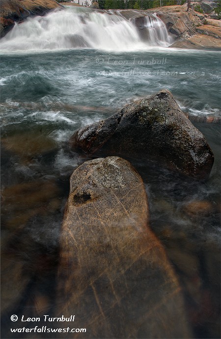
What is this? A waterfall in California with spring time flows in late September? Impossible, you say? But ’tis so, my friends. This is Fordyce Creek, near Emigrant Gap, and it is flowing just dandy. But how can this be? A ha, well that is the question, isn’t it? Fordyce Creek is a controlled water way, and this month PG&E has been dumping water from the upstream dam at Fordyce Lake, in order to facilitate making repairs on the dam. Great news for kayakers and waterfall hunters. Normally, this creek would be just a trickle at this time of year. There are two small but decent waterfalls on Fordyce Creek. This one is called Fordyce Falls (brilliant name, eh?) and it is 13 ft. high. But a word of warning: if you are reading this and decide you want to go, you’d better do it quickly cuz PG&E will be turning off the tap very soon (it is already half the flow it was when I was there last week).
Now admittedly, the waterfalls on Fordyce Creek are really nothing to write home about (13 and 15 ft. high), and it is a fairly long hike to go see them. That’s probably why I hadn’t been to them before now, though I did make an attempt a couple years ago. Nonetheless, when I learned that PG&E was releasing water, I figured that this was the time, and I immediately made my plans to go.
Since it is a long hike, I wanted to start hiking in the dark, in order to be at the falls by sunrise. I figured it would be easy to find the trailhead in the dark since I had been there before. Not! I had remembered there being a sign along the road at the trailhead. I found no signs, except a “no trespassing” sign. Could this be the right place? It just did not seem right, but I could not tell in the dark, so I decided to wait around the for the light. Fortune (I mean, God) was with me, as it was an overcast day, and thus it did not matter if I made it to the falls by sunrise; the light would still be good for photography. When it did get light, I was able to find “a trail”, and it wasn’t at the no trespassing sign, but it still wasn’t how I remembered it at all, and I ended up trampling through the forest using my GPS to guide me, until I finally got on the correct path that I remembered.
When I was here a couple years ago with my dog, Kaya, PG&E at that time was letting out water at Fuller Lake. The trail proper crosses the outlet of Fuller Lake (at a waterfall), and thus I came to a dead end, as I was not able to cross that raging stream, or I couldn’t get Kaya across, or maybe both (it was quite awhile ago, and my memory is fading). This year, the outlet stream was dry and it was easy for Kaya and myself to continue on. I wonder if she remembered that hike before – not likely, I couldn’t even remember it.
The trail leads down from Fuller Lake to Spaulding Lake, and then follows that lake to the end, where Fordyce Creek dumps into it. I was relieved when I heard Fordyce Creek and that it was flowing well (I was worried they might have turned off the tap). The trail then continues up Fordyce Creek, but well away from the creek. This was not good. The trail wouldn’t even go near the waterfalls, and I would miss them. Eventually, though, the trail wound its way back to the creek at the base of the 2nd waterfall. It was easy to get down to the creek to photograph it, and it was flowing beautifully. To get to the other waterfall, I had to back track down the trail to a spot where I could scramble over to it. It was not difficult to do that (for myself or Kaya). All in all, it was a fabulous day, and I was happy to finally get out to see these falls.
2 Comments