
PARADISE
Another rainy day in Paradise! Not Paradise the town. (close to it). A brand new spectacular waterfall discovery! Who could ask for anything more! It was a fantastic day for the madman.
I was not sure where to hike this weekend. It looked to be very rainy on Saturday around where I live. But the forecast said there would not be much (if any) rain in Oroville on Saturday morning, and it would be clearing. Yeah right.
So off to Oroville I went. It was raining there. Surprise surprise.
I was looking for a brand new waterfall, and this one was way out in the boondocks. A very long drive. Almost all the way out to Seven Falls. In fact, I was hoping to do a couple hikes this morning. After this first one, which should be easy, I would then hike down to Seven Falls, which I have not been to in a long time. I figured this first one would be an hour in, and then an hour back. So I should have plenty of time for Seven Falls, however it was actually two hours in and two back. It was 11:30 when I got back to the car. It was too late to go to Seven Falls. The sun was out by then. Not to mention I was very tired, and very wet.
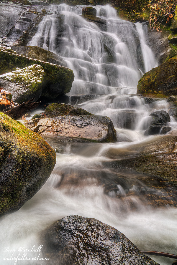
Yes it was raining. And even snowing off and on. There was a bit of snow on the road at 4000 ft. elevation. Not too much, just a little. Just enough to make sure I drove slowly and carefully, as it was quite slushy on the roads. There was even a little snow down at the waterfall (as you can see).
My GPS stopped working. I’m not sure what happened, but it would not write or format the SD card. I tried another card as well, so I don’t know what the issue is, but I am bummed. My GPS is very reliable, and I really love it. For this hike, I loaded my maps onto my iPhone and Gaia GPS app. It worked very well, but I don’t trust the phone to the same level of reliability and now I have no backup. You may think: what do you need a GPS for anyway? Well, you can say that if you are always hiking on a trail. But if you are hiking in the woods, with no trail, in steep canyons, and not following any significant landmarks (such as a creek), a GPS is an absolute necessity. How are you going to find your way out of that canyon? Even if I am on trail, I like my GPS for a couple reasons: I like to see exactly where I am and how far I have to go, plus I upload my GPS tracks to my website so my customers (you!) can download into your own GPS.
Anyhow, back to the hike. I was 95% sure there was a waterfall on this creek, but I could not confirm it on Google Earth. No one else has ever been here and documented this waterfall. So I had to check it out on my own. How should I go there? It looked less brushy on the north side, but then I would have to cross the river, which I may or may not be able to do, especially after all this rain. On the south side, it looked steep and brushy. There was a trail shown on the USGS topo maps, and I found it, sort of. It started out fairly well, but shortly into the hike it became pretty much overgrown and not much of a trail at all. Mostly, I was just hiking through the woods. It was not really that brushy, except for a couple spots. And it was not too steep until I got down to the creek. And bonus: there was no poison oak! Considering it is very close to Seven Falls (which is abundant with oak), and about the same elevation, this was a big and very welcome surprise.
I got down to the falls, I could see it, but how could I get up to it? There were very steep dropoffs into the creek. The ground was slick and wet. Nonetheless, I made my way down to the creek, and then up to the falls without too much trouble. I had to get right in the creek and up on some rocks to get a good view of it, a gorgeous 43 ft. high cascade. It was still raining, but I did a better job taking photos of this one (just a little better). On the way back up the mountain, the sun started to come out, but I was a wet sloppy dog (again!) by the time I got back to my car.
Please see my website if you want to know more about this waterfall:
http://waterfallswest.com/#recent