SURPRISE
In search of a brand new waterfall this weekend, and I found one, but not the one I thought I would find.
There is supposed to be a nice cold storm coming in this weekend, but waking up in the morning, there were not any clouds around. Where is that darn storm? I could have taken the car since the roads are all paved, but it was supposed to snow at very low elevation, so I thought it best to take my SUV in case it started snowing early. It did not snow early. In fact, it was sunny all morning long. Where is that darn storm anyway? Even now, as I write this in the afternoon, it is still sunny.
I wondered about driving on this road (Iowa Hill Rd), thinking it could be closed or very damaged. Its counterpart (Yankee Jims) is closed. As I drove down the road, you can see there were at least a couple big mud slides in the last month, but they have been cleared out now. Damage to the road from erosion is also evident, but it is not overly bad and not dangerous to drive. Once on the other side of the river, however, the road becomes very steep, and very narrow. I hate driving these narrow roads, even more so since the edges are eroded from the February storms. I have only driven up this road once before (and did not drive back down the same way – I went back via Yankee Jims – which obviously I cannot do today). Today I would have to drive back down the same way, and pray like mad that I would not meet another car coming up the hill at one of those very narrow sections. This road really freaks me out.
I arrived at the trailhead and found a nice wide dirt logging road on which to begin my hike. Sweet. It did not last too long. Sooner or later, I would have to exit the road and descend down to the bottom of the canyon. Sooner came sooner than you might think, and off the road I exited. It was very brushy. It was not supposed to be so brushy, according to Google Earth, that is. But indeed, it was very brushy, and I did briefly consider quitting already or at least trying further back up the road. I did not want to bash my way through all that manzanita brush. However, I found a way around it. Once I got around the bad stuff, the going was much easier, and not as brushy. There was poison oak, but it was not bad, and I think I managed to avoid touching any of it. When I got back home later, I still scrubbed down with Tecnu, just in case. Better safe than sorry. I find that 95% of the time if I do this, I will not get a rash. At this time of year, I am in the poison oak a lot.
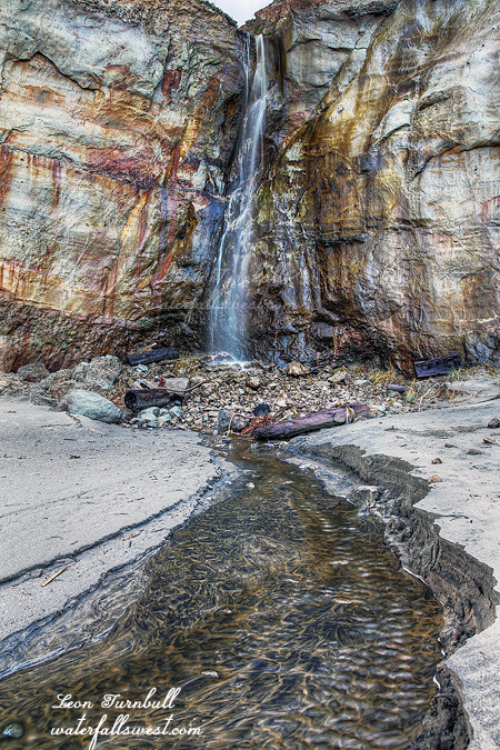
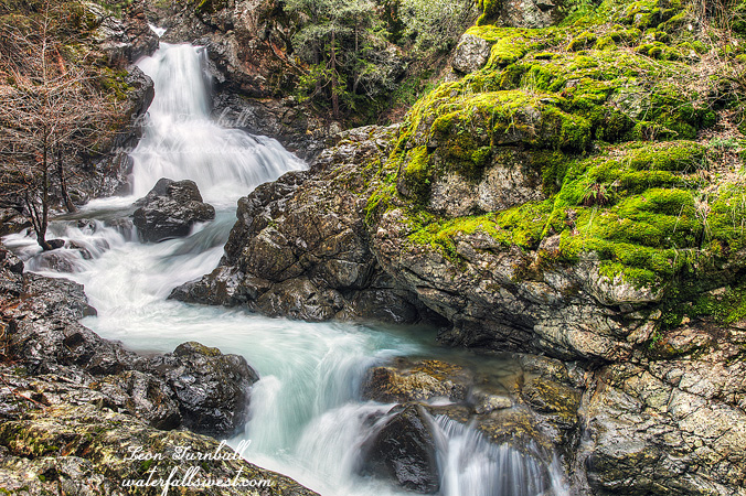
I continued down to the creek. The very last section was quite steep and slick because the ground was dripping with wetness from some hidden underground spring. I had to use my rope to get down this last part safely, but I got down and found this stunningly gorgeous 28 ft. high waterfall. Fantabulous! But … this was not the waterfall I was expecting to find here. I was looking for a different one, and I was pretty darn sure I was in the right place. Instead, I found this other brand new darling falls. Hey, who’s complaining? Nevertheless, I do wonder where that other waterfall is. A return trip is going to be required here. But first, I will need to go back to the drawing board.
Anyhow, I climbed back up the mountain through the oak and brush, and made it back to my vehicle in good time. My prayers were answered, and I met no cars coming up that narrow road. It was a beautiful morning, but bring on that snow already.
No Comments