SOLO
Well I bought all this fancy equipment for backpacking, I figured it was time to try it out. The idea being that with backpacking I can get to more waterfalls then I could on just a day hike. I tried. I got to two waterfalls but I had three others in mind that I could not get to due too steep terrain and crazy thick brush. I was hoping to take my son with me this time but he was feeling a bit sick this weekend. I did not let that stop me, however, and this became my first ever solo backpack and it was pretty darn good.
I would backpack to the end of Hell Hole reservoir where there are two waterfalls and camp in the vicinity. Good plan. Easy smeasy. Right? Not quite. It is a long drive to the trailhead and it was rather interesting. This was my first time driving through the King fire that devastated this area last summer. The destruction is catastrophic. Wow. When I drove through the Rim fire earlier this spring there was lots of growth and wildflowers blooming abundantly everywhere. Not so here, not even close, but give it another year perhaps. I thought the Hell Hole area would be equally devastated but it did not seem to get hit hard. I was surprised but pleased about that.
The trail follows a jeep trail on the north side of the reservoir. This is not any jeep trail for the casual driver. It is only for the sick. Crazy steep descents, and huge boulders to manipulate. It is 6 miles to the end with a descent of 1000 ft. It was not going to be fun coming back up the next day. There were other cars at the trailhead which meant some of those “sick” people were out on the trail with their jeeps. I would not drive this trail even if I had one of those jeeps. I wondered if I would see them, and yes I caught up to them 3.5 miles in. A whole bunch of them. They were stopped right in the middle of the road at a particularly nasty steep section. I asked the first guy I saw if they were stuck. He said no, just hanging out. Really? Hanging out in the middle of the road? The next guys I talked to said their car was broke and they’ve been there since 3am. I was not sure what to believe now. I continued on my way leaving them behind in the dust of my boot tracks. They seemed nice but I did have to pick up one of their beer cans on my way back. You have a car and you can’t take your trash but instead have to let the weary backpacker with a heavy load pick it up? Argh. At least it was only one can. If I had to pick up two my back would have broke.
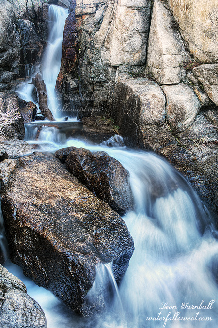
The jeep trail ends at 4 miles officially, but not exactly. It continues straight through the middle of the reservoir instead of alongside it. Well that’s ok I guess because the reservoir is so low due to the drought. I had been fairly certain (though I’m not sure why, now) that a hiking trail continued from here but I found no such thing. So instead I just walked through the reservoir. It was very easy. In the meantime the jeepers got their car fixed (or whatever) and passed me up along this section (quite noisily I might add), but I caught up to them again at the end of the reservoir. I found out they were going to camp at the first waterfall. Ok then, I’ll not be camping there, I was hoping for a quiet and peaceful night, not a noisy one – but the guys I talked to did seem quite nice and talkative and generous – even offering me a ride. They said they had seen mountain lion tracks in the sand when they were here a couple weeks ago and were freaked out about that, and indeed, there were lots of animal tracks in the soft sand. The deer prints were easy to recognize, but there were also bigger prints. Bear? Lion? Yes on both counts, I think. Now I was starting to freak out myself. Well anyway, I beat them to the first waterfall (I am superhuman and can walk faster than most vehicles). Hell Hole Falls is a nice 30 footer dropping into the reservoir (the empty reservoir). When the lake is full this waterfall is completely inundated. Today it was just gorgeous.
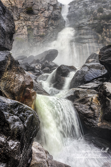
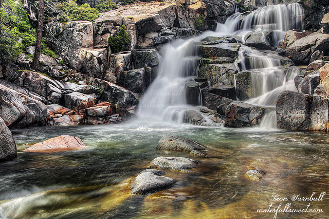
I continued on to Five Lakes Creek. Again I understood there should be a trail all the way to this falls but I could not find it. I decided to cross the creek and try on the other side. I had been expecting that all creek crossings including this one and the Rubicon River I would be able to rock hop. This crossing, however, was up to my waist and my pants got soaked. Very bad. I might need to wear them tonight if it gets cold. On the other side there was no trail either. I wandered through the forest this way and that way, and eventually found the falls. I could hear it well before I could see it. It was incredible. I was thinking this would be about 40 ft high but actually it is more like 70 ft high. Absolutely spectacular and the flow was quite strong. Amazing.
I had wanted to camp at the waterfall but there were no good spots plus there were mosquitoes so I decided to go back to the Rubicon River and camp there (but not near the jeepers). I found a nice spot, no mosquitoes, there were black flies but they were not too horrible. It was not very cold that night, the temperature was in the neighborhood of 45 degrees (thankfully – I thought it was going to be much colder), but nonetheless I still had trouble sleeping. Too wound up and over tired, I guess.
In the morning, I had wanted to explore further up river and find some more waterfalls before heading back home. That meant crossing the Rubicon. No rock hopping allowed and it sure “looked” mighty cold. I hummed and hawed, and finally decided to go for it. It was not as cold as I imagined in my head and I got across. Now .. supposedly there is a trail on the other side going up the river. It is a very old trail, however, not maintained in decades, I found traces of it here and there, but eventually it petered out into a mass of thick manzanita brush. There was no continuing possible, and I gave up. It was disappointing, but the going was just too extremely difficult and I still had a very tough hike to make back up the mountain.
I saw no trace of the jeepers on my hike back. I’m not sure where they went to, their cars were still parked at the trailhead. The jeep road must continue up river, but where? I need to figure that out for next time, it would probably be much easier than negotiating that old, mostly non-existent trail. It started to rain lightly on the hike back, threatening for more, but not materializing. It felt nice and cool on my perspiring face. As I got closer to the car, and as I was going along talking to myself and to God about the rain, I said to God: “ok Lord, bring it on”. Immediately, within seconds of saying that, He brought it. It started hailing in buckets, and soon changed into a pouring, pelting rain, which continued for the rest of the hike to the car. On hindsight, I guess I should not have said that, but I was only 10 minutes from the car, and although I was drenched, the rain sure felt good, and fun. It would not have been fun if I had to camp that night, but I did not, so hey, it was fun. One more plus thing: on the drive back home, I saw my first bear of the season along side the road. Yay, I love seeing bears! It would have been nicer if I had seen one in the wilderness while I was hiking, but I’ll take this one. A nice little cap to my awesome first solo backpacking adventure.