Well from the last two storms we had 9.5 inches of rain in the Northern Sierra Nevada foothills. The snow levels were high, however. Bad news for skiers but good news for waterfall hunters. It is unfortunate though, because we desperately need that snow pack. Nonetheless, an interesting window opened this weekend. In particular for me, Foresthill Rd would have no snow on it.
I thought long and hard about one waterfall in particular: 462 ft. high New York Canyon Falls, my all-time favourite waterfall. I would love to see that one up close at full blast. This could be a unique and very rare opportunity. Since the rain fell on Wednesday, Thursday would have been the best day for waterfallin’. However, I just could not take a day off work this week. That left Saturday. By that time, the North Fork American River was down to under 1000 cfs. I was really hoping that another inch of rain Friday night would fall, bringing up the river again but the river was down even more when I woke up on Saturday. It seemed as though it did not rain an inch overnight as it was supposed to do.
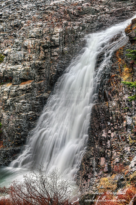
So I made the executive decision to try a different hike: Little Robinsons Valley. I have wanted to check this one out as well and it seemed like a good opportunity. It was cold and blustery and foggy and still raining when I started my hike early in the morning from Robinson Flat. Sounds like a perfect day to be out hiking. And it was. A short hike down the trail, then head off through the mud and brush towards the creek. There was lots of water everywhere. In the creek, on the trail, off the trail. The creek was running hard when I arrived. Could I get down safely to the bottom of the falls? It was surprisingly not difficult, though definitely a bit tricky because of the slick wet rocks. I was careful though, and I made it right to the base of the falls. I am very surprised (yet again) that no one seems to have known about this waterfall, especially since it is so close to Robinson Flat campground and really quite easy to get to. Of course, in the summer the creek will be dry. But right now it was awesome. There are three waterfalls here, though I would consider them all as a single tiered waterfall 109 ft. high. This final drop is 48 ft. I have more pictures of this one to come. It is an amazingly beautiful area, and there were waterfalls coming off the mountain from unnamed and unmarked side streams. It was magnificent.
As it turned out, I think New York Canyon would have been awesome after all. I suppose I should have gone there instead, but Little Robinsons Valley was pretty darn incredible too. Anyway, I have other “secret” plans for NYC later. Wink wink.
Posted in Northern Sierra, Waterfalls by leapin26: December 7, 2014

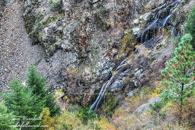
Small but pretty. That is my assessment of this waterfall in the upper reaches of American Canyon Creek. I was hoping and expecting to find a bigger waterfall here, twice the height of what I found, which was this little 14 ft. falls, so I was certainly disappointed but it is still quite a purdy thing. Getting to it, however, was incredibly difficult, but fun.
The hike started off very well. I found a trail that I did not know even existed. It followed along the creek leading almost all the way to the falls. Almost but not quite. It certainly would have been impossible to get even close to this waterfall if not for this unknown trail, which apparently horse riders know all about but not hikers. There was a lot of horse poop I had to carefully tread through. However, about a half mile downstream of the falls, the trail came to a creek crossing and then continued up and away from the creek into a private farm. There was no path continuing up the creek. I tried both sides of the creek, to no avail. It was just too brushy, and all I got was soaking wet and tired. There was only one way to go: Wade straight up the creek bed.
On went my water shoes. It started off deep, a little pool I had to wade through in which the water went up to my thighs. Not a good sign, but after this pool, there was no more really deep stuff. But there was prickly brush along the creek bed, and a few little cascades I had to climb over. Not too bad, though it would have been impossible if the creek flow was high. I felt like I was wading up the creek in the middle of the jungle, and wondering if any crocs, huge snakes, or big cats were lurking in the shadows waiting to pounce on me. In particular, I was freaked out about the latter of those three things. I made decent progress, however, until I got to the end of the road. The prickly brush all of a sudden got incredibly thick along the creek bed with no way to get through it. I could glimpse the waterfall through all that brush just ahead. If this was the beginning of the hike, I would not have even attempted this, but it was right at the end, and I could see the falls. I just “had” to trounce through this brush. My scratched up legs did not thank me later. I had to get over some prickly brush, crawl up on a big rock, then down, then up a little mini waterfall, then through more awful prickly brush, then over a very slippery log, then through more prickly brush, and finally I was in a small pool at the base of the waterfall. Whew! There was barely enough room in this little alcove to take a photo of the falls. It was a pretty little spot indeed. Just too bad the waterfall was not bit bigger. But it was fun.
Posted in Sacramento, Waterfalls by leapin26: December 3, 2014
Nine. Nine new waterfalls I have found so far this season (in the last two months). And the season has not really even begun yet (but it will very soon – our first big storm of the year is on its way). Anyway I think that is a huge accomplishment. Nine new waterfalls that most people had no idea even existed. And much more is on its way in the coming months. Of course, some waterfalls are better than others. And this one I suppose is on the lesser side of things.
At least it lived up to its name: Brushy Canyon Falls. I did not think it would. In fact, I anticipated this would be an easy hike (or fairly easy hike), and I would be able to see the waterfall from the main road. Upon Google Earth examination, it seemed the terrain was quite open, and there would be a pretty good view from the road. It was a 2 mile hike down to the supposed viewpoint, and even though you lose 1000 ft. in elevation on the road, I was up for that hike. The hike down was mostly uneventful, but when I arrived, I could see no waterfall from the road. There was much more brush than anticipated, and it was blocking all views of the waterfall. Well time to go down, then.
The problem, however, was there was a cliff in the way between me and the waterfall. It was steep, darn steep, scary steep. I did not want to go down, but I had no other choice. I descended carefully and slowly. I had to get out my rope to help me get down safely. I finally came to a little knob with this view of the waterfall. But again, there was brush and trees in the way, and a clear view of the entire waterfall was not possible. Only the top part could be seen from here. I had run out of rope by the time I got down to the knob, and it was still rather cliffy. Too cliffy to continue down any further. I may or may not have been able to get a better view further down, but there was nothing else to do but turn and go back up the mountain. Another day I suppose I will come back with more rope to try it again.
This was taken on Thanksgiving Day. Normally I like to go out hiking on Black Friday, but Thanksgiving Day is good too, and it worked out better this year to do it on TD. Surprisingly, there were a heckuva lot of cars out on the road so early in the morning. Why so many people out and about? Fortunately, I did not see anyone out on the trails. Of course, no one would have been on this trail anyway since no one knows about it. I had also thought this creek would have a lot more flow which is one of the main reasons I picked this one. But it was already on the low side, even after an inch or more of rain in the past week. Well, a lot more is on the way. Five inches perhaps, next week. Sweet galoshes. About time.
Posted in Northern Sierra, Waterfalls by leapin26: November 30, 2014
So we really have not had all that much rain yet this year. It does look like we are going to get our first really big storm next week God willing, but up to now we are actually below what we had last year at this time. We are actually a bit below average thus far; remember last year we had a very big November. The trouble last year was we didn’t get anything after that. I heard at least one news report saying that we have had more this year so far than last year at this time. Don’t believe everything you read folks, especially in the media.
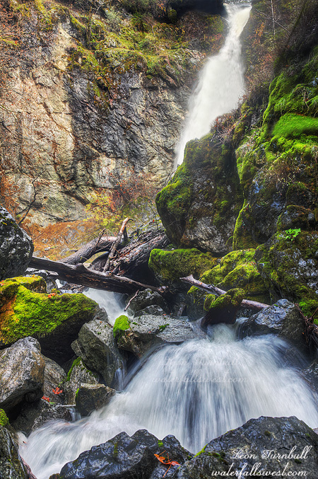
And yet this waterfall, Plummer Creek Falls, was sure roaring last weekend. It is 113 ft high and it was magnificent … but darn near impossible to get to. And as you can see from the photo I still couldn’t get a completely clear view of it.
I have wondered about this waterfall for awhile. It is clearly labeled on the USGS topo maps, but no trail leads to it, a bright spot in the midst of nothing. It seems so inaccessible. I have serious doubts if anyone has been down here before (at least not the way I went down). This one is very strenuous and quite a bit dangerous too.
After studying Google Earth I decided to try it from the south side. It is a 1200 ft. descent to the river in only a mile, however I parked further up the road, adding another 500 ft. and 1.5 miles to my hike. I suppose I could have driven this last 1.5 miles but it was a bit muddy and steep so I decided to walk it. I also started my hike late in the day (11am). The highway out here has got to be the most agonizing highway in the state. There are so many twists and turns in the road, it is impossible to drive the speed limit (55) for most of it (reminds me of a song by Sammy Haggar). It is a long long long drive. I finally got out there and started hiking down an old dirt road but it soon became impassable and too overgrown. I almost turned back. But before doing so I decided to drop off the edge of the cliff down into the canyon – er I mean hill not cliff. And I just kept going down. When I got to the edge of the cliff – er I mean hill – overlooking the waterfall, I found I could not see it from there so I just kept going down down down. Near the bottom it got extremely sketchy with large drop-offs into the river. Not good. If I fell in I would not be getting out anytime soon. Again I almost turned back. But I was almost there, the waterfall was just around the corner, I had to find a way. The terrain was far too sketchy for my tastes but I did manage to get down to the bottom finally. All in one piece.
Unfortunately, even after all this work, you can still only get a partial view of the waterfall. The bottom part is not viewable from this side and crossing was certainly not an option. There was also a lot of spray making it very difficult to take a photo. But I did the best I could. And it definitely is a glorious waterfall. I got back to my car about 30 minutes before sunset, extremely tired and with an aching back. It was a great day.
Posted in Northern CA, Waterfalls by leapin26: November 25, 2014
I had plans to go to something local this weekend right after the rain storm. However, at the last minute, my wife said she was going up north for the weekend. She did not exactly invite me, but I thought it would be a good idea to tag along, and go hiking up north for the weekend and check out some possible new waterfalls. There are tons of spots I still want to check out up that way, I just had to pick one. or two. or three. So I invited myself.
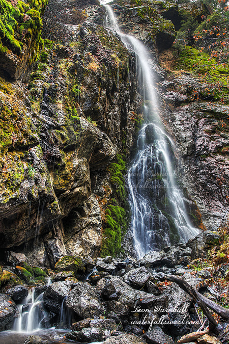
First up was this waterfall on Wells Creek. I have never heard of anyone going here before. I have never seen any photos, no one has documented this falls before, and I have never even heard anyone mention it. Even my in-laws who have lived here all their lives, and even camped in this particular area, had not ever heard of it. I wonder why that would be. That usually means it is impossible.
Well the road was sure impossible. Ok, not impossible, just ridiculous. Ridiculously slow, that is. It is a 14 mile drive on a dirt road, and it is SLOW. It is not bone-jarring awful compared to the Bowman Lake Road, but it is awful because there are so many potholes and ruts, and that means you have to drive slow, and for 14 miles of driving like that, I am a nut case by the end of it. On the plus side, there were a lot of bunny rabbits jumping out in front of my car as I drove up the road. Then a little later, there were a bunch of deer doing the same thing. Followed by a number of squirrels running across in front of me. I was waiting to come to the bear section, but I guess I never got that far. I sure drove far enough for it, you would think. The last mile or so, it did get a bit too muddy, and I decided to walk that last part. I suppose I could have driven it, but like I said I was a nut case by then, and I just had to get out and do some walking.
Finally, I got to the creek at the top of the waterfall. Wells Creek is a pretty small drainage, so I knew it would not be roaring, but after an inch of rain the night before, I figured it would be decent (ie. not dry). It probably was dry two days before this. Getting down to the bottom? Not impossible. Actually, it was fairly easy, all things considered. It is a steep descent to the bottom, but not difficult and then there is a little crook between the rocks that leads to the base of the falls. It is a gorgeous 116 ft. waterfall out in the middle of nowhere. And now you know it exists.
Posted in Northern CA, Waterfalls by leapin26: November 23, 2014
