GRACE
The Canyon Creek hike last weekend was over 14 miles with 2500 foot elevation gain. I started hiking at about 6:30AM and got back to the car at 5:30PM (not all of that time was hiking of course – I like to stop to take pictures!). It takes me two full days to recover from a huge hike like this one. No kidding. When I was young and vibrant (ha!) it probably would take a few hours to recover from a hike like this. Not any more, Theodore. After the hike, I was starving, so I stopped in Weaverville at Round Table Pizza, and ate some wings and most of a medium size pizza, then drove back to Red Bluff. Then the cramps started, as they often do on a big hike. They started in my hands. It is hard to drive when your fingers are cramped and in agony. Later that night as I tried to sleep (and “tried” is the key word), my legs started cramping badly. I could not scream out, or it would wake the kids who were sleeping right next to me. I usually don’t sleep well the night of a big hike, and this was no exception. Next day was Easter, and we went to early church service. It was a pretty busy day, and of course we had to drive back home to Sacramento as well. I had a fairly good sleep Sunday night, but Monday at work I was super tired all day long, and also felt like I still hadn’t caught up on all the calories I burned from the hike, though I kept eating constantly all day. I went to bed early again. Finally on Tuesday, my body seemed to be back to normal. Just in time to get ready for next weekend’s hike. Haha.
As of April 1, we finished this year in California at a dismal 55 percent of normal snowpack in the central Sierra Nevada, 48 percent in the north, and 40 percent in the southern Sierra. We had a very wet November and December, but then three straight months of almost nothing. This is two awful years in a row for us, and this year was perhaps even a bit worse than last year or about the same. We may get some more precipitation in April but it will not impact the snowpack much, if anything. The snow has already started melting, and we will have another very short waterfall season this year in California. The waterfalls are currently flowing well in the mountains, so if you can get out, now is definitely the time to go. It will not last.
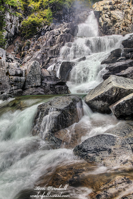
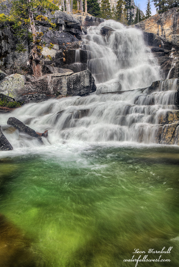
This is the Far Upper Canyon Creek Falls, often referred to (incorrectly!) as the Upper Canyon Creek Falls. If you missed the boring rendition about the naming of waterfalls on this creek, and you care, you should read my last blog entry before this one. This is probably the most popular waterfall on this trail because it is the easiest to get to. The waterfall is 65 ft. high and is a real beauty, it was my second favorite waterfall along this trail. It has real grace, splashing down in a horsetail form into a lovely little pool, changing direction and going over another little drop into another drop-dead green pool. The color in the pool was enhanced by the sun. When I arrived here, I had “light clouds” in the air, which were trying to blot out the sun, but mostly unsuccessfully. I wish I had better light when I was here, but the pool would not have been so green if it were more cloudy, so actually this photo turned out just dynamite for me. I ate my lunch here at the base of the falls, trying to gain energy for the hike back down the mountain. I still had to make stops at the three other major waterfalls on the creek on the way down.