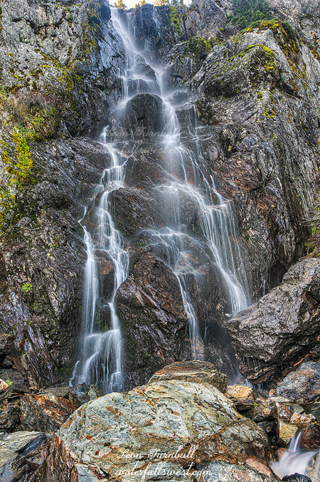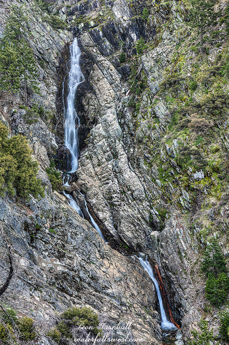
Last June I made it down to Tadpole Canyon Creek on the strangest of days. It was foggy (which is very odd for June), and indeed it was so foggy that I literally could not even see the waterfall. The fog slightly lifted for about 10 seconds and I was able to glimpse this majestic waterfall (and also take a picture). It was so nice of God to do this for me. But I vowed to return to the location this year, with no fog, and also when the waterfall would be flowing better. I did both things, but with the awful snow pack this year and all the snow melted already, the waterfall was only flowing marginally better, yes it was flowing decent, but it was not going bonkers (like it should be doing at this time of year). I guess I may need to make another trip back next year (which sure as heck BETTER be a good year).
I started the hike early from Beacroft trailhead. I had a bit of difficulty getting in there from Foresthill Rd with my little Honda. It seems that the road has gotten worse there since last year. How did that happen? The trail follows the old Iowa Hill Ditch over to Tadpole Canyon Creek. This old canal was built in 1882 but never finished. It is now quite overgrown, but you can still hike along it. There are some difficult spots including one rock slide which requires going up and around, through the middle of the burned area from the 2008 fire. I may be imagining things, but it seems the route up through here is more defined now. Have many of my followers been up that way in the past year? At the top of the ridge though, the trail becomes very indistinct again over to the creek. It seemed to me that the creek had about as much or less flow than when I was here last June. In fact, I could have sworn that I needed to get my feet wet to cross the creek last year, but this year it was an easy rock hop. This would mean bad things for the waterfall, but it seems I just had a bad memory (no surprise there). I made my way across the creek, then up the ridge on the other side, meander through manzanita brush, and finally down to the waterfall viewpoint. Now I could finally see the waterfall was flowing better. Not a lot better, but better nonetheless. And it was not foggy! I also was able to finally measure the graceful beast (186 ft. high if you care). I took my photos and packed it back up the mountain. I would have liked to explore further here, but I had things to do, places to be. My intent was to go find a second waterfall further along the Iowa Hill Ditch. I was not sure but I thought that maybe I might be able to get to it before the sun got on it. It was going to be close, so I needed to get with it and not dilly dally at Tadpole Canyon.
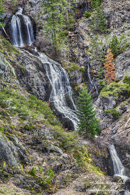
I climbed back up to the Ditch and started hiking east. It was overgrown with brush, but it was manageable. The late Russell Towle had mentioned an impassable Big Brush along here somewhere, but I never saw this. I’m not sure where he was thinking this was, but I never encountered anything that was remotely impassable. I did encounter another cliffy section, which required me to descend off trail to the bottom of the cliff, across unstable rocks, then back up to the Ditch. And continue along the Ditch. The Ditch ends at the creek. Actually it ends slightly before the creek. It looked a bit sketchy to continue from there, so I descended downhill until I could get a look at the waterfall. It was not a waterfall. I was really hoping this was a straight plunge off the cliffs, but instead it was just a series of small cascades on an unnamed creek that was not flowing very well. Certainly not worthy of mention on waterfallswest.com. But I could not see the top of it, it was hidden behind the rocks above me. I climbed back up the hill to the trail, then examined the sketchy traverse. One step was going to be a doozy, but I thought I could manage it. I came all this way, I had to at least see what the top part of this creek looked like. Hold breath. Take step. Made it across. Now I was able to make it down to the creekside easily. I still could not see behind those rocks. I crossed the creek. Looked up. Voila. Amazing waterfall found! It was a straight drop off the cliffs after all, 93 ft. high, and very very pretty. It was still in shade also, thank the Lord. Photographing this beauty, however, was going to be a big problem. It is a very steep bank on the other side of the creek, and I had to scramble up this steep bank to get a good look at the falls. There was a ledge not far up, and I shot the falls from a distance here. After this, I wondered if I could get right up to the base of the falls. I decided to try. It was crazy. Straight up the side of the mountain, very steep, slipping and sliding, and scrambling on all fours. I finally made it up to the base of the cliff and walked along it over to the waterfall and was able to get down right at the base of the falls. It was beautiful, but it was not worth all that effort! I think also the angle was too severe to photograph, but I did take some shots, and I will be posting them here very soon. Alrighty then, time to go back down the mountain. One look from the top and I said “HOLY SHUBUMBA!!!” (or something like that). I am going to die! You don’t really realize how steep something is until you look down on it from above. I carefully and slowly made my way back down the mountain, crossed the creek, over the sketchy section, and finally had my feet planted firmly back on the Iowa Hill Ditch. Whew. Now I still had to hike back to Beacroft trailhead, and I was already completely spent. I only hiked 8 miles this day, but all the scrambling up and down mountain sides totally wiped me out, especially that last one up to the base of the waterfall. Well, I had to go back though if I wanted to avoid becoming bear food. I took my time on the hike back, taking it as easy as I could. Finally got back to the car, and was starving. I did not bring my lunch because I thought this was going to be a much quicker and easier hike. I managed to hold myself together until I got back to Foresthill where I stopped to refuel (my body). Then on the drive back from Foresthill to Auburn, in one second my great morning was practically ruined, when I saw a dead bear on the side of the road. Ugh! I hate seeing dead animals, but especially bears, which are my favorite animal. There are so few of them in California too, and this seems so pointless. The dufus that hit him was most likely speeding and it is an accident easily avoided (I don’t know that but it is probably true). Argh, argh argh! Anyway, other than that one last incident I did really have a great day in the American River Canyon.