If I am going to get up super early in the morning to go hiking, I need to be motivated. Some weekends I feel more like sleeping in than getting up to go hiking. Funny that. Sometimes, it does not take much to motivate me, other times it takes a sledgehammer. This weekend was one of those sledgehammer type weekends. I did not feel much like driving a long way from home to go on a big hike, so I was initially thinking I would just go somewhere close to home, but I wasn’t really much into that either when I thought about my options for close to home hikes. As I pondered my dilemna, I thought about Deadwood Creek. I had heard of a big waterfall on this creek a couple years ago, and have been wanting to try to get to it for a long time, especially since a friend recently sent me some photos of the waterfall (actually, photos of him kayaking off the waterfall – he is one of my crazier acquaintances). It seemed to be a good time to try it. Even though it was a long drive from home, I was now motivated. The plan was set. This was on Tuesday. Now I just had to wait for the weekend to arrive!
Saturday arrived, and I was still motivated. Excited even. I got up early and started the long drive out to the trailhead. Did I say it was a long drive? Deadwood Creek is way out in the land of nowhere, many miles past Clipper Mills (if you know where that is, and you probably do not). It is about an hour drive past Marysville, well you probably have heard of that town at least. It was a freezing cold day, below 20 degrees, and as I drove past Clipper Mills, I came upon snow. Oops, I did not anticipate this. The last few miles requires driving on a dirt forestry road. With snow on the ground, would I even be able to reach the trailhead? The answer was a big fat NO. The road had obviously been driven on, however, there was a big snow patch stopping me from proceeding. If I had more clearance on my SUV I could have made it, but I did not want to risk getting stuck way out here, that would be very uncool. So … what do I do? Go home? After driving all the way out here to nowhere land, and not even able to start any hike at all? Nope. Well, I suppose I could just hike along the dirt road to the trailhead. It would be about 3 miles. So instead of a difficult 3 mile hike, I would have a difficult 9 mile hike. I had the time, and most importantly, I still had the motivation. Time to hike.
With the late start and the extra long hike, I would be getting to the waterfall much later than expected (if at all), but from my prior calculations I knew that the sun would not be hitting the waterfall until at least noon. I had loads of time. If it were otherwise, I would not even have started the hike. Photography is perhaps THE most critical part of my waterfallin’ exploits. I absolutely hate getting to a waterfall and not being able to take a good photograph of it. Sometimes it is just not possible to get to waterfalls in good lighting conditions, but I do a lot of preparation beforehand to make sure the odds are in my favor. For this one, I should certainly have lots of time but already it seemed the sun was high in the sky and shining down into the canyons. Did I make an error in my calculations?
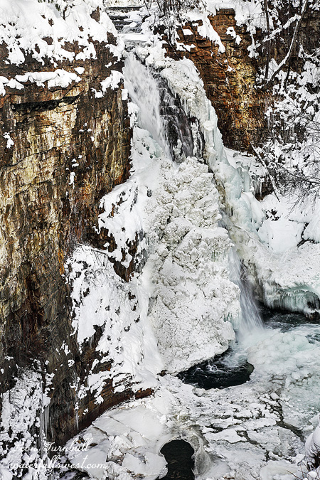
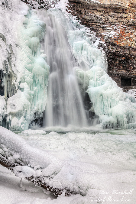
The trail down to Deadwood Creek and the North Yuba River is a dirt road, descending a whopping 1200 ft. in 1.5 miles. It was going to be a killer hike back out of the canyon. At the top of the trail I saw bear prints in the snow. Aren’t these dudes supposed to be sleeping right now? Hmmm. The hike down was fairly quick, and I saw no bears or other wildlife, except for some horrid squirrels and the thunderous quail. At the bottom of the canyon there is a powerhouse; they suck the lifeblood out of Deadwood Creek above the waterfall and siphon it down into the powerhouse along the river. Argh. Why do they need a powerhouse here? It irks me to no end. Frankly, I was not even sure there would be any flow at all in the creek. Not because of the powerhouse, but because it was so darn cold. I really thought the creek would be completely frozen. That would be just splendid. Drive all the way out here, hike all the way down to the creek, and then find no waterfall at all.
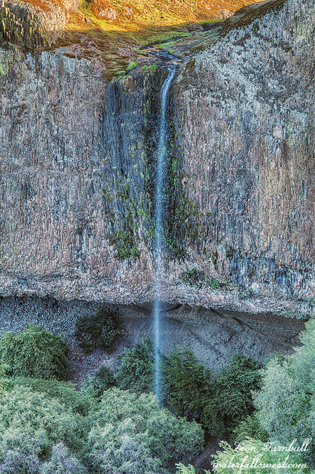
When I finally got to the bottom, I could see (happily) that I was wrong about the flow in the creek. It was flowing, and at a pretty darn good clip to boot. The last section down to the falls is steep so I used my rope to help me scale down the treacherous slope. I felt like a canyoneer. Once at the bottom, I needed to cross the creek and make my way up to the falls on the other side. Deadwood Creek Falls drops 43 ft. into a large and deep pool, and I was able to get down right in front of the falls. It was icy and cold and magnificent. And the water in the pool was just wow, such an incredibly intense blue green color. I was so happy how my photograph turned out, and how my camera portrayed this amazing scene before me. And the hike back out of the canyon? Much easier than I anticipated. I had heard horror stories about the hike up, a hike that would suck the lifeblood out of you worse than the powerhouse. Not so. It was not easy by any means, but the grade on the trail was mostly very good, with plenty of switchbacks. I have done far worse hikes than this one. It was surely a beautiful cold winter day in the North Yuba River canyon.