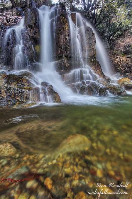
No I am not swearing. Really. The name of this creek is Jackass Creek, and the waterfall is Lower Jackass Creek Falls. Why they named the creek this, I have no idea.
I have been battling an awful cold since I returned from Canada. It has already caused me to miss a couple hiking opportunities. I still feel sick but I did not want to miss another hiking chance, so I got up early and headed out to Oroville/Highway 70. I had hopes to see at least five, perhaps eight waterfalls. I only saw three, the first being Lower Jackass Creek.
You can see this waterfall from across the North Fork Feather River along Hwy 70. I have wanted to try to get down to it for quite awhile. This was the weekend I did it. I’m not sure about the legalities of getting here, but that is another topic altogether. There was no one around. I’m sure it was fine. 🙂
It is actually a very gorgeous waterfall, 38 ft. high. A beautiful one to get right up close to. You cannot appreciate this waterfall from the other side of the river. I would have liked to spend more time here, but I had many other waterfalls to see this day. I’m sure I will be back here someday. I just hope I did not touch any poison oak down there.
Posted in Northern CA, Waterfalls by leapin26: January 6, 2013
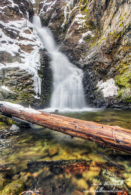
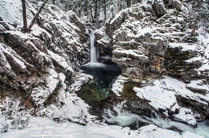
It was about two years ago I first learned of this waterfall. It is Bear Creek Falls in Trail BC, so close to civilization and the city, and yet so remote at the same time. You won’t find this one posted or documented anywhere else. It is a locals only type of waterfall, but fortunately I am in the know with the locals. At that time I examined the descent from the road. It looked very steep and especially very brushy. It did not really even look possible and I did not make an attempt. However, then my mom told me that she and dad had gone down to the waterfall about 40+ years ago. It probably was much less brushy back then but the gauntlet was thrown down. I had to get to this waterfall now. No holding back.
This winter I finally had the chance. In winter it would be easier on the one hand because the brush would be covered by snow. But on the other hand it might be much more dangerous to traverse the cliffs in the snow. There was about two feet on the ground. I did not think it would be too feasible, but it was time to make a go of it anyway. No holding back, right? How steep can it really be anyway?
You can see the falls from the road (in winter) but this is private property and not the best place to descend to the creek anyway. I started further down the road where there is a parking pullout and the terrain is easier. A bit easier. The first part, though, starts off steep right away as you need to descend into a gully and cross it. After this though it was actually quite easy. I did not bring snowshoes thinking it would be too difficult to use them on the steep terrain. So I just trudged through the two feet of snow. There seemed to be a trail I was following but I could not tell for sure under the snow cover. There were lots of animal prints too from deer and other critters. Once you get closer to the waterfall the terrain gets much more cliffy. It was not really too bad but in the snow it could be dangerous. I did not really want to slide down the mountain into the creek far below me, though it could be exciting; however the snow was very solid and I had no worries. I could not see the waterfall yet as I traversed the mountain but I could see where it would be, hidden behind the cliff ahead of me. I finally got closer and could see the falls. Now the trouble would be how to get up close to it. It was a lot more brushy close to the falls and even in winter it was very difficult making my way up to the waterfall but after crawling under a log, sliding down some icy rocks, and doing the hokey pokey, I finally made it to the bottom, getting right down to creek level at the base of the falls. It is an absolutely gorgeous 63 ft high horsetail shaped waterfall. So very beautiful in the snow and ice. Bear Creek Falls is finally bagged. Take that mom! 🙂 Now I’ll have to see about getting back to this one in the spring sometime. Oh yeah bring it on.
Posted in British Columbia, Waterfalls by leapin26: December 27, 2012
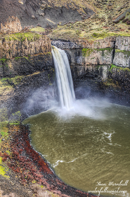
First stop on our trip to Canada for Christmas vacation: Palouse Falls in eastern Washington. Nothing really special about this photo. The light was not great when we arrived, and so I did not take much time here and I did not seek out great compositions of the waterfall. I already have some really good shots of this waterfall with amazing light, so mainly I just wanted to come here to see this 186 ft high beauty again. It is only about 20 miles out of our way on our trip to BC.
Our trip to Canada this year started out with a bang. A bang of a winter storm, I mean. Usually we would travel up I-5 through the Mt. Shasta area and then through central Oregon. However, this year our trip co-incided with a whopper of a winter storm coming through northern California. The Shasta area was forecast to receive 13 feet of snow over a 3 day period, and we would be traveling right through it. Yes I did say 13 feet! I am not sure how much they actually received, but I know the Tahoe area got about 8 feet over that same weekend. I figured I-5 would be closed for sure and it would be pointless or suicide to attempt to drive up there that weekend. I decided on an alternate route, driving through Reno NV instead. It was only about 70 miles longer, but actually it probably took the exact same amount of time to travel this route then it would to go the other way due to the conditions. The only difficult spot would be traveling over the Donner Summit on the I-80, but we did receive a bit of help from God as well, as He delayed the storm hitting the Tahoe area (just for us, I am sure).
The storm did not start to barrage the Tahoe area until Friday afternoon, though it was scheduled to start much earlier Friday morning. We got up at 2AM on Saturday morning, I checked the road conditions, and we headed out. There was chain control over I-80 as expected, but we had no troubles making it over the Donner pass with our four wheel drive vehicle. There was lots of snow to be sure, but the sailing was smooth as silver. Yet we found out later, only a few hours after we passed, they closed the I-80 for the rest of that day. If that storm had started on time as scheduled, we would not have made it through.
The rest of that day was only slightly eventful, and it did involve driving through a sand storm in eastern Oregon. I must say, I have never experienced anything like that before. My wife Tara was driving at the time, and visibility was extremely low. It was interesting to say the least, but we made it through, driving through five states that day before stopping to rest at Richland WA for the night. Order of business in Richland is always to hit Chuck E Cheese for dinner. Not my choice of course. Not my wife’s choice. I guess you can figure out who picks dinner in our family when we are in Richland WA.
The next morning we drive through eastern Washington and on up to British Columbia. It is a much shorter day, and we have time to take it easy. For my wife, that means stopping to shop in Spokane. For me, it means stopping at Palouse Falls. The weather forecast called for cloudy skies, but it was rather sunny when we arrived. We walked around the park a bit, and finally the clouds came in slightly to cover the sun somewhat, allowing me to get at least a halfway decent shot of this amazing waterfall. Ok, Leon is happy. Now let’s get to Spokane to make Tara happy as well. It was a good start to our trip.
Posted in Washington, Waterfalls by leapin26: December 27, 2012
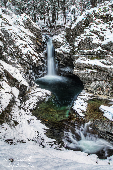
Here is one more view of North Fork Falls in the snow. Which do you like better?
We are getting a huge storm this weekend here in northern California. Up to 8 feet of snow over the weekend in the Tahoe area, up to 14 feet in the Shasta area. This storm will bombard us right through almost to Christmas Day. It is going to be crazy crazy!
Posted in Northern Sierra, Waterfalls by leapin26: December 21, 2012
This past weekend I headed up into the mountains arriving in Emigrant Gap early in the morning. There was fresh snow on the road but only a few inches, so the road was still fine to drive. My plan was not to return to North Fork Falls. However, I just could not resist. I said a couple weeks ago that I would love to shoot this waterfall in the snow. Indeed, I have been wanting to shoot this waterfall in the snow for a couple years now. The timing this weekend was just perfect. With another storm coming on Sunday, the road to North Fork Falls will be snowed in now until spring. There will be no more opportunities this year. I had to go to North Fork Falls, and it was absolutely stunning.
I parked along the road and hiked the short half mile through the snow to the waterfall. Once at the falls, there is a very steep descent down to the river. It is difficult to do this when the ground is dry, but when there is snow on the ground, it is certainly a bit dangerous. I did not intend to go all the way down to the river (like I did last time), I just wanted to go down to a certain viewpoint, which is easier to do, but still potentially treacherous with snow on the ground. I used my rope again to make the descent to be certain of no difficulties. This was actually the third time this month I had to use my rope (twice at this waterfall). Once down at the overlook, I was totally inspired by the beauty of the scene. Fresh snow all around me. It was incredible. Unfortunately, my cable release decided to stop working so I had to use my camera timer to take my photos. It worked out all right, but a cable release is so much better to use.
I was a bit longer at North Fork Falls than I intended, but figured I still had time to do the other hike. I wanted to try to get to East Fork Falls, a waterfall that is hidden in a remote canyon on the East Fork of the North Fork of the American River. I am not sure the best way to get to this waterfall, but I definitely picked the wrong route. I hiked two miles up a dirt logging road (which was not dirt because it was covered with fresh snow). It was a gorgeous hike through the snow. There were plenty of fresh animal tracks all around: deer, bobcat, coyote, squirrel, rabbit and probably some others too. These all must have been from that same morning, because it had snowed the previous day, yet I did not see any of these animals (except one squirrel). After hiking two miles, things get difficult. Somehow you need to scramble down the cliff to the river. It is about 1000 ft. straight down, very cliffy, and with the snow on the ground, potentially very dangerous. I was thinking that I would not even try it. However, I came to a clear cut area, and I could hear what may have been a waterfall or the waterfall down at the river. I thought I was too far downstream to be close enough to “the” waterfall, but there may have been “a” waterfall down there. I decided to go down through the clear cut area. It was steep, and very difficult, and I had to be extra careful because I did not want to twist my ankle again, which would have been very easy to do with all the mess from the clear cut. I made it down successfully, but I did not see any waterfall. I decided to go upstream some more, however the route got too cliffy. I realized I was still very far downstream from the waterfall, and there was no way I could make it by the cliffs. So I retreated and found a different route back up. The loggers must have cut a path down the mountain for some purpose (perhaps to get down or their equipment down more easily). It was not a trail, but it was a path that just went straight down the mountain, no messing around at all. I thought it would be easier to go back up this path. But 1000 ft. straight up in less than half a mile is brutal to say the least. By the time I finally got back to the road, I was completely wiped out. I rested on the road for quite a while before hiking back to the car (thankfully, the hike back on the road was mostly downhill, so that part was easy at least). It was a gorgeous day and I was very pleased I finally saw North Fork Falls in the snow.
Posted in Northern Sierra, Waterfalls by leapin26: December 17, 2012
