A couple days ago I wrenched my back doing yard work. Oh crikey, what lousy timing. I should just take the weekend and recover properly. That is what a normal person would do, and if it was a normal weekend, that is probably what I would do. It was not a normal weekend, though. Huge rain storms are moving through northern California this weekend. Through the end of Friday, the Sierra foothills received more than 7 inches of rain. It continued to rain on Saturday, and there is another huge storm coming in Saturday night. Of course this all means, the waterfalls are going nuts, and there is no way I could NOT go out hiking on Saturday morning, bad back and all.
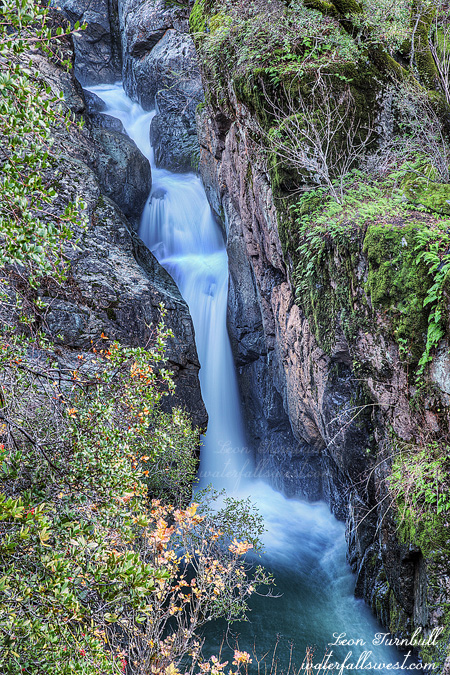
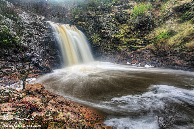
The North Fork American River gage at Lake Clementine reached over 16,000 cubic feet per second by Friday evening, more than 16 times the flow it had just that morning. This is a monster flow for this river. Why is it important? Because if the river has that much flow, then all the creeks flowing into it will also have monster flow as well, you can be sure of that. Canyon Creek is my favorite of these that flow into the North Fork. Seven significant waterfalls drop along this creek including a 134 ft. high beauty. My destination for Saturday was set.
Even though it rained all night, it was lighter rain, and the flow in the river started going back down Friday night, and by the morning it was down to 7000 cfs. This was still pretty fantastic, so I did not change my plan in the morning, though I have been wanting for quite awhile to get to this location when Canyon Creek is at monster stage. Indeed I have been waiting three years for the timing to be right. I will get there someday.
The idea was to not go down the main Canyon Creek trail. That trail would have been too dangerous in the wet weather, and I believe that the bridge is out anyway, so it would have been impossible. The idea instead, was to find a path down to a viewpoint of the biggest waterfall on Canyon Creek on the other side of the canyon. I know of a couple people that have made this trek before, so I knew it was possible.
It was raining when I woke up in the morning. And windy, very windy. These two things would make my morning rather interesting. And wet, very wet. I arrived at the trailhead without any problems, and started my hike. The first part of the hike is along old roads leading through the Gold Run diggings, and the road followed my GPS route perfectly. So far so good. The path leads over and across Indiana Ravine, and after that I needed to find a route over to the ridge I needed to scramble down to the viewpoint. Along the way I came across an old garbage can that was tipped over on the ground, with its contents strewn all along the ground. This is the middle of nowhere, why on earth would there be a garbage can here? What is worse though, is why people would throw their trash out here in the wilderness? Garbage can or not, obviously no one is going to be cleaning it up way out here. Some people need to use their brains a little more than they do. Stupid. Anyway, I picked up the can and put the garbage back in it, but it will only last until the next big wind comes along. Or the next big bear comes along (or the next little bear). I crossed Indiana Ravine and found the spot where I needed to cut over to the ridge. It got a quite a bit brushy through this part, but I made my way through and found a well trodden trail leading along the top of the ridge. I am sure this trail goes all the way back to the main Canyon Creek trail.
Now for the hard part. Getting down the ridge. I found a spot that looked promising and started scrambling down. I got down one or two hundred feet, and then it just got far too brushy to continue any further. I tried to find a way through the brush, but to no avail. I had to give up and go back. I could not believe that anyone else could have ever made it down here. It was just far too brushy. When I got back to the main trail, I was quite tired from all that scrambling, and my back was complaining. I did not want to give up, however. I decided to continue on the trail and see if I could find any other better way down the ridge. Lo and behold, after five minutes more of hiking, I came to a trail going down the ridge. A TRAIL! Not just any trail, a well trodden trail. Clearly quite a few people have been down this path before, not just one or two. I continued down the trail and although it had a couple steep parts, and poison oak scattered all about, all in all it was pretty darn easy.
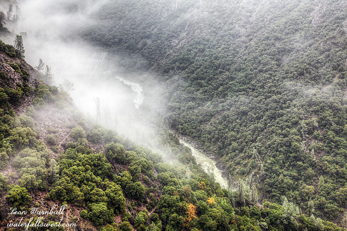
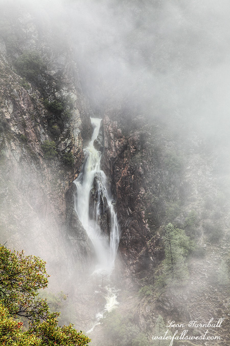
As I descended, I caught glimpses into the canyon. What do you think I saw? FOG! It was clear to me that I would get down this trail to the waterfall viewpoint, and not even be able to see the waterfall! It was also raining quite hard now as I descended. So I prayed of course: Please God, no rain. No wind. No fog. Pretty please with a cherry on top? I could hear the waterfall now, thundering down the canyon. I could hear the river, thundering below. I could not see anything. Finally, I got down the ridge. You will not believe this. The fog had disappeared, I could see the waterfall clearly. There was no wind. And just as I arrived at the tremendous viewpoint, the rain stopped. I am not fooling you. Thank you Lord, this was just really incredible.
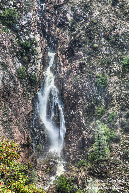
The 134 ft. high Canyon Creek Falls was thundering before me. It felt so close I could almost touch it. Yet really it was a good half mile away. The viewpoint is on some rock outcroppings on the edge of a cliff. I could see the North Fork American River off to the right, and it was magnificent. Directly below me, I could see what I think was the sixth waterfall on Canyon Creek, but the angle was severe from here for a photo of that. I quickly got out my camera and took some shots of Canyon Creek Falls before the rain thought to start up again. As I finished up, and started looking around for alternate views, the fog rolled back in. I could not see the waterfall at all! Wow. I figured that was it, so I put my camera and tripod back away, but waited around for awhile. Five minutes later, the fog rolled out and I could see the waterfall again. Alrighty then, I got my camera back out and took some more shots, and also some shots of the river as well. And then the fog rolled in yet again. This time I decided to pack it up for good, and as I did, the rain started. It rained for the entire hike back to the car. It was a crazy morning, but it was certainly an awesome one.