It was time to return to the Bay Area after the recent rain. It is always a crapshoot with the waterfalls there. Will there be enough water or not? It had not really rained all that much but I thought they should be ok. Famous last words.
It has been 20 years since I have been to this spot. I know my memory is not what it used to be but it seems to me the parking used to be better. Residents have blocked off areas in front of their houses so no one can park there anymore. This is a public park. Why isn’t there any decent parking here? It is very annoying. I arrived at sunrise and I found one and only one place to park along the road. Better than nothing, I suppose.
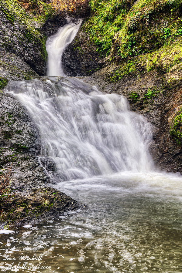
I hiked up to the lower Cascade Falls first and took photos. After this my goal was to go to the Upper Cascade Falls, which I have not been to before, and a third waterfall as well. I hoped to get to all three of these because frankly, with the horrible parking situation, I never want to return here again. Well, I could have done this, except I went the wrong way to Upper Cascade Falls. Ugh. The way I went was a good path but it was a tough climb and then a tough descent back down to the creek. Some poison oak likely touched along the way as well. I found the waterfall.
Upper Cascade Falls (aka the Inkwell, aka the Plunge), is 20 ft. high exactly (with two tiers). I had to jump across the creek for the best view with both tiers in the photo. I did not plunge into the depths of the water although the creek was flowing pretty good. There was a lot of water flowing in all the creeks and I was a bit surprised (and pleased). I’m not positive (as I said, my memory is failing), but I actually think I have been to the upper falls before but just did not realize it was Upper Cascade Falls. It is not exactly a very striking waterfall.
Since the hike to the upper falls took a lot longer than expected (because I went the wrong way), I did not have time to go to the third waterfall. I had to meet my wife and daughter for lunch. Nekoda is going back to college for her next semester so we were dropping her (and all her stuff) off at her dorm room. I will have to come back here for the other waterfall (and deal with the parking again). It was a beautiful morning in Marin County.
It is mid January now and we still have not had any big storms yet this winter. We have only had a few small storms. The snow pack is less than 50% of normal. There are still no big storms in the forecast and unfortunately, we may be going back into a dry pattern at the end of January. Ugh!
But Saturday was a rain day. I decided I wanted to go out in the rain but just an easy hike. I left Journey at home because it was so wet. She probably would have enjoyed the wetness anyway, but the rocks were slippery and a bit dangerous. I would be going to a waterfall I have not been to before. Well, I made it to the waterfall all right and it was an easy hike all right, however the creek was almost completely dry! I could not believe it. This was a good sized creek. I was not expecting greatness but I was definitely expecting decency. Darn it! Now what should I do? Go home?
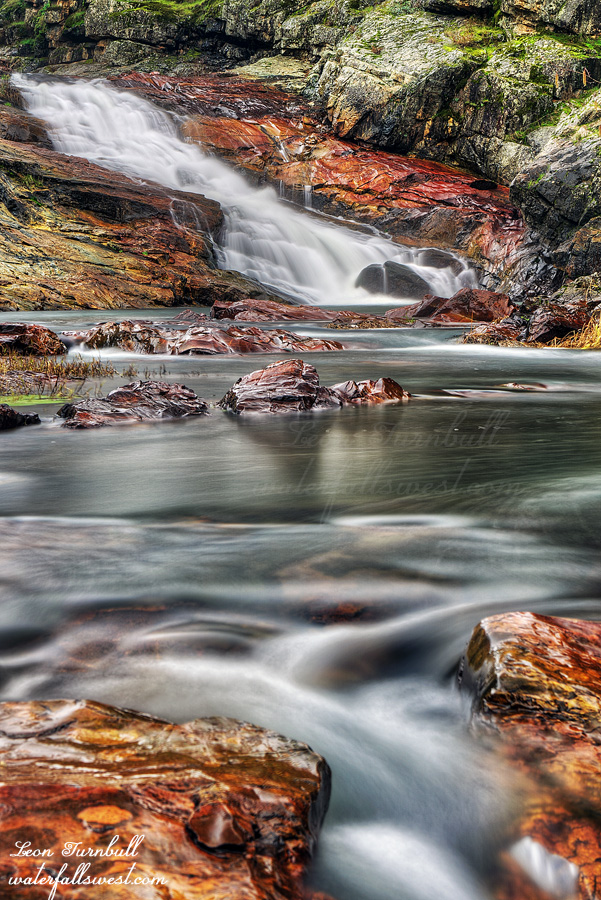
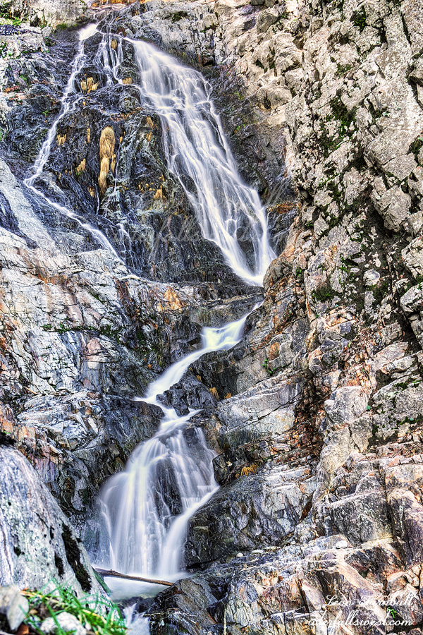
Since I was already in the area I figured I would go back to Mooney Flat Falls, which I have been to before. It is an easy hike and I knew it would be flowing a lot better than the first one. I did not want to do anything too difficult today (such as going down to the upper falls), so I just went to the lower falls. Even though it was raining the entire time, I was able to get some good photos of this 29 ft. cascade. It was a lovely rainy day out in Nevada County.
My sister has two dogs (Ebbi, Siri) and one very cute little kitten (Boh). Ebbi is a barker, as is Journey. She did not appreciate the intruder to her house. Her primary goal was to get Journey to bark louder than her. She succeeded. It was a loud house at times. Siri on the other hand was a perfect gentleman. He and Journey got along incredibly well and were best friends by the end of our visit. Boh thought he was a puppy. He followed us around when we walked the dogs on the property. Then the dogs would chase him up a tree. It was quite hilarious.
The plan was to go skiing at Fernie at least one day. Also there were a couple waterfalls in the Fernie area that I had not seen yet and I wanted to try to get to at least one of them. However, Nekoda was still quite sick and did not feel like skiing. She also did not want to drive out to Fernie to hike. (it is a fairly long drive). She thought it would be much better to do some short hikes in the Kimberley area and then everyone could go (my wife and son and dog as well). I thought this was a good idea. We returned to Cherry Creek Falls and also Marysville Falls.
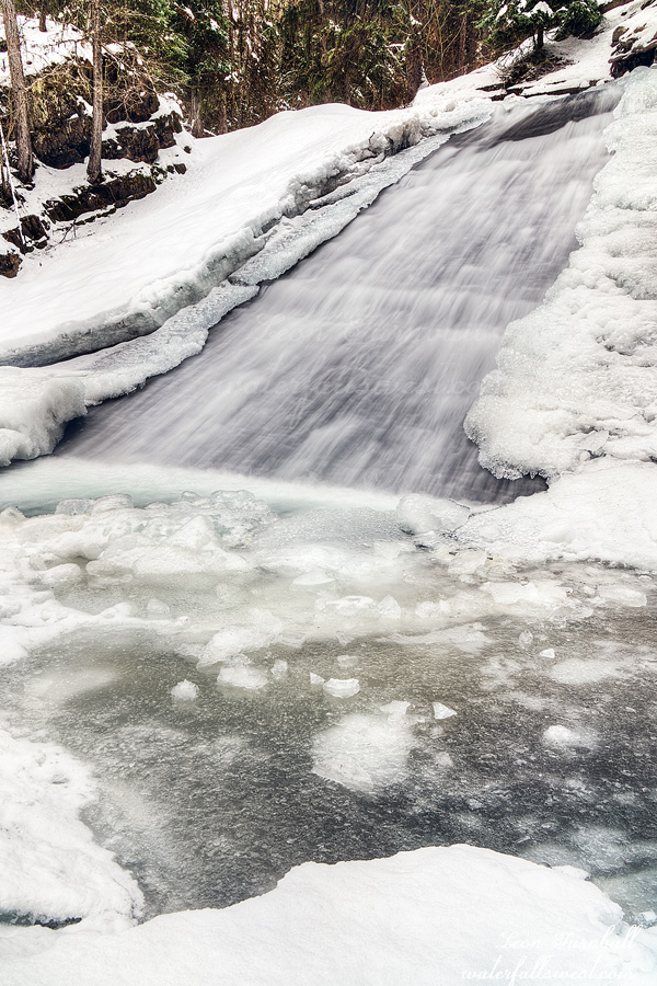
It is a short hike to Cherry Creek Falls, a very cool 30 ft. slide. I was surprised there was so much ice at the falls. (Marysville Falls as well). I was not expecting there to be so much considering the warm winter thus far but I guess Kimberley is at a little higher elevation and has been a bit colder. I got out on the ice as far as I dared to get a photo from right in front of the waterfall. Nekoda asked for permission to go right out in the middle of the ice. Do you want to die, girl? I said. She shrugged.
After this we visited Marysville Falls and then went into Cranbrook for our annual favorite Mozza burgers at A&W.
The trip back home to California was nightmarish. Nekoda got more sick and went to Urgent Care. She tested positive for strep throat. Poor girl. No one else got it, thankfully. It snowed on Saturday but Sunday was supposed to be clear. I figured the roads would be fine by then. Nope. Oregon was a mess with very icy roads. Much of the time I was going less than 50 mph. Oregon always has the worst roads in winter of any state I have been to. We made it home safely. Nekoda is better now. We had a very nice trip up to Canada to visit my family.
Our trip to Canada was delayed until New Year’s due to our sicko family all getting the COVID bug. Our daughter was still sick as we drove up north (now something other than COVID), but hoping she would recover along the way. (she did not and then our son got sick again as well – sigh).
It has been a very warm winter thus far. Usually it is a lot colder and there is more snow. I don’t remember it ever being this warm before. (I’m sure it has been, though). We did not encounter any snow until we crossed the border and then it was just a few inches on the ground. The activists will be claiming loudly it is due to global warming. Until next year comes along when it will be very cold and very snowy and then they will be quiet again. Fact: El Nino is a common cyclical occurrence that has nothing to do with global warming and these years tend to be warmer than normal (generally speaking). We have a very strong one this year.
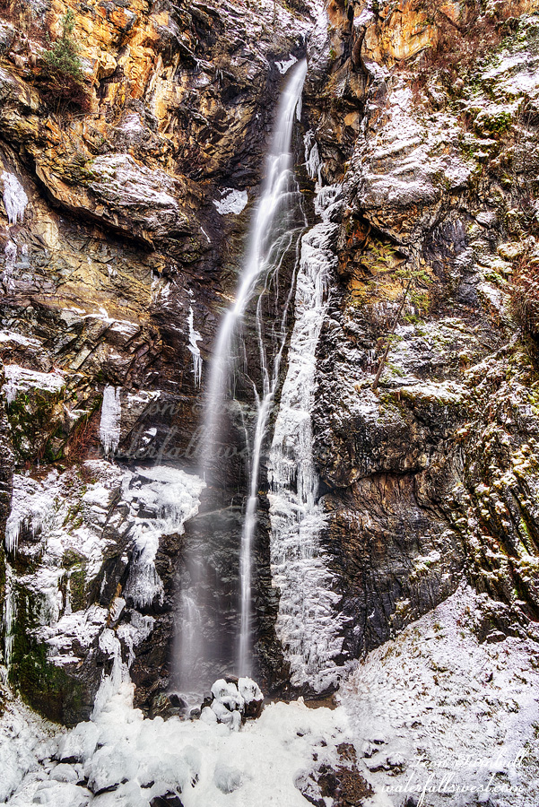
Copper Falls in Idaho is located almost right at the border (just a couple miles before it). There was maybe a couple centimeters of snow on the ground. It is a very easy hike, however my wife and son decided to stay in the car. Nekoda, Journey, and I took the short hike up to the falls. It was gorgeous. The waterfall was flowing a lot more than expected (no doubt due to the warm weather and snow melting). Copper Falls is 155 ft. high and just incredibly beautiful with the surrounding snow.
On the way back we encountered a bunch of hunting dogs off leash and howling very loud. They came right up to Journey and were all over her. They were not unfriendly but they were overwhelming her. I told the owners to call off the dogs but the dogs were not listening very well. I did not say anything to them but it really really irked me. Control your damn dogs, people. Anyhow, we had a lovely little outing in Idaho before we arrived into Canada.
Our entire family got the evil COVID as a Christmas present this year. We had to delay our trip to Canada because of it. I wasn’t happy especially because I think it could have been avoided if a certain unnamed person (not me) hadn’t gone out to see my wife when he was sick, although we probably would have gotten it somewhere else since it seems to be going rampant again.
Needless to say I was quite sick last weekend and did not hike. This weekend, however, I felt much better. I was definitely going hiking. The last hike of 2023. The last waterfall of 2023.
I tried this one a few years ago by going straight up the creek from the road. That did not work. I came fairly close and got a glimpse of the waterfall but there was no way to get up to it. My next try would be to attempt it from above, but in the meantime the Dixie Fire of 2021 raged through the area, destroying everything in its path, and in 2022 the entire canyon (along with nearby Murphy Creek) was washed out in a flood.
Now it is the end of 2023 and time to try again. On Google Earth everything looked burned out and desolate but I did not see that on my hike. In fact it didn’t really look like anything had burned. It has all grown back now, and that includes the poison oak. There was a lot of that.
I got to the creek and parked, got all my gear out, locked the car, and started my hike. Something was wrong. I could feel it. In my bones. What is wrong? I knew I forgot something. I had my water. I had my backpack. I had my hiking pole. I had my camera. Doh! I did not have my tripod! I forgot the darn tripod back at the house. Argh! The reason is because I took my wife’s car this time and did not transfer it. Normally I just leave the tripod in my car. I transferred my hiking pole but not the tripod. Darn it. What am I going to do now? Well I would figure it out once I got up to the waterfall. I probably wouldn’t make it anyway.
It was not too difficult climbing up the mountain or too brushy. The biggest problem was the poison oak. It was steep and there were a lot of loose rocks. I had to be very careful but as I approached the waterfall from near the top I could see a way down to it. It was not cliffy as I feared. I was not able to get all the way down to the creek but I made it to a fantastic viewpoint of the waterfall. Opapee Creek Falls is 103 ft. high and it is very lovely indeed. At high flows it will be spectacular. I am sure I will be back here some day. With a tripod. Thankfully there was a nice spot where I could put my backpack down and set my camera stably on it and this allowed me to take good photos of the waterfall with no tripod. Sweet.
Initially I had planned a second hike in the afternoon but decided to skip it for four reasons: (1) my trek to Opapee was so successful and also harder than I thought it would be. (2) no tripod. This was the biggest reason. I was lucky for a spot to set up the camera on my backpack but probably would not have such luck at additional spots. (3) poison oak. I needed to get home and wash up before it was too late. (4) still recovering from COVID. not really a big problem as I felt pretty good but still it was probably smart not to push it too much.
It was a great morning in Plumas National Forest with yet another new waterfall discovery.