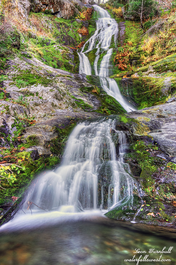
Meet Upper Bear Ranch Creek Falls, 112 ft. high. It took me four tries to get here and I was absolutely ecstatic that I finally made it.
I was in the area the prior week trying to get to this waterfall but it was an epic fail. After the Bear Fire in 2020 the brush has grown up tremendously. This route was now impassable. Before the fire I think this might have been a good route. Now, not a chance. Somehow while whacking through all the bushes I lost my Garmin Inreach. I was so mad at myself. I did not have it securely attached to my person and it fell off into the brush. I retraced my steps exactly but did not find it. Back at the top of the mountain, I had cell service so I called my wife and asked her to ping the device, which she did but there was no response. I figured it must be under some trees or logs and now is lost forever. Once I got back home I tried pinging it again. It was the same thing my wife did but this time I got a response! Now I had a location where it was and I could go back sometime and get it. But time was running out. Once it snowed I would not be able to go back until spring and snow was in the forecast for the next week. I literally had just one day to go back there, Sunday on my way home from visiting family up north for Thanksgiving weekend.
It would not be a difficult hike to go back. I figured just 6 miles round trip and 300 ft. of elevation gain. Thankfully it was not at the bottom of the canyon. I did not want to just go back to do this one hike, however. I decided to do a second hike first to another waterfall. I was not planning on Upper Bear Ranch Creek again, I was planning a different (easier) hike, but that also turned out to be far too brushy and impassable. Well …. what to do now?
I thought about taking a different route to Upper Bear Ranch Creek Falls. Perhaps it would not be as brushy. Heck, why not? I had all day. The new route was not so brushy, however, it was very steep and very cliffy. I had to be very careful in some spots. I got most of the way down the canyon and came to the top of a cliff. I thought I was done. I decided to just check out one more spot to see if it was passable and lo and behold, I was able to continue! Past the final cliff, I could forge on all the way down to the creek and to the waterfall. I was in shock that I actually made it down all the cliffs. I was in awe at the beauty of this majestic waterfall. I was so happy you have no idea. This one has been a long time in the making. I do not know of anyone else that has been here before.
I climbed back up the mountain 1700 ft. in elevation and back to my car. I was very tired but I still had a second hike to go retrieve my Garmin. Thankfully someone had cleared the fallen logs across the road and now I could drive much of it. Instead of a 6 mile hike it was more like 3 miles. I easily made it down to the area where the device was pinged. I could not see it. It was not in the exact location where it was supposed to be. I searched the area for about 20 minutes. I could not see it. Multiple passes. Praying fervently. I decided to make one last pass and then I saw it! I must have walked by it at least once without seeing the thing. I was so happy! Woo hoo! Thank you, Lord!
It was a fantastic day to see this amazing waterfall in Plumas National Forest.
I’m looking forward to seeing this waterfall. I’m sure it will be worth the $20 website fee, as I could not find it on all hikes. I live in Oroville and am really excited to check out these falls around me! Thank you!

December 5th, 2023 at 10:15 am
What a grand adventure and happy ending!
December 6th, 2023 at 6:15 am
indeed it was. thanks Mitch
March 22nd, 2024 at 3:40 pm
I’m looking forward to seeing this waterfall. I’m sure it will be worth the $20 website fee, as I could not find it on all hikes. I live in Oroville and am really excited to check out these falls around me! Thank you!
March 31st, 2024 at 7:53 am
thank you Claire. It is certainly not on Alltrails as many of the waterfalls I find are not.