DEVASTATION
I was last here five years ago but did not get to the lower falls. The lower falls is quite a bit away from the other waterfalls so I would have needed an extra day to go to it. I considered it at the time but I was just too tired. I vowed to return. Then the Creek Fire happened in 2020, which literally devastated the entire area. Many of the trails are still closed, and the Isberg and Cora trails only just re-opened this summer. It was finally time to go see the Lower North Fork San Joaquin River Falls.
It is a very long 5 hour drive to the Isberg trailhead but I was on the trail by 10AM. I expected the hike to be fairly easy and I should be at camp by 2PM. Yeah right, but it should be a good test for me. I have not backpacked in 3 months and have done very little hiking. I am still way overweight from the summer, but I have been working out a lot and I felt strong.
There were quite a few cars at the trailhead. It was surprising considering how far out of the way this trailhead is. Even so, I only saw a couple day hikers on the first day. I saw zero people on the second day.
A couple interesting things: Firstly, I noticed there was a lot of water flowing in all the creeks. When I was here 5 years ago (a wet year), they were all dry or mostly dry. I certainly was expecting them to be dry this year, indeed I was worried they would ALL be dry and I might even have problems getting water to drink from the big creek. There had been some recent rain but I honestly did not think it had rained very much here. Yet even the trail was muddy in quite a few places. They must have received more rain than I had thought.
Secondly, the devastation: it was massive. The entire canyon was scorched. I felt like I was on a barren planet. When I got off the Isberg trail onto the Cora trail I was expecting to encounter a lot of blowdowns. That was not the case, however. The trail had been completely cleared by the NFS. This was a good thing. Perhaps this is why it took so long to re-open the trails and why many trails are still closed. They don’t want to re-open them until they have cleared them. Compare to the Dixie Fire and Caldor Fire from last year. The trails there are all (mostly) re-opened already (and certainly not cleared yet). The trails in Stanislaus NF could be closed many more years if they are going to wait until they are all cleared. I don’t think that is a good thing, but at least they are actively working on clearing them. Unlike at Yosemite National Park, where they have let the trails go to rot after a fire many years ago. (I’m still upset about that – if you can’t tell – ugh).
It was much harder getting down to the river than I expected. I really thought it was going to be a cakewalk except for maybe one small section. It was difficult and steep and rocky and brushy. I made it down to the river at 3PM, one hour longer than anticipated. I found a nice spot to camp at the top of the waterfall, made my dinner, then went down to see the falls afterwards.
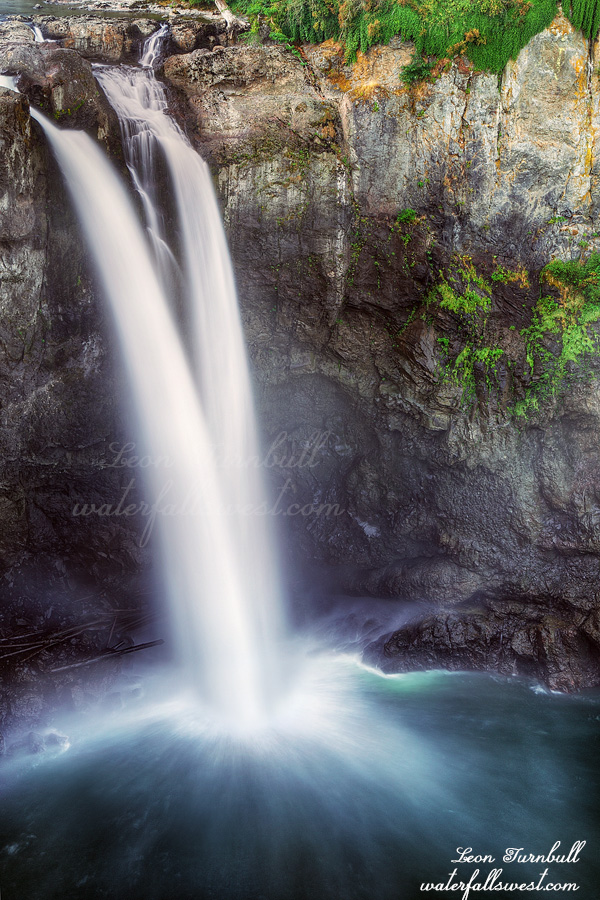
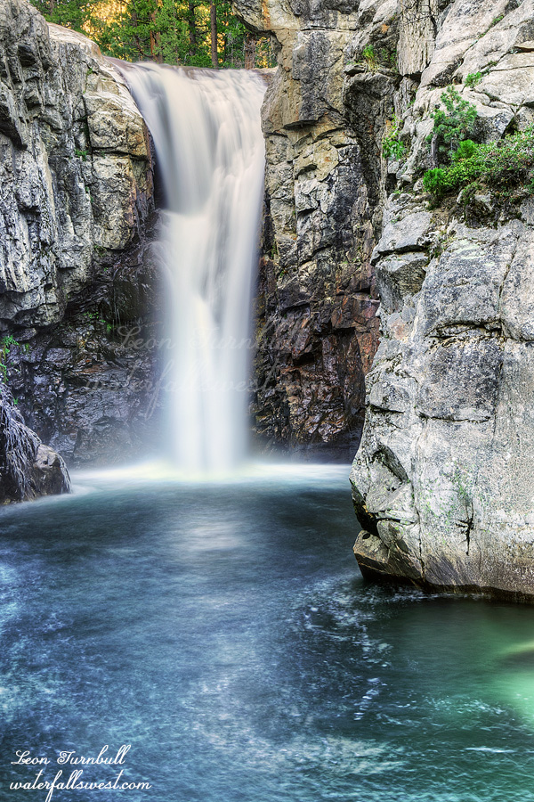
Lower North Fork San Joaquin River Falls is a gorgeous 51 ft. high plunge into a big, beautiful, magnificent pool. It is a stunning oasis in the middle of the devastated canyon and well worth seeing. I took many photos and enjoyed the waterfall immensely.
I returned to camp. It was still early so I relaxed on the rocks by the river (where there were no gnats). After I was attacked by a water spider, I decided to retreat to my tent and then watched a movie before bed. It was a warm night and I slept fairly well beside the sound of the rushing river.
I got up early, made my breakfast and coffee, and was on the trail by 7:30am. I found an easier way back out of the canyon, which saved a bit of time (well, slightly easier – it was still a tough 2000 ft. climb). I was back at my vehicle by 12PM, and home by 5PM. It was a fantastic, short weekend in Ansel Adams Wilderness.
2 Comments