One day. Just one day. Out of all the days on our trip, I just wanted this one day to be a nice one. And what was the forecast for this one day? Rain all afternoon. And quite a lot of rain to boot. Ugh.
Our boat tour started at 4PM. Our family were the only ones on the boat (nine of us, plus the boat driver). We were also the only ones at the waterfall. I think most people take a morning tour but we specifically asked for an evening tour so the waterfalls would all be in good lighting conditions. Of course with the rain, that point was all moot. But still, we did not know it would rain when we booked it! And it was cool having the tour all to ourselves. Such an incredibly beautiful place and no one else is around. How awesome is that?
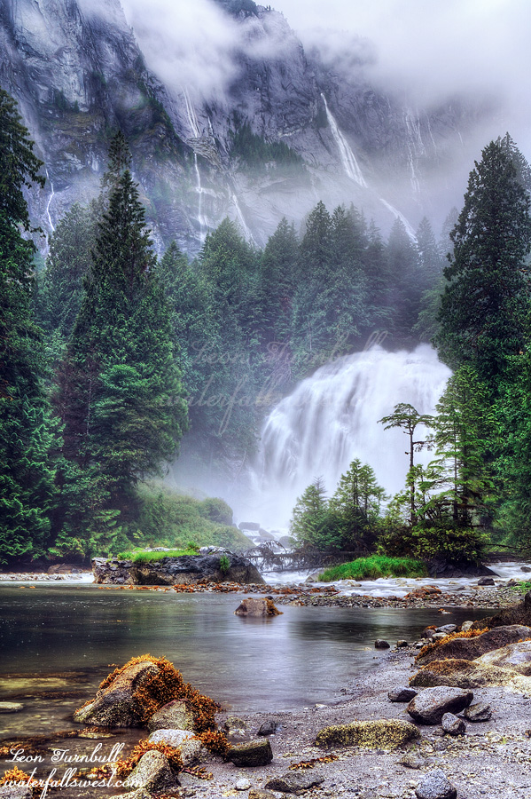
Princess Louisa Inlet is often hailed as being THE most beautiful inlet in the ENTIRE world. It would have been nice to see the mountains and the glaciers on the one day we went there. Even though we could not see that part of it, I still agree with that assessment. The waterfalls dropping into this inlet are simply out of this world. It is Rivendell. It is majestic. It is stunning. It is magnificent. You cannot count all the waterfalls. I can try. No I cannot. There are perhaps 8 major ones and many others as well. Thanks to La Nina they were all flowing fantastic even in August. This is literally Heaven on Earth.
Chatterbox Falls is the main attraction of the day, an absolutely spectacular 70 ft. high waterfall on a major creek dropping into the end of the inlet. It was roaring. You cannot get anywhere close to it without getting completely soaked. The only way to photograph it is from way back along the shoreline. It was raining pretty hard, making the photography very difficult. I stood on a rock by the shoreline waiting for the rain to subside a bit and enjoying the immense views. As I waited, the tide started coming in. Before long I found I was stranded on the rock with water all around me. Wait, what just happened? I jumped off the rock back onto the shoreline, moving my backpack further away from the incoming water. I took my photos now from the shoreline, not on the rock. Chatterbox Falls is not the only attraction here. How about the tallest waterfall in all of North America? That’s right folks. James Bruce Falls streams down the mountain in an incredible 2755 ft. high cascade above Chatterbox. It is even bigger than Yosemite Falls. You can see it partially in this photo. I should have some better photos of it also. I would have loved to have hiked up above Chatterbox Falls and closer to it but there was no time. The tour only gave us an hour at the falls, not nearly enough time to hike up there. Plus the rain made it worse. I spent the entire time trying to photograph Chatterbox Falls. I was not even sure that I had one decent photo of the waterfall by the end of it. I was soaking wet and when I got back to the boat everyone was waiting for me. But it was all good and fun. What an incredible day at an incredible place. Princess Louisa Inlet and Chatterbox Falls.
Posted in British Columbia, Waterfalls by leapin26: August 14, 2022
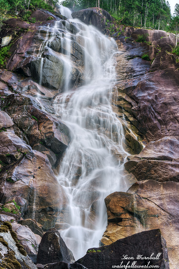
We got up early and drove down the road a short distance to magnificent Shannon Falls. When we drove past here the previous afternoon the park was completely packed. But this morning at sunrise? We were the only ones here. Actually, by the time we were done, quite a few more people had arrived. It was getting busy already, even so early on a weekday morning. This must be a popular waterfall! At least there was no one at the viewpoint when we first arrived. We had it all to ourselves for a short time.
Shannon Falls is indeed spectacular and right beside the highway (no wonder it is popular!) The total height of the falls is about 800 ft. high (only the bottom 495 ft. is visible from the base of the waterfall). After checking out the main viewpoint I went up the trail to find a way to get closer to it. I could not talk any of my family into coming with me. They just wanted to lounge about at the viewpoint. How boring. It was actually fairly easy to get right up to the base of the falls though slightly tricky on the big slippery rocks. As I was taking photos I could hear hollers and whoops from people that were up at the top of it (I could not see them). I assume it must be a pretty darn good view from up there. Why else would they be whooping so much? If I had more time I would have gone up to the top myself but we had a ferry to catch.
We arrived at the ferry terminal 1.5 hours before the sailing and barely made it on the boat. A lot of other people were traveling to the Sunshine Coast. I’m very glad we did not have to wait until the next sailing. That would have sucked.
On the other side we had lunch at Gibsons. At A&W again! More mozza burgers! Yumm! It is sure a good thing the rest of my family also likes A&W. Ha ha! After lunch we drove to Sechelt where we would meet up with my family. From there we all drove to Egmont where we would staying for two nights. It is a very pretty little place beside the harbor. We each had our own little cabin which was small but quite quaint. The only bad thing about it is that the bar closed very early each night. My brother in law was not happy about that. Ha ha! Also, apparently the guy in the cabin next to us played in the NHL, as my wife overheard. I did not recognize him so I decided not to bother him, I figured he must have been a fringe player. I would have felt bad if I had gone up to him and asked his name, and then did not recognize the name. Who are you? Oh that’s nice. I never heard of you!
It was a great day 2 on the Sunshine Coast. The next day would certainly be glorious. Right?
Posted in British Columbia, Waterfalls by leapin26: August 11, 2022
Our family trip to Desolation Sound in beautiful British Columbia, Canada, was a long time in the making. My mom planned and arranged this for our families (her, my family, and my sister’s family) way back in 2020. Of course we all know what happened that year. We tried again in 2021 but travel was still prohibited for us to Canada. Finally in 2022 we were all set to go. BC or bust! We all tested negative darnit! We were all going to Canada darnit! We were all excited darnit! But alas, sadly, it still did not work out perfectly well for all of us (stay tuned for Day 4 to find out why).
My mom did most of the planning for this trip. I was just along for the ride. So that means this was not primarily a waterfall trip. It was primarily a family vacation and ocean trip. Nonetheless, I still managed to see and photograph about 20 (or more) incredible waterfalls on this vacation. BC is so amazing!
One thing I did plan myself was the first day (before we met up with the rest of the family the next day on the Sunshine Coast). We stayed the first night in Squamish BC where there were 5 awesome waterfalls I wanted to see in Squamish and Whistler that I had not seen before.
We arrived at Squamish early and hung around town a bit before we could check into our hotel. We found out (too late) that the hotel we booked has a bar below the rooms and they play loud music until 2AM! THANKFULLY, we came on a Monday and they do not do this on Mondays. (big sigh of relief). We checked in and then went to A&W for dinner where I got my annual mozza burger fix. Mozza burgers are my absolute favorite! They don’t have these in USA so whenever I go to Canada we MUST go to A&W! It is not optional. After dinner we drove up to Whistler to check out 4 of the waterfalls.
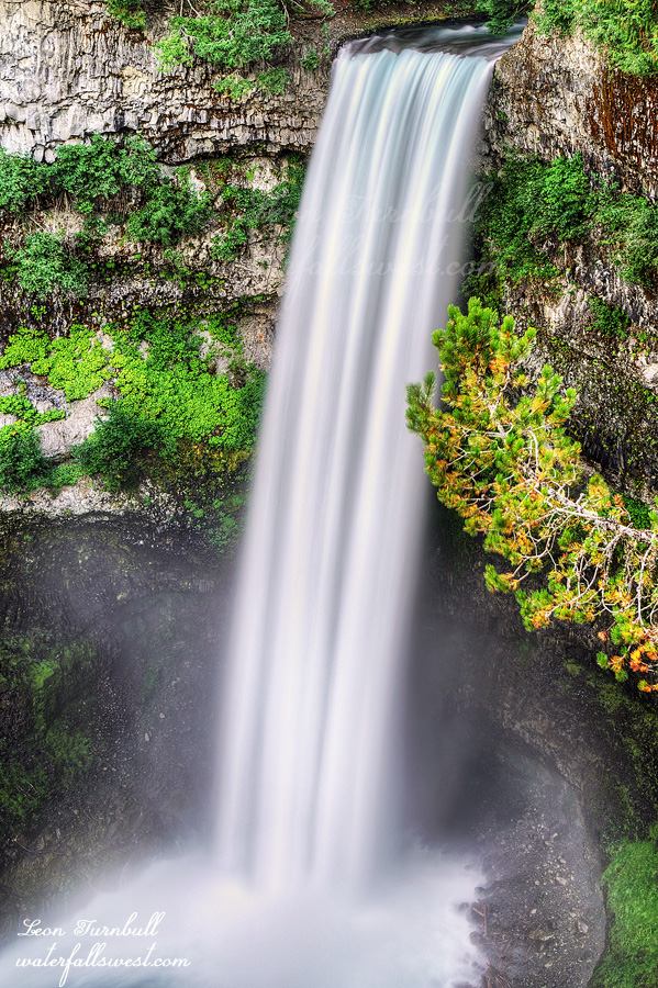
The last one we went to: incredibly beautiful Brandywine Falls. I measured it to be 171 ft. high though it is officially cited by the park as being 230 ft. high (not even close). We arrived at the park just before sunset. Supposedly they close the gates at sunset so we had very little time to walk down to the viewpoint. My son Jadon stayed in the car while Tara and Nekoda and myself quickly walked to the viewpoint. It is a very easy walk. Brandywine Falls was flowing very beautifully! It is absolutely gorgeous and arguably the prettiest waterfall in all of British Columbia. I have wanted to see this one for a very long time. Even though it is August all the waterfalls in British Columbia were flowing very well. A drought for California does not mean the same for BC. Thanks to La Nina, BC had an above average winter and spring. We picked the perfect year to come up here to see waterfalls in August. Sweet goodness gracious!
We did not get locked in by the park rangers even though it was a bit past sunset when we got back to the car. Whew, that was a close one. We returned to our hotel in Squamish and had a good sleep with no loud music to keep us awake. It was an awesome first day on the west coast of British Columbia.
Posted in British Columbia, Waterfalls by leapin26: August 9, 2022
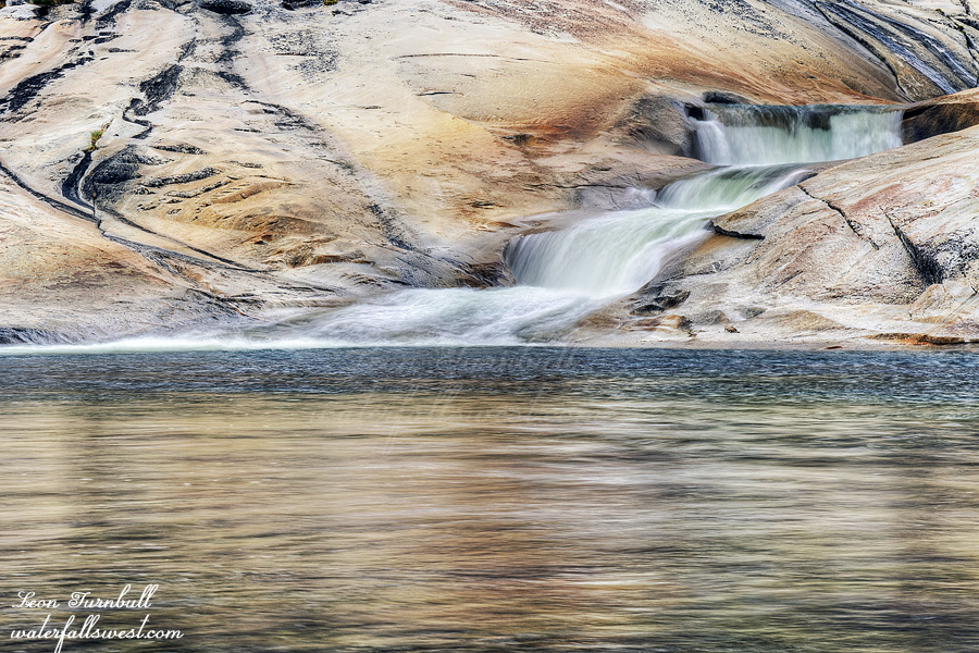
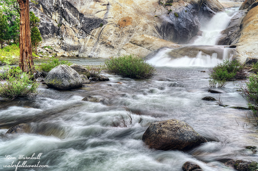
This is Middle Cherry Creek Falls, 36 ft. high. Where I camped for the night. A very beautiful place!
Posted in Northern Sierra, Waterfalls by leapin26: June 14, 2022
It rained most of the night. It was still raining when I got up and continued to rain throughout the morning. So what did the weather forecasters say about this? TWENTY percent chance of showers on Sunday. I think one site might have said 40 percent chance of showers but the others said nothing like that at all. WHAT AN EPIC FAIL. Showers is one thing. I expected I might have a little bit of off and on showers and so I did bring my rain jacket. This was constant rain all night and morning. Light rain. But still rain nonetheless. Not showers. I did not bring my rain pants or my gloves. I dearly wished I had brought these two items. If I had then the hike back out would have been much more pleasant in the light rain. Instead it was miserable. You can call me an idiot for not being prepared enough, I don’t mind. I should have known better. It is a 1500 ft. climb out of the canyon with no trail and a lot of brush. The brush was wet from all the rain and so I was a soaking dog long before I finally got to the top and back on the trail.
I was extremely happy that I saw all the waterfalls on the previous day. I certainly would not have wanted to go to any of the falls in the morning in the rain. I ate my breakfast and drank my coffee hiding under a tree sheltered from the elements. The photo shown here is Lower Cherry Creek Falls, 51 ft. high.
Once back on the trail at the top of the ridge it is a 4 mile hike back to the car. Unfortunately there is still a lot of brush overgrowing onto the trail. It is not a problem if the brush is dry but of course it was not dry. It was also still raining. It was too miserable to stop so I hiked the entire 4 miles without stopping. It is all downhill though so that was good. I got back to my car and turned up the heat to warm myself up. I drove straight home. I did not stop for pizza this time but I did get a triple western burger at Carls when I got back. It was a good trip down into the Cherry Bomb gorge in the amazing Emigrant Wilderness.
Posted in Northern Sierra, Waterfalls by leapin26: June 8, 2022
