This would likely be my last backpacking trip before Fall (though I may possibly do one more in June). I had this trip on my list for this spring but I did not think I’d get to it. I did not really want to drive back out to Yosemite for a third time this spring (it is not Yosemite actually, it is Emigrant Wilderness which is just before Yosemite but essentially the same amount of driving). However, rain was in the forecast for the weekend. Quite a bit of rain. But for the Yosemite area there was no rain in the forecast or very little anyway so going back to this area seemed like the best bet for the weekend. Yeah right. More on this in part 2.
It was Saturday. It was raining on Saturday. What did the forecast say? ZERO PERCENT chance of rain on Saturday. I don’t know about you but to me ZERO means ZERO. Nada. Nothing. Zip. No possibility of any rain whatsoever. If the stupid weather forecasters have any doubts why don’t they say 10 percent. Zero means NOTHING! Anyway, it was not raining very much but I did need to get out my rain jacket. I did bring my rain jacket but I did not bring much else. It was only a 20 percent chance for Sunday after all. Again, more on this in part 2. (it’ll be a good one)
There were a lot of cars at the trailhead including one that I was pretty sure belonged to kayakers. Cherry Creek is a popular run for expert kayakers but I thought it was a bit late in the year for them to be doing this run. Well I hoped that no one would be camping down in the canyon where I was going. I suppose it was unlikely because there is no trail and it is very difficult. Still it was possible.
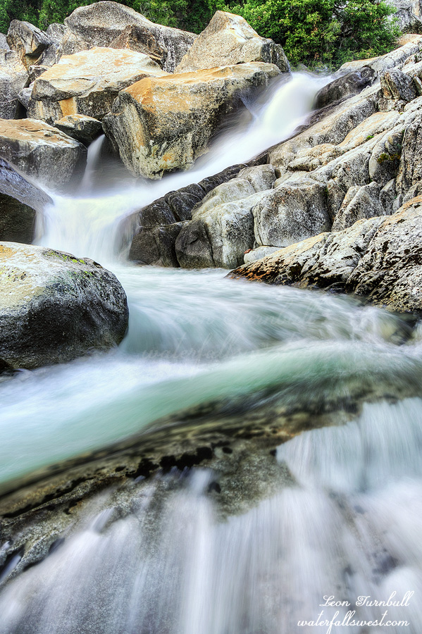
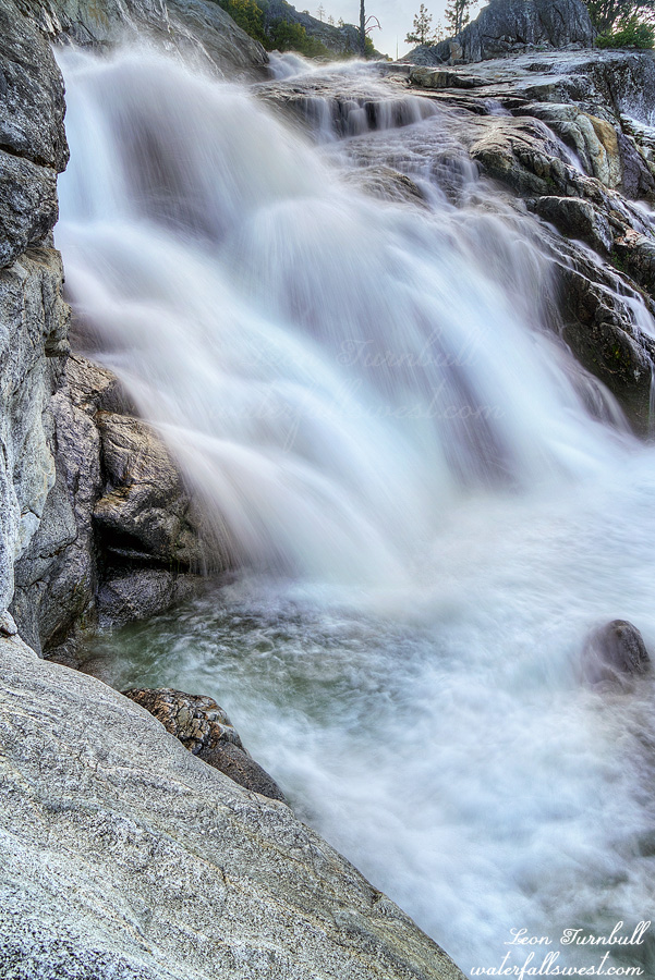
After you climb up to the top of the ridge on the trail you need to go off trail down into the canyon. No trail. Very brushy. It was a lot harder than I remembered. I made it down to camp by 2PM. There was no one else down here. Fantastic. I had the entire place to myself right beside the Middle Falls. It is a gorgeous campsite and a very large sandy beach like area to put up my tent. There were very few mosquitoes at this spot. It was perfect!
Thankfully it was a cloudy day. It was also still very early. My plan and hope was to go to all four waterfalls today. That way I could sleep in a bit and not have to go to any of them in the morning.
When I was last down in this canyon I failed to make it to Cherry Bomb Falls. My planned route turned out to be much too steep and I could not figure out a way to get up above the cliffs at the Middle Falls for the life of me. So what do you do when you fail the first time? Give up! No! The madman does not give up but when it comes to waterfalls he certainly may need multiple attempts before success is found.
I had a different route this time and a better one. I was able to make it above the cliffs without much difficulty. Once you get above the Middle Falls the scenery is absolutely outstanding. Wide open granite. It is an easy walk over to the edge where you can look down into the Cherry Bomb gorge.
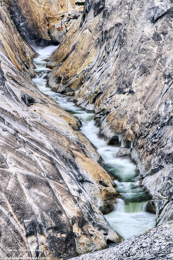
Maybe only kayakers will appreciate this view. Cherry Bomb Falls is not really much of a waterfall. It has a 20 ft. drop at the top and then it continues into a long cascade in a very tight and steep gorge. Of course I knew this beforehand but I still wanted to come here. It was certainly worth it! I really loved this spot and this beautiful cascade. The scenery is incredibly magnificent!
Now it was onto the next three waterfalls, the last one being the Middle Falls at my campsite. When I finally got back to my camp I found that I had company. The kayakers had made their appearance. I missed seeing them go over the waterfall as they had already done that and set up their camp. Thankfully they were camping on the other side of the river. I don’t know if they planned to do that anyway or they saw my tent and decided to go on the other side to give me space. Either way I am grateful because they had a large group and if they were camping right beside me they would have been invading my space and been too loud and keeping me awake in the night. I was so glad to have my peace and quiet at my campsite on the beautiful sandy beach. Part 2 is on the way.
Posted in Northern CA, Waterfalls by leapin26: June 6, 2022
My planned hike was a very difficult one mostly all off trail and over 4000 ft. elevation gain. I had no room to spare and only two nights available because I had to get back home for a few important things (one of which was my anniversary – not much wiggle room for that one). However, it took much longer to reach Laurel Lake than anticipated. I did not think I’d be able to make up any of that time on the rest of the hike (from Laurel Lake it gets harder not easier).
The further I descended down into the canyon the more I realized I would not make my intended destination to the big waterfalls. I would be hard pressed to make it to the first of the waterfalls. I really needed two more days for this hike than I had planned but I did not have any more days. The canyon is absolutely stunning. It reminded me of West Cherry Canyon but it is much more difficult. There is quite a bit of brush to negotiate with some (but less of) the fantastic open granite spaces yet still the canyon walls are incredible all around you.
I came to a place where I could not continue. At least not very easily. By this point I was incredibly tired, it was getting late, and there were still three more hours before I would even reach the first of the waterfalls. Even if I could make it that far it seemed pointless to continue because I could not make it where I really wanted to anyway. As I said I needed a couple more days which I did not have. I decided to retreat.
I came to this small waterfall on Eleanor Creek and found a place to camp. It was actually an incredibly pretty little waterfall about 20 ft. high and definitely a worthy one. I call it Far Upper Eleanor Creek Falls. I enjoyed my camp here with the tiny lizards. They were about 2 inches long and scampered about, jumping behind the rocks when I came too close to them. They were hilarious.
I don’t ever sleep in but sometimes I would like to. I was up at 6AM. Sigh. I packed up, had my breakfast and coffee, and started my journey back home. I still had a long way to hike back to the car. It took 9 hours to get this far and I anticipated the same back.
If you know exactly where to go that does save some time and I got back to Laurel Lake an hour ahead of schedule. From there it would be all on trail and mostly downhill. I would not go back down the Frog Creek canyon. I was done with all the off trail anguish for this trip. That means I would have to cross Frog Creek at a different place. The creek was flowing “somewhat” gently at the crossing but it was deep and I realized that this crossing would probably be up to my waist level. All my electronics hang around at about waist level so I took off my pack and moved them all up to a higher safer place. The creek was very cold but only up to my mid thigh. (that is pretty darn deep though).
It is 8 miles from Laurel Lake back to my car. The last 4 miles from Miguel Meadow to Lake Eleanor are along a very old overgrown road (now a trail). The section along this old road I found to be very interesting and there were also tons of butterflies. Back at Lake Eleanor I found the trail crew still there. Two days later and they still had not started doing any trail work. Maybe they weren’t actually a trail crew after all. They were all hanging out in a circle and blindfolded. I walked right past them and they did not even see me. Is this some kind of training for being a trail crew? or maybe fire fighting? or maybe none of the above? I don’t know. All I know is that the Cottonwood Creek trail at Hetch Hetchy still desperately needs to be cleared. I got back to my car and drove to Pizza Factory in Groveland (of course). It was another beautiful and amazing trip to Yosemite National Park.
Posted in Waterfalls, Yosemite by leapin26: June 1, 2022
I left work a bit early on Wednesday afternoon and took off. Back to Yosemite again! I picked up my permit and drove straight to the Lake Eleanor trailhead. It was 6:30pm. My plan was to hike in 3 miles to Frog Creek and camp for my first night. The next day the fun would begin (I hoped).
Surprisingly there were quite a few cars at the trailhead. I was not expecting to see anyone here in the middle of the week. I have been here a few times before and never seen anyone at all.
There were also a large number of cars on the other side of the dam and a whole bunch of people sitting around a campfire. It seemed they were a trail crew getting ready to start out to work the next day. But were they? (come back for part 2)
I passed them by and continued on my journey to Frog Creek arriving just after sunset. I walked straight to the creek to look at it. The weather has been extremely warm and the river flows have jumped up significantly. The Tuolumne River had tripled in flow up to 1670 cfs on 5/19 (and 1780 cfs on 5/20). One last gasp of snow melt before the summer starts. I was 80% sure that Frog Creek would not be crossable and my trip would be a bust (though I did have a Plan B). I took a look at the creek and well … it was flowing strong but it did seem crossable. I think I was going to be ok for my next day after all.
I backtracked to find a place to setup my tent. There was another couple camping here. They had all their stuff spread out and had pretty much taken up three places to camp. I suppose they were not expecting anyone else to show up but still … Anyhow I found a good spot. By now it was dark so I setup my tent and went into bed. In case you are wondering, yes there are frogs here at Frog Creek. I think they were more around the lake than at the creek but I’m sure there were some along the creek as well. I fell asleep to the sound of them again. My wife says she knows what frogs talk about to each other all night long: they talk mostly about what “bugs” them. Sigh.
I got up early, packed up, and quietly walked past the sleeping couple to the creek crossing. It was up to my knees and cold but otherwise not too bad.
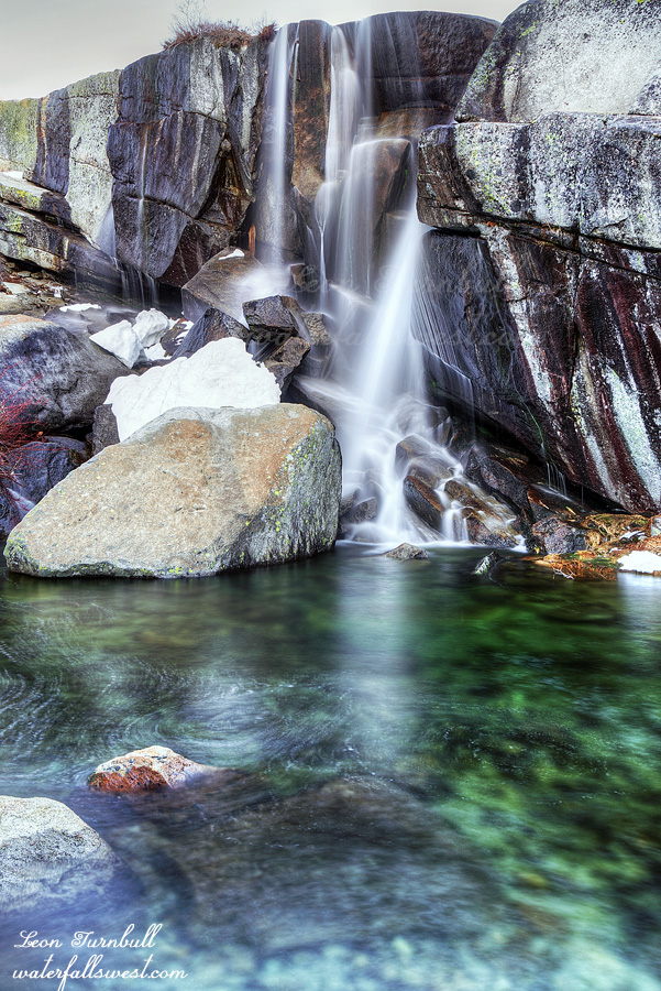
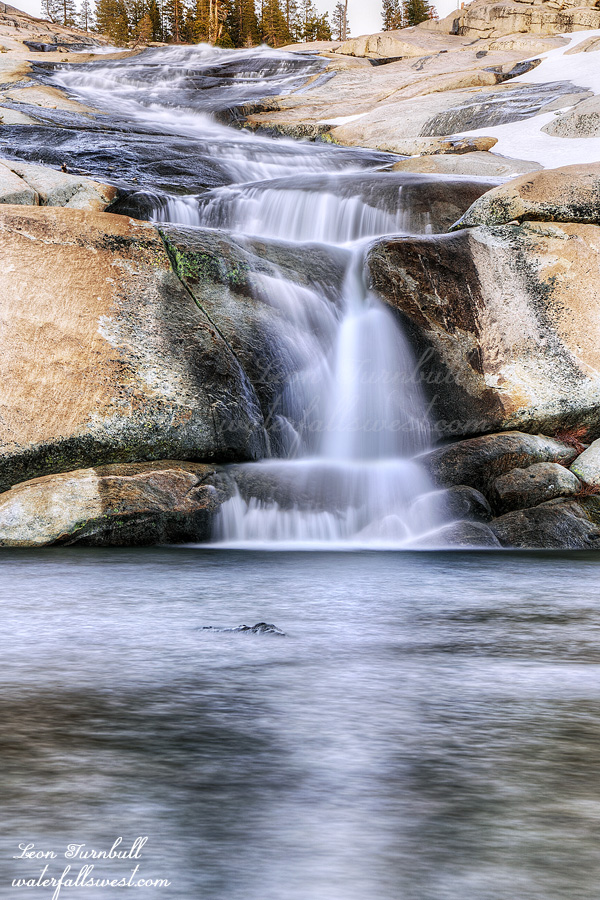
You may wonder what I was doing crossing Frog Creek here. There is no trail on the other side of it. My plan was to climb up the Frog Creek canyon all the way to Laurel Lake (and beyond). I have done this before but just to the lower Frog Creek Falls. There is a middle and upper falls as well (the middle falls is pictured here). Frankly, I don’t know how I missed this one before because it is immediately above the lower falls and is a heckuva lot nicer than the lower falls (it is about 40 ft. high). There was a lot of mist so it was difficult to photograph but I was able to get some shots. I had my breakfast here before continuing up the canyon to the upper falls and then all the way up to Laurel Lake. It took a long time to get to Laurel Lake and I arrived about 2.5 hours later than I had planned. This was not a good thing at all.
Part 2 is coming …
Posted in Waterfalls, Yosemite by leapin26: May 30, 2022
My sleeping bag zipper busted in the middle of the night. Toasted. Kaput. The temperature was less than 40 degrees and I had no sleeping bag. Well thankfully I had my sleeping bag liner with me and I put the useless sleeping bag over me like a blanket so I was not cold. Now for my trip next week I am going to have to use my summer sleeping bag (hint: it is not summer).
I wanted to sleep in a bit but I was awake at 6AM anyway. I made breakfast and coffee, took some more photos of the waterfall and was on the trail by 7:15AM.
I did not see any animals on this trip but I did see quite a few animal tracks in the snow: bear, coyote, and some absolutely huge cat prints that could only be from a mountain lion. All the tracks were fresh. So where did that mountain lion go? He is probably watching me from somewhere close by. Hmmm …. lunch time …
On the road back to where I was parked I came across an interesting sight: a big truck was stuck in the snow. You would not think that someone with such a big truck could get stuck but there it was. They had already tried pushing it out to no avail so I could be of no help to him but thankfully his friend was already on his way to rescue him. I continued on my merry way and arrived back at my car a short while later. Maybe it was a good thing I did not attempt to get past that snow patch the previous day. It was a fabulous couple days in the Desolation Wilderness.
Posted in Northern Sierra, Waterfalls by leapin26: May 26, 2022
I have been to Crystal Basin Falls before but I always wanted to return at peak flow in spring and camp here as well. I envisioned it being very spectacular in spring. I put it on my list to do this year.
The timing for my vision was critical and after checking the snow maps and satellite images I thought this weekend might be one or two weeks too early. However, the next couple weeks would not be possible for me so I decided to go now. There would likely still be a lot of snow here but it still should be good.
The road to Wrights Lake on Highway 50 was still closed and gated (at least, that is what the website indicated) so my idea was to go from Ice House Reservoir. It is 10 miles to Wrights Lake from there and there would be snow but I figured I would drive as far as possible and hike the rest of the way. I hoped to drive at least 3 miles on the road. I drove 5 miles before I hit the first snow bump on the road and decided to park here. I think I could have driven a little further but I wanted to get in a decent hike. It would be 5 miles on the road plus 3 miles on the trail to Crystal Basin Falls. It would be a fairly easy hike which I certainly needed after the huge one I did in Yosemite last week.
Wrights Lake was closed in the summer for the Caldor Fire which raged through here. You might expect the entire lake to be burned but in fact there was no burn through this area at all. It was as beautiful as always. That is a good thing for sure. I did see badly burned areas along the American River canyon (highway 50) but nothing in Ice House or Wrights Lake area.
I reached the trailhead for the Rockbound Trail. This is where I expected things to get very difficult with the trail being very snowy and very muddy. Instead I found the trail to be almost all clear and very easy. This was shocking. The snow must have all melted off in just one week. Now I am thinking I was not 1 or 2 weeks too early but perhaps 1 week too late.
I arrived easily at Crystal Basin Falls at about 12:30PM. The waterfall was nice for sure but definitely not what I had envisioned. Even if I had been 1 week earlier I don’t think it would have made much difference. I now think I probably need to come back during an above average year at peak flow. Anyhow I setup my tent right next to the waterfall and relaxed for the rest of the afternoon. It was an incredibly beautiful spot.
In the evening I decided to hike up to Twin Lakes. Normally I would hike on the south side of the creek but the creek was too high to cross without getting very wet and there was quite a bit of snow on that side so I tried the north side of the creek instead. It was a little difficult getting up above the waterfall but once I was able to do that it was mostly easy going up to Twin Lakes. However, the closer I got to Twin Lakes the more snow there was to traverse. It was soft but I was not postholing. Twin Lakes was very gorgeous and still iced over. The waterfall was flowing but not as well as I had seen it before. I did not stay for sunset to take photos. If I had stayed then I would be hiking back down in the dark back to camp and I did not want to do that. I already have good photos of those waterfalls. I would much rather go back down and take photos of the lower falls in the evening. That is what I did.
Part 2 is on the way …
Posted in Northern Sierra, Waterfalls by leapin26: May 25, 2022
