After dark a girl came into the Lion Den, setting up her camp right next to me, IN MY SPACE. Why couldn’t she pick a different spot well away from everyone else? I would never set up camp right next to someone. It is just rude. Afterwards, she and the other guy (who borrowed my water filter) ended up chatting well into the night when I was trying to sleep. The guy was loud. So disrespectful. You don’t know how to boil water and you don’t know how to be quiet when someone is sleeping? Well maybe I am not going to feel bad about waking you when I get up super early and pack up my camp.
After all that I slept fairly well, actually. I was up at 5AM in the dark and packed up. I did try to be as quiet as possible but it is impossible to be completely quiet when you are packing up a tent and all your gear. I don’t know if the guy woke up but I am pretty sure the girl did. Well, she should not have set up her camp in my space.
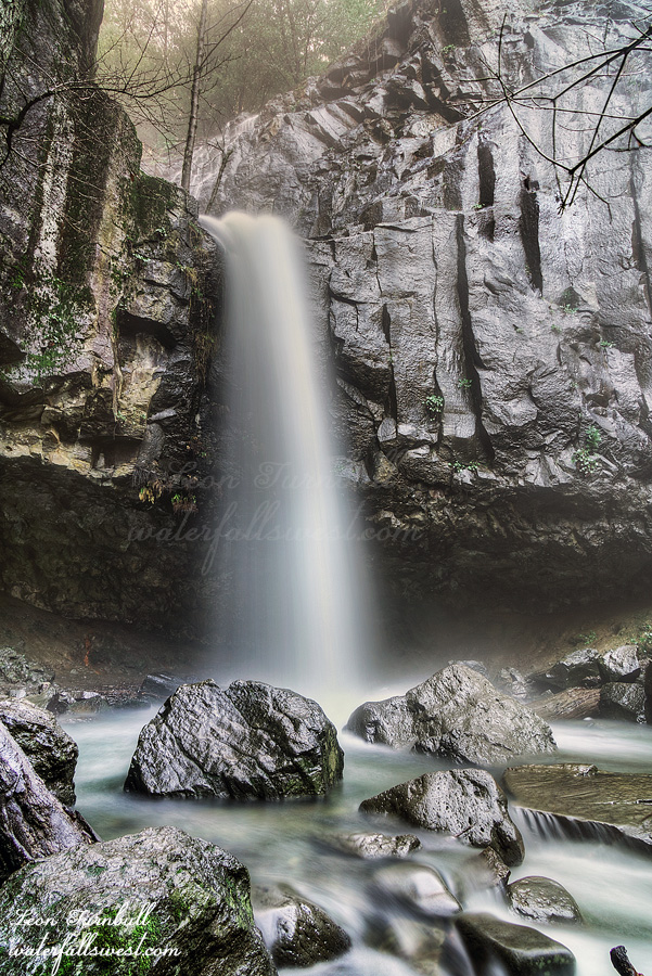
My primary goal for this trip was to get down to Jewel Falls. It is a four mile hike from the campsite and it gets early sun so this is why I had to hike in the dark. Much of the hike is on a road. I did not even realize that it was possible to drive your vehicle on this road. I saw a few cars parked along the road including one exactly at the trail where I had to go down to the falls. They were blocking the trail. What am I supposed to do about this? I had no choice but to walk through their camp. They heard me in their tent so I said “just passing through”. The guy rudely said “WHAT ARE YOU DOING?” I said, “going down to the waterfall”. On the way back they were up and the guy again was rude to me, saying “it’s not cool to walk through our camp, DUDE”. “Well DUDE, you are literally blocking the trail, what the H&*& am I supposed to do?”. I was really kinda ticked off with them, frankly. I tried to be nice and polite and received rudeness in return. If you are going block access to a hiking trail you need to expect someone is going to come through your campsite.
It did not help that my hike was an UTTER FAILURE and I was upset about that and feeling extremely disappointed. I know people have been down to Jewel Falls in the past but it was the distant past. Jewel Falls is LOST. The trail is now completely overgrown. Impassable. The brush was OVER MY HEAD. I tried going through it. I tried multiple routes to find a way through or around it. I tried my best. I could not do it. I retreated. At least there was no more poison oak.
On the way back I saw a guy parked along the road with his car hood up, looking into it. For the third time this trip I was nice again, asking if he needed help (though there was nothing really I could do to help him). He was polite though, at least, and said he was fine.
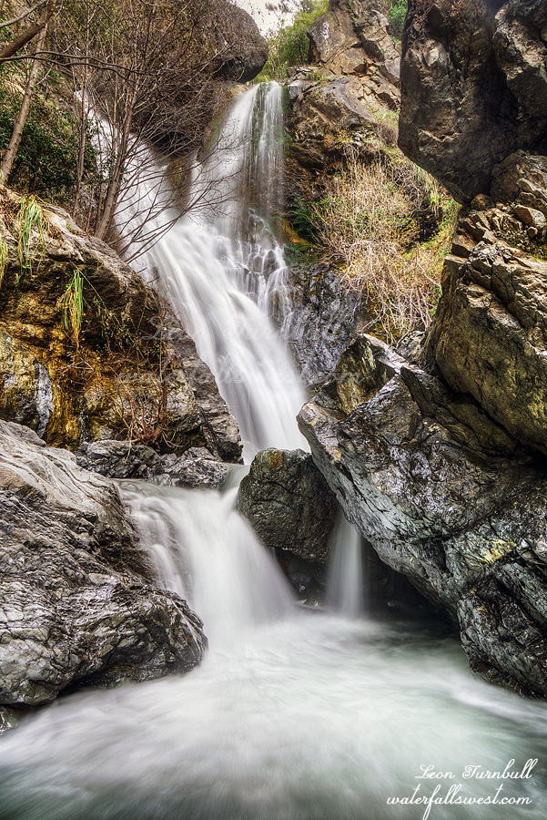
There were a lot of hikers on the way back down the Salmon Creek Falls trail. A lot of day hikers. Too many hikers. Some had dogs. Hopefully they escaped the ticks. One dog was barking at me, probably because the trail was narrow and he could not get by. The lady apologized but I told her I have a barking dog as well. Journey will bark her head off to protect her mama but if she is alone with me she will not bark at all. Funny girl. I decided to stop at Upper Salmon Creek Falls. It was about 11AM and still in shade. I was not planning to go down here again and I skipped it on the way up. However, since I failed at Jewel Falls I decided to go down to this waterfall. It was a small consolation. I did manage to get a different composition from the last time I was here so that is a plus. I got back to the car at about 1:30PM and made the long drive home. It was a rough two days in Ventana Wilderness.
Ventana Wilderness. I am a glutton for punishment. Why do I always return here? Brush as thick as thieves. Poison oak as abundant as bunnies in spring. Ticks as huge as dragon flies. It is not going to be pretty.
I left the house at 3:30AM. The fog is back. It is back with a vengeance. Visability was down to about 20 ft. I swear. This fog was thicker than we had it earlier this winter. At least from what I saw. I have not seen fog this thick since I was little. The fog going up the Rossland Trail hill in British Columbia where I lived was thicker than pea soup in winter. And my dad drove up it like gangbusters. Ha ha. Well I slowed down for this fog. And then it was gone. Just like that. And then it returned again further along. So this is how it is going to be, eh?
Highway 1 is open now. This cuts off about 30-40 minutes from my drive. I knew it was going to be a busy weekend there with the holiday and with it being the first weekend the road has been open in years. I was not wrong.
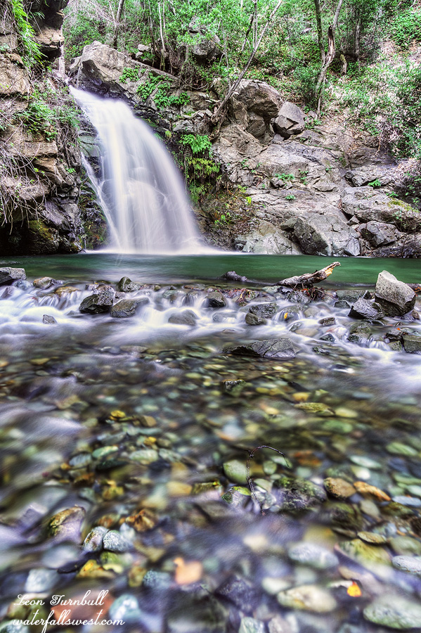
I arrived at the Salmon Creek Falls trailhead at about 8:30AM. There were already a lot of people here. I wanted to get a photo of the big waterfall from the bottom this time. I did not have a photo from there yet. I was able to get right up to it although it was not easy and involved a lot of creek crossing and boulder scrambling. There were tree branches obsuring the view but I expected that. So all was good.
I did make a huge mistake, however, and got into the poison oak. I was not paying attention. So before I even started my big hike I already had poison oak on me. I tried to wash it off but it did not help. I ended up getting a bad rash including some in my eye. Argh.
I had thought about bringing Journey on this hike but wisely decided not to. I was worried about the ticks. I have heard that the ticks are already horrendous this year and this is Ventana Wilderness. Tick Central. The worst place on Earth. The ticks are the size of dragon flies (almost). As it turned out there were not that many after all. I saw just one on the first day. The next day there were more, about ten, and one that got on me. Not really bad. I was expecting much worse. Even so, Journey probably would have gotten a few on her but that didn’t turn out to be the biggest problem. The hike was incredibly difficult, gaining 3000 ft. in elevation. I was dead tired by the end of the day. Journey has not done 3000 ft. before so I think she would have really struggled on the hike.
I arrived at Lion Den camp about 2PM. It did not occur to me until afterwards but it is not necessarily such a great idea to camp somewhere named “lion den”. This could get really bad. Why is it called this? There was one other guy already at the camp. For some reason he did not take the best spot. He left it for me. It was a fantastic spot up on a bluff with an ocean view. It may have been because he had a hammock but there was a spot on the bluff in which he could have set that up. I did not complain. I was treated to a very beautiful sunset. Apparently his water filter had broken and he was trying to boil water for drinking but not able to do so. I do not understand how you go backpacking and cannot boil water. Nonetheless, after I was finished using mine I let him borrow it so he could filter his water. I am such a nice guy! He was grateful but apparently not that grateful and I may have regretted being so nice. Stay tuned for the rest of the story …
The weather forecast for Bodega Bay this weekend was cloudy skies. This would be perfect for me to go see multiple waterfalls. It was going to be a great day. Of course the stupid forecaster was wrong again. It was a sunny day. At least I was able to see three waterfalls in good lighting conditions.
I was not planning to take Journey on this trip because it is a very long drive and she would not be able to go on all the hikes I had planned. Then it occurred to me I should invite my wife to come along. She is not able to go on any hikes right now but she loves the ocean and she would not mind waiting for Journey and myself to hike, and afterwards we could go to the beach and then have lunch in Bodega Bay. It was a good plan.
The main hike I wanted to do was 6 miles in Sonoma Coast State Park. There are two waterfalls here that I have not been to before. Journey and I set off down the trail leaving mom at the car to read her book. It was a very nice trail, a little muddy but not bad at all. It was a gorgeous morning.
We went to the upper falls first. Most people have no clue that an upper falls even exists. Thanks to my friend Mike for telling me about this one. The trail is difficult with a lot of fallen logs to negotiate but it is much better than I expected. Journey had no troubles with it. I think she had a lot of fun jumping over and crawling under all the logs. The last part is very steep and we had to take our photos on the side of a very steep hill. Journey had no place to sit down. I did not spend much time here though. I had to hurry and get to the other waterfall before the sun found it.
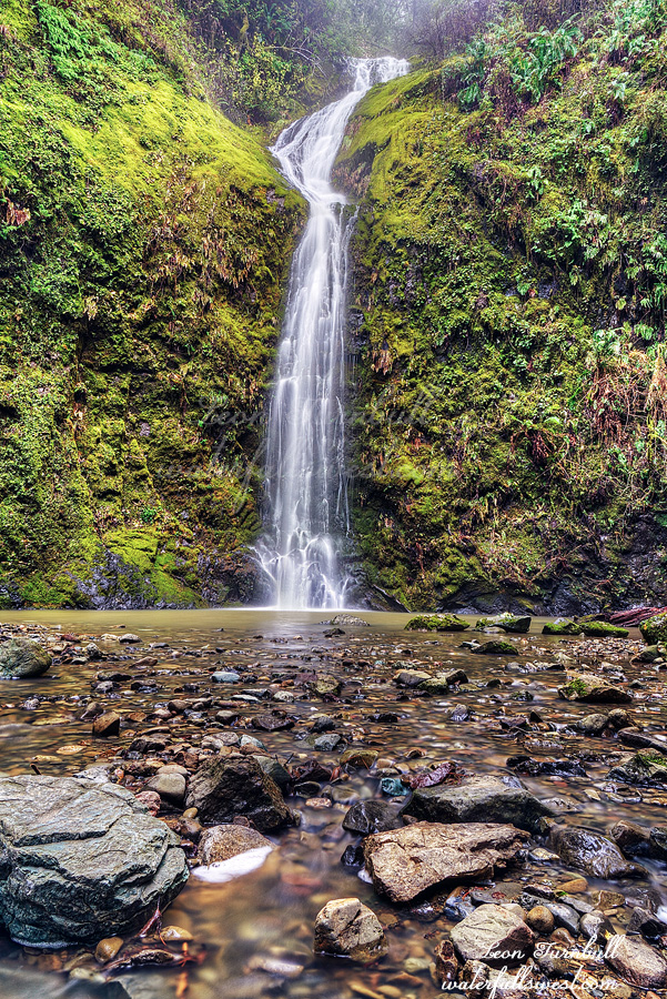
Willow Creek Falls is 76 ft. high. It is a real beauty hidden off the main path. It was flowing quite well after all the recent rains and we were the only ones here to enjoy it. Journey ate her snack while I took photos. Then we climbed back up the mountain to find mom waiting for us. Journey was so tired she did not even greet mom back at the car before flopping down on the seat (that is very strange because she loves her mom so much). However, she found a lot more energy to play fetch when we got to the beach in Bodega Bay. It was a wonderful day on the Sonoma Coast.
Our whole family was sick before we went to Canada. Tara and Jadon had the flu, Nekoda and I had colds. My wife claims our colds turned into bronchitis or RSV or something. I don’t know but I had a horrendous lingering cough. We were getting over it and not contagious anymore by the time we started the trip but we still had those horrible coughs.
My energy was non-existent as well. I did not do much hiking up in Canada as I had wanted to. I took Journey out on some easy hikes in the snow. She needs exercise every day. I did not do anything difficult. The only waterfall I went to was Marysville Falls which I go to every time I am up there. It is a very easy hike. We continued on down to the river which also is an easy hike but coming back up the hill was a monstrosity for me because of my lack of energy and sickness. It did me in for the rest of the day. Journey had no such troubles coming back up the hill. She was not sick, thankfully.
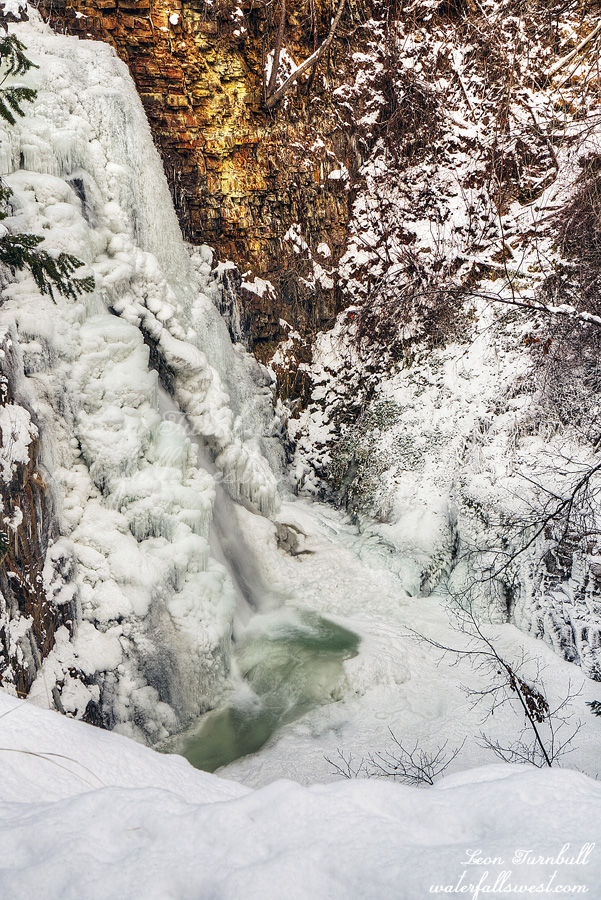
Marysville Falls was almost completely frozen. It is always interesting to see what it will be like in the winter. How frozen will you be this time, my dear Mary? I think they have had a fairly warm winter up there so far. Only in the week or so before we got there did it get cold and they got some snow. I guess it was enough to freeze over the waterfall. I was surprised. It was a nice easy hike to dear Marysville Falls.
After Christmas we drove to Canada to visit my family. It was somewhat sad for me because we would first be attending my mom’s memorial in Rossland. It was not a surprise that she passed but I do really miss her greatly. There were so many little things on the trip or places we went that made me think of her and miss her.
On the way we made a quick stop at Hedge Creek Falls. There has been a lot of rain in California this month but not much snow. As of Jan 1, the snow pack is in very bad shape: 45% of normal (north), 70% (central), 92% (south). Precipitation is well over 100% of normal throughout the state. However, we need the snow, not the rain. People will exclaim: global warming! If it is all due to global warming then explain why the snow pack was normal last year and the year before that. You can’t. Maybe it is just a bad year for snow in California. Hopefully we will get more snow in January, however. There was a lot of flooding because of the rain before Christmas. There was some legitimate bad flooding in southern California and some due to king tides in Marin county but others I don’t understand. Redding, for instance. They only got four inches of rain but had bad flooding. They were saying it was a 50 year storm. That is baloney. It was not a 50 year storm. 4 inches of rain is not that much. Plenty of times in recent years they had 4 inches of rain (and no flooding). I can tell you the dates if you want me to. On our own street there was a little flooding because leaves were blocking the drains and the city did not clear them out before the storm. They knew the storm was coming but they did not bother to clear the drains.
Hedge Creek Falls was roaring. There were cascades falling above the waterfall and down into the top of the falls. I think I have just seen that once before and I had the same issue then. How to photograph it? I could not figure it out. There is no decent angle to photograph the waterfall with the above cascades so I just photographed the main drop from the other side. It was wet and misty going behind the falls. Journey did not want to get wet! She went as far up on the inside of the cave as she could to avoid getting wet. She is so funny. It was a nice and quick stop at Hedge Creek Falls before we continued our journey to Canada.