July 6. This was to be my final backpacking trip for the summer. Just when (you might think) the snow is melting out and everyone else is finally getting out backpacking, I am quitting. Yeah, strange perhaps, but the bugs are also coming out to play now, and I hate hate hate the bugs, so I tend to not go out much in the summer. I actually went on one more backpacking trip this year (six) than I did last year. Considering that I also went to Scotland/Ireland for 10 days, I think that is pretty darn good! My trips this year tended to be shorter trips because I already took so many days off work for the overseas trip. I also had more failed backpacking trips this year (four) than last year. That is quite a lot and the reasons vary (ticks, snow, stream crossings, brush) but I usually made up for the failed trips with different ones.
I have heard a lot of people talking about this year and all the snow, afraid to go out in the snow and wondering where they can go backpacking with no snow. At the same time, I have heard other people going on crazy dangerous trips in the snow (with no problems – for them). I think it all depends on your comfort level and the more you go out and the more prepared you are, then the more you will be able to do. For example, one of my failed trips (last week) was going to be a big adventure into the Mokelumne Wilderness. Except that I came across one very dangerous snow field with a huge drop off into the abyss. One mistake and I would be dead. I chose to live and retreat. I am sure others could have traversed this snow field with no problem, but I only had micro spikes. With crampons and ice axe (and experience), I am sure I could have done it. Experience is a big thing. I read often about people dying because they do things beyond their capabilities and without proper preparedness. Also, it helps to be not afraid of heights. Yeah right.
This long-ish weekend (which was not a long weekend for myself), I returned to the Mokelumne Wilderness, to the same location. This would be a scaled down trip from what I had planned the week before (because I only had two days), and also I would be taking a different route (to bypass that dangerous snow field). The snow was still there. Lots of it. There was anywhere from 1 to 5 feet of snow. In some places, I just walked on the snow with my boots. In a few places, I needed to use the micro spikes but there was nothing dangerous on this route. It was just extremely tiring walking on the snow. On a trail that is mostly flat, it is not mostly flat when there is snow. You are constantly hiking up and down the snow mounds, which adds up to a lot of extra elevation, and let’s not mention the huge ankle breaking sun cups you are walking over. Without a GPS, following the trail is impossible, and I lost the trail a few times even with a GPS. All in all, it is just very tiring and very slow going.
You might think that since it was a long-ish weekend, I would see plenty of other backpackers/hikers. I saw zero people the entire weekend. I saw some horse tracks at the beginning but they were going off to another location. I saw one other set of recent tracks in the direction I was going. However, they stopped before the top of the pass. I guess the snow was too much for him/her. I was alone in the Mokelumne Wilderness.
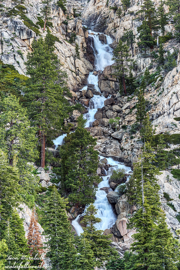
It was 2PM when I came to the junction for the first waterfall I wanted to see. I had hiked for 5.5 hours and only gone 8.5 miles. I determined that it would be at least two hours (likely more) until I reached my planned destination (the second waterfall), but I was already beat up, and the next day going back would be brutal, especially if I took the detour to this first waterfall as planned. I decided to skip the second waterfall and go down to camp at the first one. I was ok with doing this because I really want to come back to this area again anyway, when I have a lot more time.
It was only one mile, but it still took over an hour to get down to the creek. It is a 600 ft. descent, and there is no trail. The first part was really nice, with very wide open granite. It reminded me of the Desolation Wilderness. The last part was steep and brushy. It reminded me of my recent trip to West Cherry Creek in the Emigrant Wilderness. It took a while to get through the brush and down the granite cliffs, but I made it down to the creek and found a campsite.
I thought the mosquitoes would be bad on this trip. I was expecting the worst. However, there was only one single mosquito that I swatted in the evening (there were a few more in the morning – but hardly worth mentioning, and I did not even break out the repellent).
So … stupid mistake number one: I FORGOT MY DINNER! Actually, this was the only mistake on this trip, but how on earth does one go backpacking and forget their dinner! I had to eat my next day’s lunch for dinner. That meant I had no lunch for the next day, but thankfully, I was planning to be back at the car by noon and I had snacks, so I figured I should be ok. (and I was).
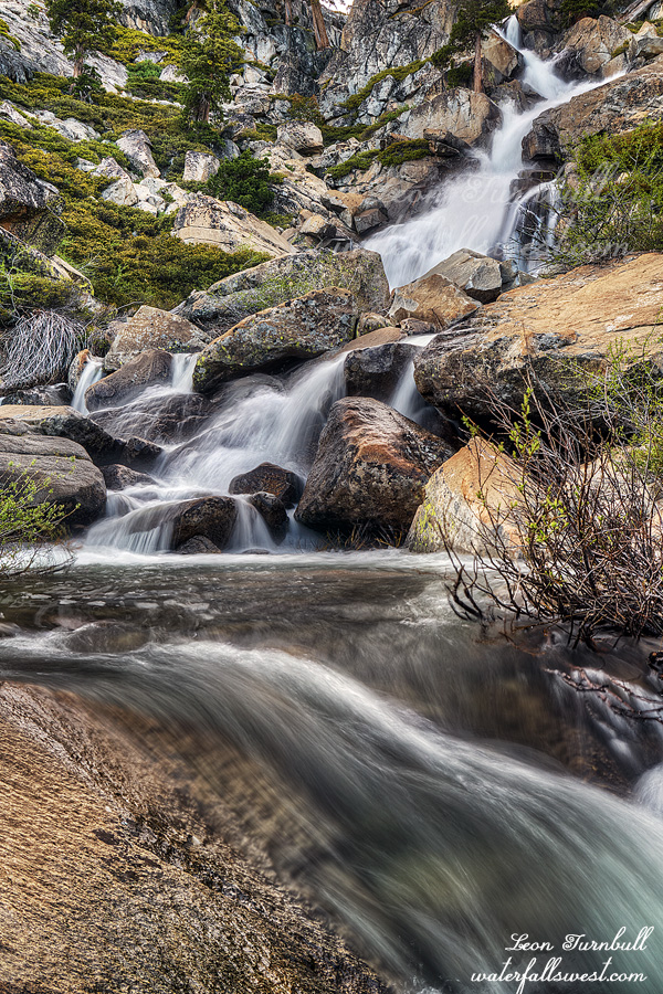
The next problem: how would I get up to the waterfall? My camping spot was beside the creek about a half mile below the falls. There was a huge mound of heavy brush between myself and the waterfall. After a bit of exploring, I realized there was absolutely no possible way to get through or around that brush. There was only one option: cross the creek and try on the other side. It looked pretty brushy on the other side as well, but maybe it would possible. It would really suck to come all the way down to this waterfall and not even be able to see it!
Could I even cross the creek? The creek was flowing quite swift (still) and deep, and in some places it was definitely not crossable. Nonetheless, I found one place near my campsite that looked “not too bad”, and so after my lunch/dinner, I made my way to this spot to attempt the crossing, needing to remember that in a couple hours (when I came back), the creek would be quite a bit higher than this. The crossing was up to my thighs, but really not a problem at all. I did not anticipate it would be much worse in a couple hours (and it wasn’t).
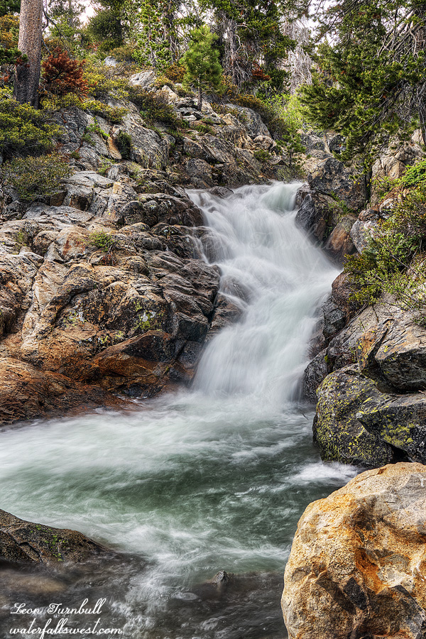
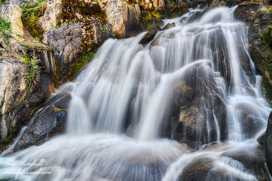
On the other side, I donned my hiking boots and made my way upstream. It was not so brushy on this side. There were a couple spots but really not too difficult, and I quickly made my way to the bottom of the waterfall. It was gorgeous! Now I had to wait an hour for the sun to go down before I could take photos. It was worth the wait. Cole Creek Falls is a beauty, and I suspect few people (if any) have ever seen it before.