As I drove up to Oroville (yet again), I debated to myself where I should hike. Should I go to Feather Falls (again)? Or should I go on a different hike to a new waterfall? I did want to go to Feather Falls. We had over 10 inches of rain in the past few days. Feather Falls would be a monster. I have seen it at full force before, but that was a long time ago, and also was before I had a good camera. I really wanted to go back there. However … I also wanted to do this other hike to find something new. It would be awesome as well for sure. I decided to go for the new waterfall. The decision was made. I continued on my journey to Oroville.
But alas, things do not always work out as planned, do they? When I got to the Feather Falls turnoff, I found snow on the road. This is very low elevation, and there is already snow here. For my planned hike, I would be at 1500 ft. higher than this. It was pretty clear to me that I would not be able to drive anywhere close to where I wanted to go, there would be way too much snow on the road, and it would be pointless to waste time trying to drive up there. I made the turnoff to Feather Falls.
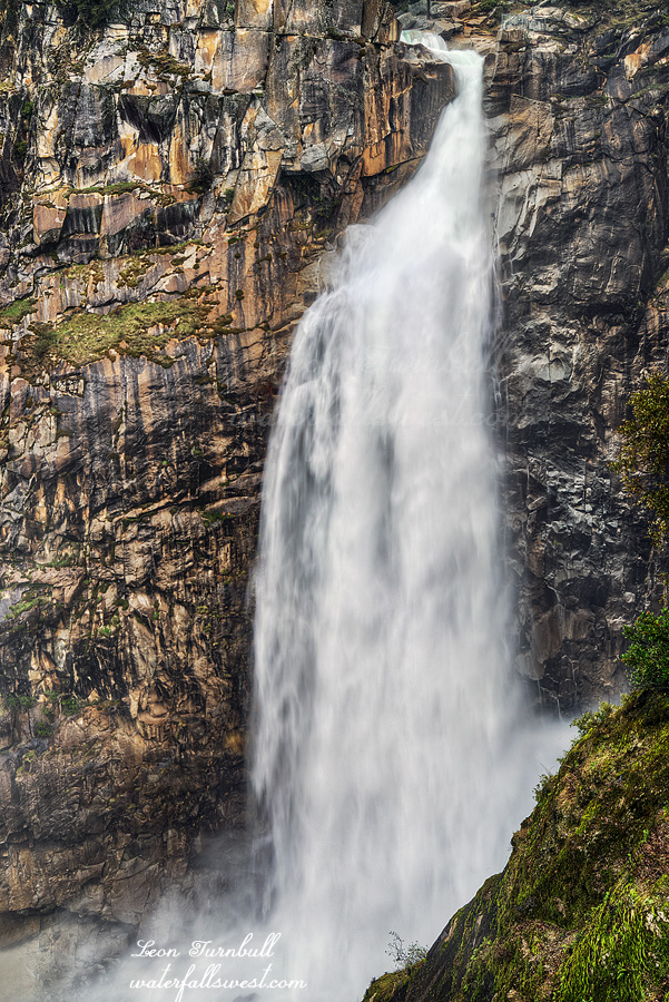
Feather Falls is certainly no small consolation prize.
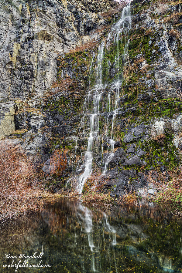
There were creeks flowing along the trail that are normally dry. Frey Creek was amazing. I’ve never seen so much water in that creek. I knew Feather Falls would be awesome. The anticipation was mounting but the hike seemed to take a lot longer than usual. I was not dawdling either. I began to wonder if Feather Falls would be just too much. There would be so much mist at the overlook, that I would not be able to take any photos at all. It was a pretty big concern, but it was unwarranted. There was no mistiness at the overlook, but there was a lot of mist on the waterfall. Feather Falls was a monster. A good monster. It was not what I would call “in flood”, though. The river had come down a lot in the last couple days. If I had been here two days earlier, the river would have had about twice the flow. Hard to believe but it would have been even more spectacular. Nonetheless, it was still incredible.
It really bugs me that there is always so much trash at Feather Falls. I just do not understand people. You want to come out in nature to see a beautiful waterfall, and then trash it? I picked up a lot that I saw along the trail, but there was just a ton of it thrown down in places that would be very dangerous or impossible to go pick up (particularly, at the overlook). Please people! If an empty can really is too heavy for you to carry back to your car, then at least leave it by the trail where someone else can pick it up for you. I do not want to take out your trash, and I should not have to take out your trash, but I will do it.
Anyhow, I spent about 1.5 hours at the falls, taking lots of photos and video, and enjoying the view. Then I headed back. I was surprised I did not see anyone else on the trail. I would think others would have the same idea as me, to see Feather Falls at monster flow. I almost made it all the way back to the trailhead, then I finally saw some other people just starting out their hike. There were just a couple cars in the parking lot. It was certainly a most special day at Feather Falls.
Posted in Northern CA, Waterfalls by leapin26: February 16, 2019
I did get the poison oak itch from my hike last weekend. Indeed, I got the oak in my eye. I could not see anything on Monday morning, and had to call in sick for work. This is the third time this has happened to me. Last time was about a year ago. Thankfully … I still had enough drugs leftover from the last time. My wife did not have to take me to the doctor again (which she was grateful for), and by Tuesday morning, I am all better. It would sure be nice if I could just buy these drugs without a prescription. It kinda sucks having to go pay the doctor $200 or so, in order to get a prescription for something I need, and then go pay $ to buy the drugs, so I can get rid of the poison oak in my eye. Also, it would be even better if I did not get oak in my eye in the first place! I have been very careful about avoiding oak, and honestly, I thought I was careful this time, and I did not think I would get any poison oak itch this time either. I don’t know what happened, but somehow I missed something in my cleaning up, or maybe I was just in too much of it. Anyhow …
After my hike to Wild Oat Falls, I got back to the car, very tired. It was raining. I really wanted to do a second hike (actually more than 2 hikes), but I was so tired from the first hike, very wet, and I did not want to go out in the rain any more. I had my lunch in the car, and checked my weather app, not expecting any let up in the rain for the afternoon. However, surprise, it said the rain was apparently going to stop in about 30 minutes or so, for a brief time. Well, I suppose I could do a second hike (an easy hike) after all.
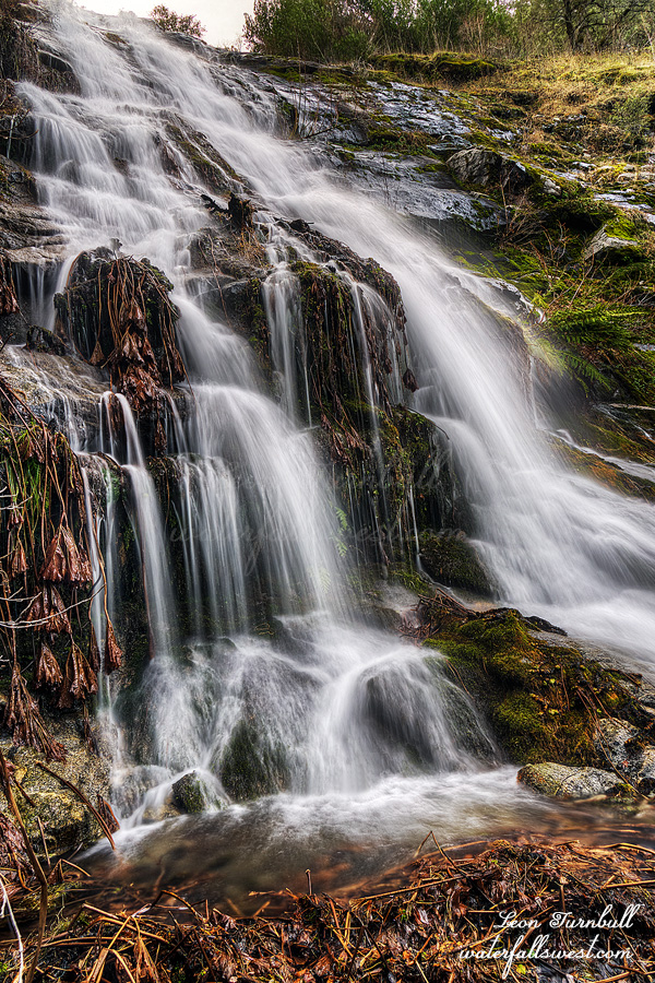
My friend Mike told me this was an EASY waterfall. With a capital E-A-S-Y. Umm, yeah, not exactly E-A-S-Y. It was not H-A-R-D. However, the hike did gain about 300 or 400 feet, and the last part involved whacking through some brush and poison oak to the edge of a very steep cliff, looking down on the waterfall. I would not call that easy, especially the part where I am treading on pins and needles at the edge of the cliff, trying to photograph the waterfall. Anyhow, I managed to do it, and got back to the car before the rain started up again. It is certainly a very pretty waterfall.
Posted in San Francisco Bay, Waterfalls by leapin26: February 12, 2019
I was back in the Bay Area for an exciting weekend adventure. This time, I was back to see the Devil. Mt. Diablo State Park, that is. It has been a while, a long while, since I was last here. I really wanted to try to get to Wild Oat Falls. Did I make it? Well, I think you know that already, but it was killer, very difficult, and poison oak infested. I almost blew it, though.
There was a big storm coming in, but it was supposed to be cloudy and showery all morning. It was not showery at all. It was also not cloudy. Well it was cloudy when I started the hike.
Whenever I am here, the trail to Donner Creek is especially muddy. Ridiculously muddy. But it was good to see the creek flowing well from all the rain. Praise God for the rain. We are now well over average for the year so far. The waterfalls should be fantastic.
Thanks to my friend Mike, I had a good route planned for Wild Oat Falls, and it was my full intention to follow this route. But alas, that did not happen. Enter poison oak. Well, you see, I thought it might be good to go to Donner Creek Falls first. It is on the way and would be a bit easier (I thought) to go to those waterfalls first, even though I’ve been to them before. I should not have done that. But anyway, I did. I spent a lot of time, far too much time, scrambling around those waterfalls, and tiring myself out. Now the sun was coming out. The clouds were all gone. It was supposed to be cloudy all morning! Nope. Not Cloudy. By the time I could get up to Wild Oat Falls, now, it would be in the sun, and that is the waterfall I really wanted to get to. I blew it! I should have gone up to Wild Oat first! I knew it, too. Ugh.
However … all was not lost. I saw a path heading up the canyon from the Donner Creek Falls. I was not planning to go this way. I knew there would be a lot of poison oak this way. Guess what? There was a lot of poison oak. However, it was much faster doing this now then going my original route. I could not avoid touching the oak. I gave up trying, and just trounced right through the stuff. Hoping beyond all hope, that I will avoid getting the itch this time. (actually … I have not gotten the poison oak itch in a long time – knock on wood). It was a tough route, climbing up the canyon this way. The waterfall was much further than I thought it was. This was NOT the right way to go to it! I continued climbing, and finally I could see the falls. It was still in shade. Could I make it in time? I still had a long way to go. Finally I reached the viewpoint. It was still in shade. I was ecstatic. Wild Oat Falls is a stunning 83 ft. high waterfall. Such magnificence! I took photos and enjoyed the view. I did not go back down via Donner Creek Falls, I went back the way I had initially intended to come to this one. It was much much easier. And no poison oak! (but it was too late about that, anyway). It was a long hike back down the mountain. By the time I got back to the car, the clouds were back. It was raining. Yeah!
Posted in San Francisco Bay, Waterfalls by leapin26: February 9, 2019
As of Feb. 1, here are your stats for the year thus far: Snow pack is 101% of average (northern CA), 103% (central Sierra),98% (southern Sierra). Rain is 96% of average (northern CA), 92% (central Sierra), 97% (southern Sierra). So as you can see, we are pretty darn average for the year so far. The good news is that February is starting out with a bang (the above stats do not include the storm that started on Feb. 1). I like being average. I have said it before. I wish we had average precipitation EVERY YEAR, instead of the huge ups and downs that we usually have in California. We will have to see how we end up at the end of this year with two more months to go in the winter. I am sure liking how February is starting off.
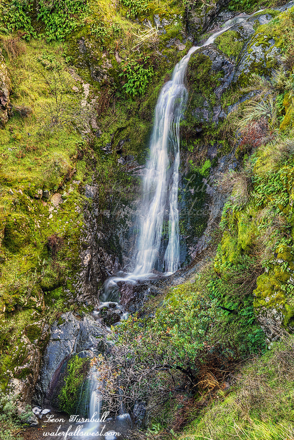
As for this photo, is it a pretty average photo of an average waterfall? This is Upper Merlin Falls, 53 ft. high. When I first went to Merlin Falls a couple years ago, I did not go to this upper Falls. Why not? It is not difficult! On that day, I totally wrenched my back on my first hike of the day. I could only BARELY hobble up to the lower falls (which is by the roadside). Going up to the upper falls was out of the question. Driving home that day was a nightmare. I am only now just getting back to this one. So many waterfalls to see, not enough time. Enjoy.
Posted in Northern CA, Waterfalls by leapin26: February 2, 2019
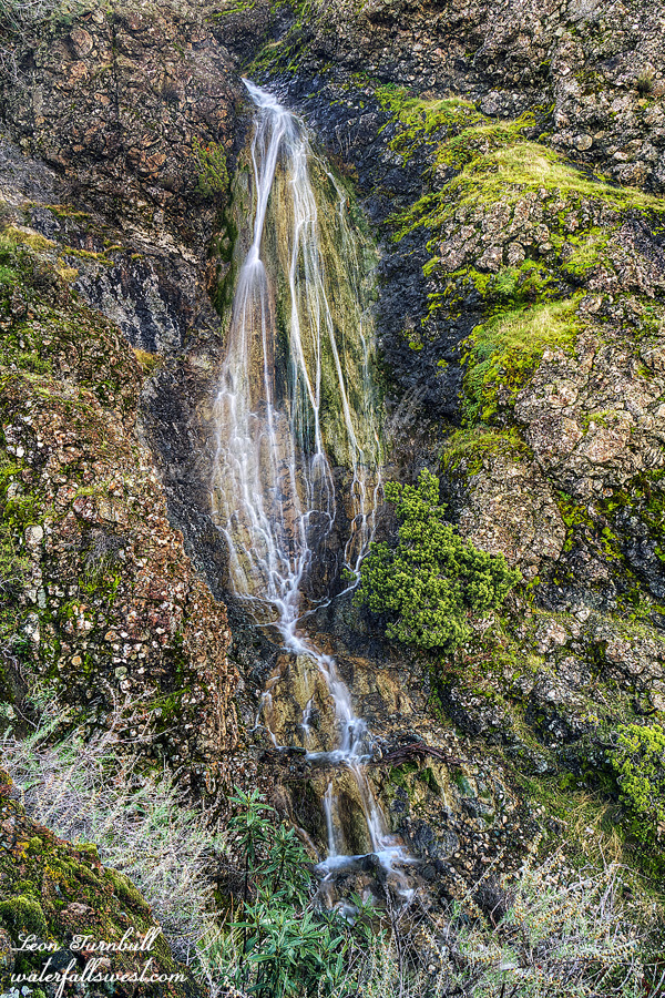
This is a new waterfall for me. Tobin Falls, 117 ft. high. It is a real beauty. At higher flows, it would be amazing. I found that the creeks on this side of the river were flowing quite a bit less than the other side, generally speaking. I think that is because there was no snow on the mountains on this side, and there was snow on the other side. Weird.
Anyway, to get to this one, you need to walk along the railroad tracks, which is always a bit unnerving, wherever you may be, but I saw no trains the entire morning. In the afternoon, I did see quite a few trains while I was hiking to Chambers Creek. Weird.
Posted in Northern CA, Waterfalls by leapin26: January 29, 2019
