|
|
Easy |

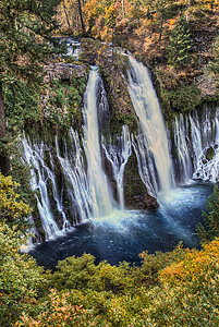
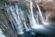
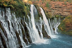
Image 1 of 6; Click arrow to scroll or click image to enlarge |
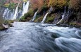
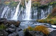
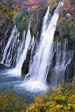
Location: Burney, McArthur Burney Falls Memorial State Park, Shasta County Stream: Burney Creek Alternate Names: Height: 129 ft. Access:     Distance: 1 mile (loop) or 2.4 miles (loop) Elevation: 2900 ft. (+/- 200 ft.) Season: year-round Form:  Lat/Long:41.01083, -121.65167 Directions:Along Hwy #89, at McArthur Burney Falls Memorial State Park, near Burney. From Hwy #299 junction 5 miles east of Burney, turn north on Hwy #89 and drive 5.9 miles to park entrance. There is a $8 parking fee. |


9 Miles N Burney CA (Elev. 3054 ft)
TodayRain and snow showers likely before noon, then rain showers. Some thunder is also possible. High near 43. West southwest wind 10 to 13 mph, with gusts as high as 30 mph. Chance of precipitation is 100%. Little or no snow accumulation expected.
Tonight
A chance of rain and snow showers before 11pm, then snow showers likely between 11pm and 2am, then rain and snow showers after 2am. Low around 31. South southwest wind 5 to 10 mph, with gusts as high as 29 mph. Chance of precipitation is 80%. New snow accumulation of less than a half inch possible.
Tuesday
Rain and snow showers, becoming all rain after 11am. High near 44. Southwest wind 5 to 7 mph. Chance of precipitation is 100%. New snow accumulation of less than a half inch possible.
Tuesday Night
A chance of rain showers, mixing with snow after 8pm, then gradually ending. Widespread frost after 11pm. Otherwise, partly cloudy, with a low around 25. West wind around 6 mph becoming calm in the evening. Chance of precipitation is 30%. Little or no snow accumulation expected.
Wednesday
Widespread frost, mainly before 10am. Otherwise, mostly sunny, with a high near 49. Calm wind.
Wednesday Night
Widespread frost, mainly after 11pm. Otherwise, partly cloudy, with a low around 25.
Thursday
Widespread frost, mainly before 10am. Otherwise, sunny, with a high near 53.
Thursday Night
Widespread frost, mainly after 1am. Otherwise, mostly clear, with a low around 27.
Friday
Widespread frost, mainly before 9am. Otherwise, sunny, with a high near 58.
Friday Night
Widespread frost, mainly after 2am. Otherwise, mostly clear, with a low around 29.
Saturday
Widespread frost. Otherwise, sunny, with a high near 64.
Saturday Night
Widespread frost. Otherwise, clear, with a low around 31.
Sunday
Widespread frost. Otherwise, sunny, with a high near 66.
| Clark Creek Falls | 2.16 miles | |
| Rock Creek Falls | 3.43 miles | |
| Pit River Falls | 9.68 miles |
| Shasta Cascade | Waterfalls Home Page |