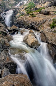
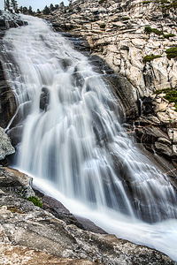
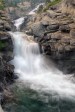
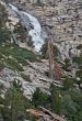
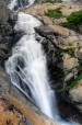
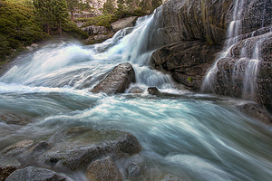
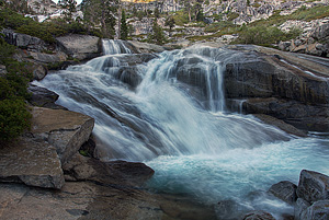
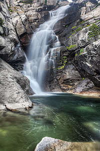
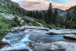
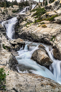
Best of the BestBest of the BestBest of the BestBest of the BestBest of the Best   Horsetail Falls Moderate


Image 1 of 10;
Click arrow to scroll or click image to enlarge
Lower tier of Horsetail Falls
Location: Strawberry, Desolation Wilderness, Eldorado National Forest, El Dorado County
Stream: Pyramid Creek
Alternate Names:

Height: 790 ft.
Access:   hike   dog  
Distance: 2.8 miles (RT)
Elevation: 6100 ft. (+700 ft.)
Season: Apr-Sep
Form:   horsetail
Lat/Long:38.83056, -120.12335
Directions:Along Hwy #50 at Twin Bridges, 2 miles east of Strawberry. Note there is now a $5 parking fee here.

You can see the impressive Horsetail Falls cascading down the mountain from busy Highway 50 on the way to South Lake Tahoe. But remember to keep your eyes on the road, or you will end up in the ditch. It is especially impressive in springtime during snow-melt. The first time we came was late in the year (August), and we thought the waterfall was great. We came back in the spring (June) and we were amazed. I had to up my ranking from 8 to 9. Wow! Park at the trailhead at Twin Bridges, with now a $5 parking fee. There are usually a lot of cars parked here on weekends, so there might quite a few people here; this is a very popular destination.

Follow the signs straight ahead to the wilderness boundary (not the Pyramid Creek loop trail). At the boundary, you will need to fill out a permit to continue up to the waterfall. The trail is unclear in places as you scramble up granite rocks to the waterfall. But just remember to keep the creek on your right and the waterfall ahead of you, and you will not get lost. It is only a 1.4 mile hike but it takes about 45 minutes to an hour. As you are hiking to the waterfall, look for two or three other tall unnamed cascades falling down the mountains to your right. These would be seasonal falls, only to be seen in the springtime. But quite interesting, nonetheless. When you reach Horsetail Falls, you will be treated to a spectacular display of water rushing down the mountainside.

If you are ambitious, you can continue scrambling up the mountain beside the creek to get to the top of the waterfall. This is quite strenuous. There is not much of a trail, you are essentially just scrambling up the mountain. Head slightly away from the creek as you go up (though, you will always have the waterfall in view). I do not recommend taking children to the top of Horsetail Falls. I found it a bit dangerous in places coming back down. Good hiking boots are a must! These granite rocks are quite smooth and slippery, even when dry. Many people have died here at this waterfall by losing their step on the slippery rocks, so please be careful.

You can take the Pyramid Creek loop trail on the way up or back to the falls (instead of going straight to the wilderness boundary, follow the signed trail towards the creek). If you do this, there is another really nice cascade right along the trail. I call this Lower Horsetail Falls. It is a really nice slide about 91 ft. high, and definitely worth seeing.

Because Horsetail Falls is so huge, it is practically impossible to measure its height with any degree of accuracy. A collaborated effort from myself and fellow waterfall guru Bryan Swan came up with a figure of 790 ft. This is no doubt not completely accurate, but it is within the ball park range, and does give you a relative idea of how immense this waterfall really is.

Get Google Maps directions to trailhead

Zoom out on map to see all nearby waterfalls:

Other waterfalls nearby:

Ropi Lake Falls 0.88 miles
Lower Horsetail Falls 1.19 miles
Upper Rocky Canyon Falls 1.26 miles
Pyramid Lake Falls 1.29 miles
Gefo Lake Falls 1.41 miles
Rocky Canyon Falls 1.52 miles
Pyramid Peak Falls 1.77 miles
East Waterfall Camp Falls 2.46 miles
Lost Lake Falls 2.89 miles
Waterfall Camp Falls 2.96 miles
Middle Waterfall Camp Falls 3.03 miles
Lower Waterfall Camp Falls 3.15 miles
West Waterfall Camp Falls 3.16 miles
Lyons Creek Falls 3.19 miles
Far Glen Alpine Falls 3.24 miles
Heather Lake Falls 3.25 miles
Susie Lake Falls 3.40 miles
Upper Glen Alpine Falls 3.68 miles
Gilmore Lake Falls 3.89 miles
Lower Glen Alpine Falls 4.25 miles
Twin Lakes Falls 4.50 miles
Half Moon Lake Falls 4.54 miles
Upper Crystal Basin Falls 4.96 miles
Umpa Lake Falls 5.10 miles
Crystal Basin Falls 5.53 miles
Hawley Grade Falls 5.66 miles
Gertrude Lake Falls 5.69 miles
Lower Upper Truckee River Falls 6.06 miles
Upper Upper Truckee River Falls 6.07 miles
Upper Truckee River Falls 6.13 miles
Lower Gertrude Lake Falls 6.14 miles
Azure Lake Falls 6.24 miles
Fontanillis Lake Falls 6.73 miles
Jones Fork Silver Creek Falls 6.80 miles
Upper Cascade Falls 6.91 miles
Cascade Falls 7.30 miles
Lower Lake Lois Falls 7.30 miles
Lower Velma Lake Falls 7.40 miles
Eagle Lake Falls 7.42 miles
Upper Eagle Falls 8.31 miles
Lower Eagle Falls 8.41 miles
Caples Creek Falls 8.54 miles
Girard Creek Falls 9.52 miles
North Fork Big Silver Creek Falls 9.74 miles
South Fork Silver Creek Falls 9.80 miles

High Sierra Waterfalls Home Page