|
|
Easy |

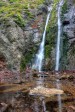
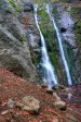
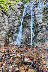
Image 1 of 3; Click arrow to scroll or click image to enlarge Lower tier of Pfeiffer Falls (46 ft) |
Location: Big Sur, Pfeiffer Big Sur State Park, Monterey County Stream: Pfeiffer Redwood Creek Alternate Names: Height: ~80 ft. Access:   Distance: 1 mile (RT) Elevation: 300 ft. (+300 ft.) Season: Dec-May Form:  Lat/Long:36.25694, -121.78056 Directions:Along Hwy #1 at Pfeiffer Big Sur State Park, 2 miles south of Big Sur (26 miles south of Carmel). Follow signs to Pfeiffer Falls trailhead in park. |


2 Miles ESE Big Sur CA (Elev. 2103 ft)
OvernightRain likely. Mostly cloudy, with a low around 47. South southwest wind around 8 mph. Chance of precipitation is 60%. New precipitation amounts of less than a tenth of an inch possible.
Monday
Rain likely, mainly before 11am. Mostly cloudy, with a high near 53. West southwest wind 7 to 10 mph. Chance of precipitation is 60%. New precipitation amounts between a tenth and quarter of an inch possible.
Monday Night
Rain likely, mainly before 11pm. Mostly cloudy, with a low around 41. West northwest wind 10 to 14 mph, with gusts as high as 20 mph. Chance of precipitation is 60%. New precipitation amounts between a tenth and quarter of an inch possible.
Tuesday
Rain. High near 50. West northwest wind around 14 mph, with gusts as high as 24 mph. Chance of precipitation is 90%. New precipitation amounts between a quarter and half of an inch possible.
Tuesday Night
A 50 percent chance of rain, mainly before 11pm. Mostly cloudy, with a low around 41. Breezy, with a northwest wind 17 to 22 mph, with gusts as high as 30 mph. New precipitation amounts of less than a tenth of an inch possible.
Wednesday
Mostly sunny, with a high near 53.
Wednesday Night
Partly cloudy, with a low around 41.
Thursday
Mostly sunny, with a high near 54.
Thursday Night
Mostly clear, with a low around 41.
Friday
Sunny, with a high near 60.
Friday Night
Mostly clear, with a low around 44.
Saturday
Sunny, with a high near 63.
Saturday Night
Mostly clear, with a low around 47.
| Andrew Molera Falls | 2.96 miles | |
| Mill Creek Preserve Falls | 7.65 miles | |
| Pine Falls | 7.86 miles | |
| Pick Creek Falls | 8.45 miles | |
| Upper McWay Falls | 8.88 miles | |
| McWay Falls | 8.98 miles | |
| Canyon Falls | 8.99 miles |
| Central Coast | Waterfalls Home Page |