We have a small storm coming into our area this weekend, but it is not supposed to give us very much precipitation. I am so anxious for winter to get started here, we need a lot more rain before the waterfalls get going. It was in the 80’s this past week, if you can believe it. It is November, right?
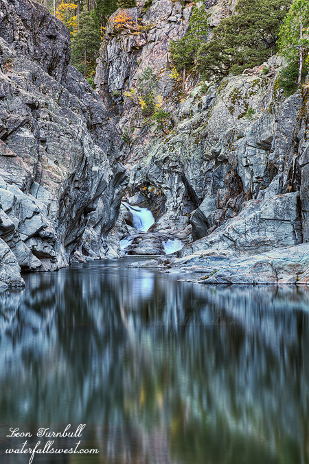
In the meantime, while we wait for the winter rain to get started, here is one more from Lundy Canyon. This is the very bottom of the monster 537 ft. high waterfall in Lundy Canyon. You can sort of see the upper section if you look closely. It is an incredibly neat spot. I love how this section drops through this very narrow slot at the bottom. I really want to come back here in the spring when the creek is rushing through here. However, it might be impossible to get to this spot because it requires crossing the creek, which is probably not going to be possible in the spring.
Posted in Eastern Sierra, Waterfalls by leapin26: November 8, 2012
When my friends come hiking with me, they know that they may not always get what is advertised. Plans can change on a dime. Strike outs happen. My friend Rob knows this, or at least I hope he does by now.
The plan was to hike down to Heath Falls from Soda Springs. It was going to be an epic hike. However, when we got to Soda Springs we found that the road was snowed in! We were forced to turn around or risk getting very stuck. This snow was from the big storm a couple weeks ago, and it was still not melted. I was shocked. I figured for sure the road would be clear by now. Not so, and I was quite disappointed. I think Rob was disappointed as well, especially since I made him get up at such an ungodly hour to go on this hike with me in the dark.
Plan B was suggested by Rob, to go on a different hike at Blue Canyon (which I had been on before, but Rob had not). It was a very good idea, however, I did not have my maps with me for this hike, and I could not remember exactly how to get to the trailhead. There was a very tricky turnoff, and I did not know where it was, and I could not find it in the dark. Strike two.
Plan C was to go back to the South Yuba River, and down to the Emerald Pools waterfalls. I knew I could get to these waterfalls again. Secretly though, I was not sure I could find them without my maps. I had only been down this route once before, and I had some doubts as we hiked along, though I did not share those doubts with Rob because I did not want to have a complete strike out this morning. In the end, I found the spot, thankfully. The river was flowing at about 80 cfs, which is quite low compared to when I was here before. Even yesterday (after the rain this week), it was flowing at about 150 cfs, and it dropped by about half in just one day. But at least it was flowing, and at least we had something to photograph. No strikeout.
Posted in Northern Sierra, Waterfalls by leapin26: November 3, 2012

Why does the Devil always get nice places named after him anyway? Hmmm? Devils Falls? Devils Peak? Devils Punchbowl? Devils Canyon? That should not be allowed, I think.
Here is the standard view of Devil’s Falls, or the one that I like to shoot the most anyway. It involves crossing the creek, which is always tricky because the rocks are always wet and slick. You really gotta be careful doing this. I was, and there were no unfortunate mishaps. We have a little bit more rain coming tonight, but I don’t think it will be too much. It is still early in the season. I must keep telling myself this. 😉
Posted in Sacramento, Waterfalls by leapin26: October 31, 2012

I said I was not going to share my photo of Shirttail Creek Falls. I lied. Here it is. It is not a great shot of this waterfall by any means, but it turned out ok. There is a huge dropoff here into the creek, and a narrow, wet, slippery ledge, with no handholds, that you can walk out on to get a view of the falls. I was not feeling too daring so I did not go out very far this time. Next time … next time I think I will try to get to the bottom of the falls. Not sure how, but perhaps if I approach it from downstream, I will be able to get down to creek level. Maybe.
So does everyone know how Shirttail Creek got its name? It is a pretty interesting story. Back in the year 1849, two miners were prospecting in the area and happened to come across another miner panning for gold. He was wearing absolutely nothing in the way of clothing except for a shirt, not overly lengthy. Embarrased, the newcomers asked the other miner what the name of the place was. After glancing down at his outfit, he answered, “do not know any name for it yet, but we might as well call it shirt-tail, as anything else”. Thus, the creek was named.
Posted in Sacramento, Waterfalls by leapin26: October 28, 2012

In my strange mind waterfall season begins after the first storm of the winter. That storm happened this week, mid October. The mountains in the Tahoe area received anywhere from 2 to 3 feet of snow from this storm, not a bad start to the year as this is much earlier than usual for our first storm. So all this means that waterfall season has begun! To celebrate, I headed over to Devils Falls after work on Wednesday. I was anticipating the area would have had much more rain than they actually received on Wednesday so I’m not really sure what effect the rain had in the creek’s flow, but it was pretty low. I tried for a different view of the falls from the left side this time. After shooting this waterfall I went down to Shirttail Falls but it was almost dark when I got down there and I was not happy with my photo so I’m not sure if I’ll share it. That creek had low flow as well. I was also freaked about that ledge and I did not venture as far out on it as I have done in the past. There is nothing to hold onto and the ground was wet and potentially slippery (with a huge dropoff). I think I’m also getting more wimpy in my old age. Haha.
The other main reason for going to Devils Falls was to check out the effects of the forest fire that happened here in the summer. It began very near Devils Falls, however I had heard that the lovely greenery around Devils Falls was not touched by the fire at all. Well it is true that the falls did not seem to get burned but everything around it on all sides sure did. Indeed it is very strange that Devils Falls itself was untouched. The scourge from the fire can be seen from Yankee Jim bridge all the way down the North Fork on the east side of the river as far as I could see. Indian Creek Falls was very likely burned. Shirttail Creek Falls was definitely burned and even the south side of Shirttail Creek was burned. I did not venture up to Mexican Gulch Falls as it was dark (but now that I’m thinking about it, I realize I should have). It was definitely very interesting to see the area and the fire’s effects. It also seemed that the road down to the falls is getting worse, which may or may not have anything to do with the fire. It seems narrower and more eroded than ever before. It is probably just my imagination.
Posted in Sacramento, Waterfalls by leapin26: October 25, 2012